
Fichier:Last Island Map4.JPG

Taille de cet aperçu : 705 × 600 pixels. Autres résolutions : 282 × 240 pixels | 564 × 480 pixels | 1 000 × 851 pixels.
Fichier d’origine (1 000 × 851 pixels, taille du fichier : 132 kio, type MIME : image/jpeg)
Ce fichier et sa description proviennent de Wikimedia Commons.
Description
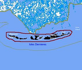
| Description | Map of remaining portions of Last Island, Louisiana |
| Date | |
| Source | Map drawn by en:User:sf46 based on information gathered from U.S. Federal Government website: census.gov |
| Auteur | en:User:sf46 |
| Autorisation (Réutilisation de ce fichier) |
Released to public domain |
Conditions d’utilisation
Ce média est dans le domaine public des États-Unis d’Amérique car son auteur est l’administration américaine comme précisé dans le code fédéral au Titre 17, Chapitre 1, Section 105. Pour en savoir plus : droit d’auteur.
Attention : Ceci ne concerne que le travail du Gouvernement Fédéral et pas celui des États, ou d’une autre subdivision géographique ou politique du pays.
|
 | |
| Ce fichier a été identifié comme étant exempt de restrictions connues liées au droit d’auteur, y compris tous les droits connexes et voisins. | ||
Historique du fichier
Cliquer sur une date et heure pour voir le fichier tel qu'il était à ce moment-là.
| Date et heure | Vignette | Dimensions | Utilisateur | Commentaire | |
|---|---|---|---|---|---|
| actuel | 27 août 2010 à 03:52 | | 1 000 × 851 (132 kio) | Lynntoniolondon | {{Information |Description=Map of remaining portions of Last Island, Louisiana |Source=Map drawn by User:sf46 based on information gathered from U.S. Federal Government website: [http://www.census.gov census.gov] |Date=6/26/2009 |Author=[[User:sf4 |
Utilisation du fichier
La page suivante utilise ce fichier :
Usage global du fichier
Les autres wikis suivants utilisent ce fichier :
- Utilisation sur en.wikipedia.org
- Utilisation sur ja.wikipedia.org
- Utilisation sur www.wikidata.org