
Fichier:Lage des Landkreises Hof in Deutschland.PNG
Pas de plus haute résolution disponible.
Lage_des_Landkreises_Hof_in_Deutschland.PNG (176 × 234 pixels, taille du fichier : 5 kio, type MIME : image/png)
Ce fichier et sa description proviennent de Wikimedia Commons.
Description
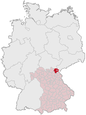
Karte erstellt auf der Grundlage der opengeodb.de-Umrisse.
Moved from de.wikipedia.org, first uploaded by de:Benutzer:Geograv.
Conditions d’utilisation
This image was generated with OpenGeoDB. The information there is placed in the public domain, images generated from OpenGeoDB are derivative works without passing the threshold of creativity, they are therefore also public domain.
| Ce document n'est pas soumis au droit d'auteur et est donc dans le domaine public, car il est composé exclusivement d'informations qui sont dans le domaine public et ne contient aucune modification qui en ferait une œuvre originale. |
Historique du fichier
Cliquer sur une date et heure pour voir le fichier tel qu'il était à ce moment-là.
| Date et heure | Vignette | Dimensions | Utilisateur | Commentaire | |
|---|---|---|---|---|---|
| actuel | 1 mars 2006 à 14:35 | | 176 × 234 (5 kio) | Tsca.bot | Karte erstellt auf der Grundlage der opengeodb.de-Umrisse - GNU-FDL Moved from http://de.wikipedia.org {{GFDL}} Category:Maps of Germany |
Utilisation du fichier
La page suivante utilise ce fichier :
Usage global du fichier
Les autres wikis suivants utilisent ce fichier :
- Utilisation sur cs.wikipedia.org
- Utilisation sur da.wikipedia.org
- Utilisation sur de.wikipedia.org
- Utilisation sur eo.wikipedia.org
- Utilisation sur hy.wikipedia.org
- Utilisation sur id.wikipedia.org
- Utilisation sur ja.wikipedia.org
- ホーフ郡
- ベルク (オーバーフランケン)
- デーラウ
- ファイリッチュ
- ガッテンドルフ (オーバーフランケン)
- ゲロルツグリュン
- ツェル・イム・フィヒテルゲビルゲ
- シュタムバッハ (オーバーフランケン)
- イシガウ
- ケディッツ
- シュパルネック
- ヘルムブレヒツ
- リヒテンベルク (オーバーフランケン)
- ナイラ (オーバーフランケン)
- ミュンヒベルク
- シャウエンシュタイン
- レーアウ
- オーバーコッツァウ
- バート・シュテーベン
- ヴァイスドルフ
- トローゲン (オーバーフランケン)
- コンラーツロイト
- シュヴァルツェンバッハ・アム・ヴァルト
- テーペン
- レグニッツローザウ
- シュヴァルツェンバッハ・アン・デア・ザーレ
- ゼルビッツ
- ロイポルツグリュン
- Utilisation sur ka.wikipedia.org
- Utilisation sur kk.wikipedia.org
- Utilisation sur lmo.wikipedia.org
- Utilisation sur pl.wikipedia.org
- Utilisation sur pt.wikipedia.org