
Fichier:Kenya corona county map 26032020.png

Taille de cet aperçu : 800 × 587 pixels. Autres résolutions : 320 × 235 pixels | 640 × 469 pixels | 979 × 718 pixels.
Fichier d’origine (979 × 718 pixels, taille du fichier : 71 kio, type MIME : image/png)
Ce fichier et sa description proviennent de Wikimedia Commons.
Description
| Description |
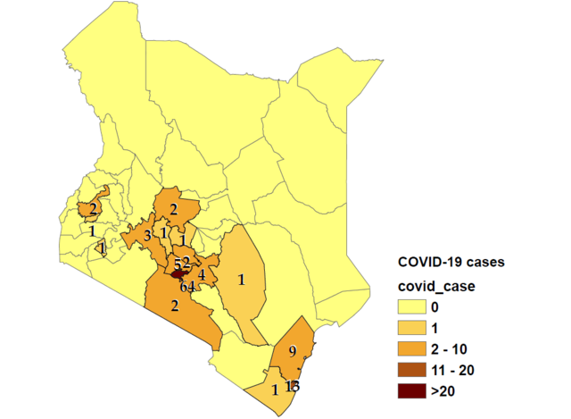
English: Map of counties with confirmed COVID-19 cases in Kenya as of 26 March 2020. |
| Date | |
| Source | Travail personnel |
| Auteur | Gozar |
Conditions d’utilisation
Moi, en tant que détenteur des droits d’auteur sur cette œuvre, je la publie sous la licence suivante :
Ce fichier est sous la licence Creative Commons Attribution – Partage dans les Mêmes Conditions 4.0 International.
- Vous êtes libre :
- de partager – de copier, distribuer et transmettre cette œuvre
- d’adapter – de modifier cette œuvre
- Sous les conditions suivantes :
- paternité – Vous devez donner les informations appropriées concernant l'auteur, fournir un lien vers la licence et indiquer si des modifications ont été faites. Vous pouvez faire cela par tout moyen raisonnable, mais en aucune façon suggérant que l’auteur vous soutient ou approuve l’utilisation que vous en faites.
- partage à l’identique – Si vous modifiez, transformez, ou vous basez sur cette œuvre, vous devez distribuer votre contribution sous la même licence ou une licence compatible avec celle de l’original.
Historique du fichier
Cliquer sur une date et heure pour voir le fichier tel qu'il était à ce moment-là.
| Date et heure | Vignette | Dimensions | Utilisateur | Commentaire | |
|---|---|---|---|---|---|
| actuel | 3 avril 2020 à 17:54 | | 979 × 718 (71 kio) | Gozar | made wider for visibility again |
| 3 avril 2020 à 17:52 |  | 854 × 719 (70 kio) | Gozar | widened image to increase visibility | |
| 3 avril 2020 à 17:42 |  | 523 × 702 (57 kio) | Gozar | added number labels for counties to map | |
| 3 avril 2020 à 17:26 |  | 496 × 671 (23 kio) | Gozar | updated to reflect distribution by county as of 3 April, 2020 | |
| 2 avril 2020 à 16:56 |  | 499 × 665 (22 kio) | Gozar | increased font size of legend to improve visibility | |
| 2 avril 2020 à 16:52 |  | 495 × 631 (21 kio) | Gozar | updated to have shaded map with number of cases per county with legend as of March 30 | |
| 1 avril 2020 à 23:37 |  | 527 × 663 (20 kio) | Gozar | updated to April 1 | |
| 26 mars 2020 à 17:02 |  | 439 × 574 (36 kio) | Gozar | Uploaded own work with UploadWizard |
Utilisation du fichier
Les 2 pages suivantes utilisent ce fichier :
Usage global du fichier
Les autres wikis suivants utilisent ce fichier :
- Utilisation sur ar.wikipedia.org
- Utilisation sur ca.wikipedia.org
- Utilisation sur it.wikipedia.org
- Utilisation sur pl.wikipedia.org
- Utilisation sur tr.wikipedia.org
- Utilisation sur uz.wikipedia.org