
Fichier:Helsinki tram map.png

Taille de cet aperçu : 600 × 600 pixels. Autres résolutions : 240 × 240 pixels | 480 × 480 pixels | 768 × 768 pixels | 1 200 × 1 200 pixels.
Fichier d’origine (1 200 × 1 200 pixels, taille du fichier : 98 kio, type MIME : image/png)
Ce fichier et sa description proviennent de Wikimedia Commons.
Description
| Description |
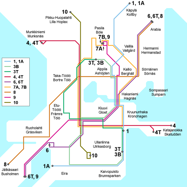
English: Map of the Helsinki tram network, current as of 30 March 2009. Place names in Finnish and Swedish. This file is being kept up to date (or at least attempted to) by Kjet.
Suomi: Kartta Helsingin raitiotieverkosta 30. maaliskuuta 2009 tilanteen mukaan. Paikannimet suomeksi ja ruotsiksi. Kjet pitää (tai ainakin yrittää pitää) tämän tiedoston ajantasalla.
Svenska: Kartan över Helsingfors spårvägslinjer, aktuell av 30 mars 2009. Namn på finska och svenska. Denna filet är uppdaterad av Kjet. |
| Date | |
| Source | Travail personnel |
| Auteur | Kjet |

|
Cette image (de type transport map) devrait être recréée dans un format vectoriel, en tant que fichier SVG. Cela offrirait plusieurs avantages : voir Commons:Media for cleanup pour plus d'informations. Si une version SVG de cette image est déjà disponible, merci de bien vouloir l'envoyer. Après cela, remplacez ce modèle par {{vector version available|nouveau nom d'image.svg}}.
|
Conditions d’utilisation
Moi, en tant que détenteur des droits d’auteur sur cette œuvre, je la publie sous la licence suivante :
Ce fichier est disponible selon les termes de la licence Creative Commons Attribution 3.0 Non transposée.
- Vous êtes libre :
- de partager – de copier, distribuer et transmettre cette œuvre
- d’adapter – de modifier cette œuvre
- Sous les conditions suivantes :
- paternité – Vous devez donner les informations appropriées concernant l'auteur, fournir un lien vers la licence et indiquer si des modifications ont été faites. Vous pouvez faire cela par tout moyen raisonnable, mais en aucune façon suggérant que l’auteur vous soutient ou approuve l’utilisation que vous en faites.
Historique du fichier
Cliquer sur une date et heure pour voir le fichier tel qu'il était à ce moment-là.
| Date et heure | Vignette | Dimensions | Utilisateur | Commentaire | |
|---|---|---|---|---|---|
| actuel | 3 février 2013 à 16:40 | | 1 200 × 1 200 (98 kio) | Kjet | Updated with the autumn 2012 extension of line 9 and the new line 6T opened in January 2013. |
| 11 juillet 2012 à 23:00 |  | 1 200 × 1 200 (96 kio) | Kjet | Updated with the changed route of line 8 from 2012-01-01. Apologies for the delay. | |
| 13 janvier 2010 à 11:22 |  | 1 200 × 1 200 (96 kio) | Kjet | Corrected the accidentally reversed directions for lines 7A and 7B. | |
| 29 mars 2009 à 21:51 |  | 1 200 × 1 200 (96 kio) | Kjet | {{Information |Description={{en|1=Map of the Helsinki tram network, current as of 30 March 2009. Place names in Finnish and Swedish. This file is being kept up to date (or at least attempted to) by Kjet.}} {{fi|1=Kartta Helsingin raitiotieve |
Utilisation du fichier
Aucune page n’utilise ce fichier.
Usage global du fichier
Les autres wikis suivants utilisent ce fichier :
- Utilisation sur en.wikipedia.org
- Utilisation sur es.wikivoyage.org
- Utilisation sur he.wikivoyage.org
- Utilisation sur it.wikipedia.org
- Utilisation sur ja.wikipedia.org
- Utilisation sur tr.wikipedia.org