
Fichier:Global microplastic abundance at the ocean surface (ArcGIS).jpg

Taille de cet aperçu : 597 × 600 pixels. Autres résolutions : 239 × 240 pixels | 478 × 480 pixels | 765 × 768 pixels | 1 019 × 1 024 pixels | 2 039 × 2 048 pixels | 3 386 × 3 401 pixels.
Fichier d’origine (3 386 × 3 401 pixels, taille du fichier : 1,13 Mio, type MIME : image/jpeg)
Ce fichier et sa description proviennent de Wikimedia Commons.
.jpg?uselang=fr)
Description
| Description |
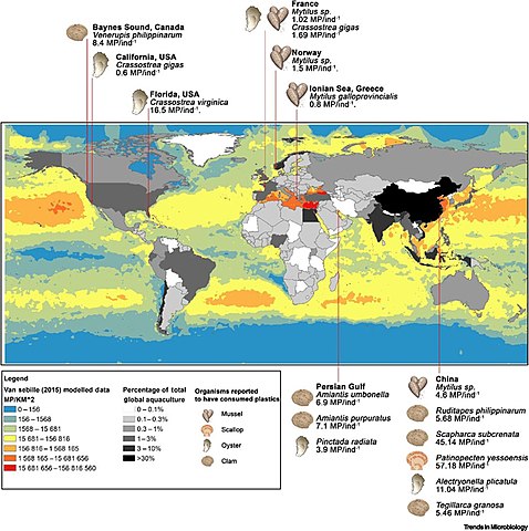
English: Global microplastic abundance at the ocean surface (ArcGIS) Modelled Sea-surface Microplastic Abundances (Particles km-2) Using Data from the Van Sebille Model (2015) with the Abundances Plotted on a Log Scale (Blue = Low, Red = High). |
| Date | |
| Source | [1] doi:10.1016/j.tim.2020.06.011 |
| Auteur |
Jake Bowley, Craig Baker-Austin, Adam Porter, Rachel Hartnell and Ceri Lewis |
Conditions d’utilisation
Ce fichier est sous la licence Creative Commons Attribution – Partage dans les Mêmes Conditions 4.0 International.
- Vous êtes libre :
- de partager – de copier, distribuer et transmettre cette œuvre
- d’adapter – de modifier cette œuvre
- Sous les conditions suivantes :
- paternité – Vous devez donner les informations appropriées concernant l'auteur, fournir un lien vers la licence et indiquer si des modifications ont été faites. Vous pouvez faire cela par tout moyen raisonnable, mais en aucune façon suggérant que l’auteur vous soutient ou approuve l’utilisation que vous en faites.
- partage à l’identique – Si vous modifiez, transformez, ou vous basez sur cette œuvre, vous devez distribuer votre contribution sous la même licence ou une licence compatible avec celle de l’original.
Historique du fichier
Cliquer sur une date et heure pour voir le fichier tel qu'il était à ce moment-là.
| Date et heure | Vignette | Dimensions | Utilisateur | Commentaire | |
|---|---|---|---|---|---|
| actuel | 14 septembre 2021 à 23:39 | | 3 386 × 3 401 (1,13 Mio) | Epipelagic | Uploaded a work by Jake Bowley, Craig Baker-Austin, Adam Porter, Rachel Hartnell and Ceri Lewis<br /> ArcGIS version 10.6.1 from [https://www.cell.com/trends/microbiology/fulltext/S0966-842X(20)30190-6] {{doi|10.1016/j.tim.2020.06.011}} with UploadWizard |
Utilisation du fichier
La page suivante utilise ce fichier :
Usage global du fichier
Les autres wikis suivants utilisent ce fichier :
- Utilisation sur af.wikipedia.org
- Utilisation sur en.wikipedia.org
.jpg)