
Fichier:Fisherman Island National Wildlife Refuge, Chesapeake Bay Bridge-Tunnel, Eastern Shore, Virginia (14423298724).jpg
Fichier d’origine (4 000 × 3 000 pixels, taille du fichier : 3,55 Mio, type MIME : image/jpeg)
Ce fichier et sa description proviennent de Wikimedia Commons.
.jpg?uselang=fr)
Description
| Description |
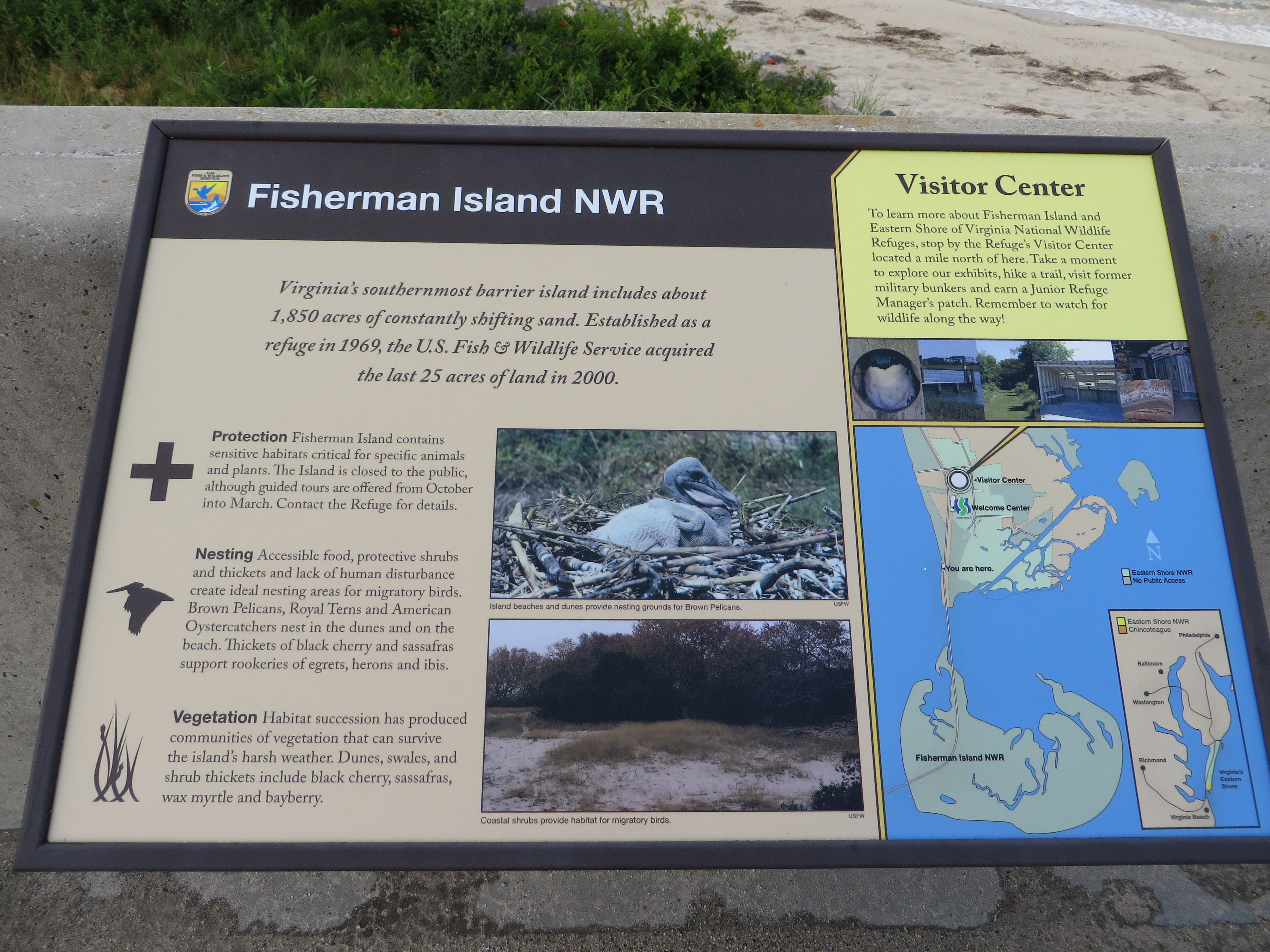
The Chesapeake Bay Bridge–Tunnel (CBBT) is a 23-mile-long (37 km) fixed link crossing the mouth of the United States Chesapeake Bay and connecting the Delmarva Peninsula's Eastern Shore of the state of Virginia with Virginia Beach and the metropolitan area of Hampton Roads, Virginia. The bridge–tunnel originally combined 12 miles (19 km) of trestle, two 1-mile-long (1.6 km) tunnels, four artificial islands, four high-level bridges, approximately 2 miles (3.2 km) of causeway, and 5.5 miles (8.9 km) of approach roads—crossing the Chesapeake Bay and preserving traffic on the Thimble Shoals and Chesapeake shipping channels. It replaced vehicle ferry services which operated from South Hampton Roads and from the Virginia Peninsula from the 1930s until completion of the bridge–tunnel in 1964. The system remains one of only ten bridge–tunnel systems in the world, three of which are located in Hampton Roads, Virginia. The CBBT complex carries U.S. Route 13, the main north–south highway on Virginia's Eastern Shore, and, as part of the East Coast's longstanding Ocean Highway, provides the only direct link between the Eastern Shore and South Hampton Roads regions, as well as an alternate route to link the Northeast and points in between with Norfolk and the Carolinas. The bridge–tunnel saves motorists 95 miles (153 km) and 1½ hours on a trip between Virginia Beach/Norfolk and points north and east of the Delaware Valley without going through the traffic congestion in the Baltimore–Washington Metropolitan Area. Initially, high-level bridges were contemplated to cross over the two main shipping channels on the selected route, Thimble Shoals Channel, which leads to Hampton Roads, and the Chesapeake Channel, which leads to points north in the Bay, notably the Port of Baltimore. However, the U.S. Navy objected, due to concerns that collapse of high level bridge(s) (due to either accidental or deliberate action) could cause a large portion of the Atlantic fleet based at the Norfolk Navy Base at Sewell's Point and other craft within the Hampton Roads harbor area to be blocked from access to the Atlantic Ocean. To address these concerns, the engineers recommended a series of bridges and tunnels known as a bridge–tunnel, similar in design to the Hampton Roads Bridge–Tunnel, which had been completed in 1957, but a considerably longer and larger facility. The tunnel portions, anchored by four man-made islands of approximately 5 acres (2.0 ha) each, would be extended under the two main shipping channels. en.wikipedia.org/wiki/Chesapeake_Bay_Bridge%E2%80%93Tunnel en.wikipedia.org/wiki/Wikipedia:Text_of_Creative_Commons_... |
| Date | |
| Source | Fisherman Island National Wildlife Refuge, Chesapeake Bay Bridge-Tunnel, Eastern Shore, Virginia |
| Auteur | Ken Lund from Reno, Nevada, USA |
| Lieu de la prise de vue | | Voir cet endroit et d’autres images sur : OpenStreetMap |
|---|
.jpg¶ms=037.120869_N_-075.969400_E_globe:Earth_type:camera_source:Flickr_&language=fr)
Conditions d’utilisation
- Vous êtes libre :
- de partager – de copier, distribuer et transmettre cette œuvre
- d’adapter – de modifier cette œuvre
- Sous les conditions suivantes :
- paternité – Vous devez donner les informations appropriées concernant l'auteur, fournir un lien vers la licence et indiquer si des modifications ont été faites. Vous pouvez faire cela par tout moyen raisonnable, mais en aucune façon suggérant que l’auteur vous soutient ou approuve l’utilisation que vous en faites.
- partage à l’identique – Si vous modifiez, transformez, ou vous basez sur cette œuvre, vous devez distribuer votre contribution sous la même licence ou une licence compatible avec celle de l’original.
| Cette image a été originellement postée sur Flickr par Ken Lund à l'adresse https://flickr.com/photos/75683070@N00/14423298724. Elle a été passée en revue le 3 novembre 2016 par le robot FlickreviewR, qui a confirmé qu'elle se trouvait sous licence cc-by-sa-2.0. |
Historique du fichier
Cliquer sur une date et heure pour voir le fichier tel qu'il était à ce moment-là.
| Date et heure | Vignette | Dimensions | Utilisateur | Commentaire | |
|---|---|---|---|---|---|
| actuel | 3 novembre 2016 à 18:47 | | 4 000 × 3 000 (3,55 Mio) | Ser Amantio di Nicolao | Transferred from Flickr via Flickr2Commons |
Utilisation du fichier
La page suivante utilise ce fichier :
.jpg)