
Fichier:European political map.jpg
Pas de plus haute résolution disponible.
European_political_map.jpg (616 × 600 pixels, taille du fichier : 306 kio, type MIME : image/jpeg)
Ce fichier et sa description proviennent de Wikimedia Commons.
Description
| Description |
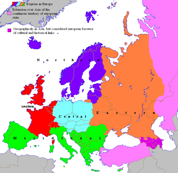
English: Rectified geopolitical areas of Europe since 2007
Français : Zones géopolitiques de l'Europe depuis 2007 |
| Date | |
| Source | Spiridon Manoliu's maps |
| Auteur | Spiridon Manoliu |
Conditions d’utilisation
| Moi, propriétaire des droits d’auteur sur cette œuvre, la place dans le domaine public. Ceci s'applique dans le monde entier. Dans certains pays, ceci peut ne pas être possible ; dans ce cas : J’accorde à toute personne le droit d’utiliser cette œuvre dans n’importe quel but, sans aucune condition, sauf celles requises par la loi. |
Historique du fichier
Cliquer sur une date et heure pour voir le fichier tel qu'il était à ce moment-là.
| Date et heure | Vignette | Dimensions | Utilisateur | Commentaire | |
|---|---|---|---|---|---|
| actuel | 10 septembre 2022 à 19:19 | | 616 × 600 (306 kio) | Рагин1987 | Small correction |
| 1 novembre 2014 à 20:52 |  | 616 × 600 (181 kio) | Spiridon Ion Cepleanu | Orthography & colours | |
| 30 mars 2009 à 15:12 |  | 616 × 600 (183 kio) | Spiridon Ion Cepleanu | {{Information |Description={{en|1=Rectified geopolitical areas of Europe since 2007}} {{fr|1=Zones géopolitiques de l'Europe depuis 2007}} |Source=Spiridon Manoliu's maps |Author=Spiridon Manoliu |Date=March 30, 2009 |Permission= |other_versions= }} <!- |
Utilisation du fichier
Aucune page n’utilise ce fichier.