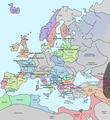
Fichier:Europe in 1345.png

Le contenu de la page n’est pas pris en charge dans d’autres langues.
Une page de Wikipédia, l'encyclopédie libre.

Fichier d’origine(1 075 × 1 168 pixels, taille du fichier : 114 kio, type MIME : image/png)

Ce fichier et sa description proviennent de Wikimedia Commons.

Description

Description A map of Europe in 1345, showing the location of events that took place in that year. The Black Plague's exact location in unknown, and the shaded area to the right represents rough scholarly estimates. It hit the Crimea in the following year.
Date
Source self-made from Image:Europein1328.png with GIMP
Auteur Teaandcrumpets
Cette image (de type historical map) devrait être recréée dans un format vectoriel, en tant que fichier SVG. Cela offrirait plusieurs avantages : voir Commons:Media for cleanup pour plus d'informations. Si une version SVG de cette image est déjà disponible, merci de bien vouloir l'envoyer. Après cela, remplacez ce modèle par {{vector version available|nouveau nom d'image.svg}}.
Cartes de l'histoire de l'Europe
BCE
aC

Weichselian ice age (c. 113,000–9700) · Neolithic expansion (c. 7000–4500) · Middle Neolithic (c. 4500–4000) · Late Neolithic (c. 4000–3000) · Copper Age – Corded Ware culture (c. 2900–2350) · Copper Age – Bellbeaker culture (c. 2800–1800) · Early Bronze Age – Unetice culture (c. 2300–1600) · Late Bronze Age – Urnfield culture (c. 1300—750) · Migrations (c. 1000–100) · Hallstatt & La Tène cultures (c. 800–100) · Roman Republic (510–40) · 220 · 218 · 200 · 201–100 · 58 · 49 · 39 · 30 BCE–6 CE


CE
dC

14 · 14–37 · 60 · 60 · 69 · 80 · Migrations 100–500 · 117 · 117 · 125 · Migrations 150–774 · Economy 180 · 271 · 293–305 · 337 · 395 · c. 395 · 400 · 400 · 450 · 457–61 · 476 · 480 · Franks 481–814 · Early Slavs 500–700 · 500 · 526 · 526–600 · Christianisation to 600 · c. 550 · 650 · Pontic Steppe 650 · 665 · 800 · Vikings 800–1050 · 814 · 843–70 · 850 · 900 · 912 · 998 · 1000 · 1000 · 1054 · 1092 · First Crusade 1095–99 · 1097 · 1135 · 1142 · 1147–49 · 1190 · 1190 · 1250 · c. 1250 · 1301-1400 · 1301-1400 · 1328 · 1345 · Black Plague 1347–51 · 1360 · 1400 · Trade routes c. 1400 · 1430 · 1470 · 1490 · 1492 · 1500 · 1519 · 1550 · 1560 · Religion 1560 · Religion 1600 · Religion 1618 · 1618–48 · 1648 · 1683 · 1700 · 1701 · 1708 · 1714 · 1721 · 1725–30 · 1739–1740 · 1740 · 1748–66 · 1783–1792 · 1787 · 1787 · 1789 · 1799 · 1812 · 1812 · 1812 · 1812 · 1813 · 1815 · 1815 · 1815 · 1818 · Ottoman Empire 1830–1923 · 1848–49 · 1861 · 1867 · 1871 · 1878 · 1890 · 1905 · 1911 · 1914 · 1914 · 1919 · 1919–29 · 1923 · 1929 · 1930 · 1940 · 1941–42 · 1942–45 · Cold War 1947–91 · 1950 · 1993–2006 · 2006 to date

(this template: · view · discuss )

Conditions d’utilisation

Public domain Moi, propriétaire des droits d’auteur sur cette œuvre, la place dans le domaine public. Ceci s'applique dans le monde entier.
Dans certains pays, ceci peut ne pas être possible ; dans ce cas :
J’accorde à toute personne le droit d’utiliser cette œuvre dans n’importe quel but, sans aucune condition, sauf celles requises par la loi.

Légendes

Ajoutez en une ligne la description de ce que représente ce fichier

Éléments décrits dans ce fichier

dépeint

Historique du fichier

Cliquer sur une date et heure pour voir le fichier tel qu'il était à ce moment-là.

Date et heureVignetteDimensionsUtilisateurCommentaire
actuel10 mai 2020 à 21:31Vignette pour la version du 10 mai 2020 à 21:311 075 × 1 168 (114 kio)Santasa99Corrections per Euroatlas - Historical Maps, http://www.euratlas.net/history/europe/1300/index.html Euratlas Periodis Web - Map of Europe in Year 1300
24 décembre 2017 à 14:58Vignette pour la version du 24 décembre 2017 à 14:581 075 × 1 168 (289 kio)Trey KincaidChanged Sicily who had his own kingdom
1 juillet 2012 à 21:30Vignette pour la version du 1 juillet 2012 à 21:301 075 × 1 168 (282 kio)Ludde23Changed Estonia from the red color of Sweden to the yellow color of Denmark, since Estonia was not Swedish at this time, but belonged to Denmark until 1346.
24 avril 2009 à 23:34Vignette pour la version du 24 avril 2009 à 23:341 075 × 1 168 (112 kio)Alex:DBorders corrected
15 novembre 2007 à 20:02Vignette pour la version du 15 novembre 2007 à 20:021 075 × 1 168 (110 kio)Teaandcrumpets(changed notre dame marker)
14 novembre 2007 à 01:03Vignette pour la version du 14 novembre 2007 à 01:031 075 × 1 168 (113 kio)Teaandcrumpets{{Information |Description= A map of Europe in 1345, showing the location of events that took place in that year. |Source=self-made from Image:Europein1328.png with GIMP |Date= 13 Nov 2007 |Author= Teaandcrumpets |Permission=

La page suivante utilise ce fichier :

Usage global du fichier

Les autres wikis suivants utilisent ce fichier :

Métadonnées