
Fichier:Egg Island, Bahamas ESA391953.jpg

Fichier d’origine (8 816 × 7 000 pixels, taille du fichier : 4,35 Mio, type MIME : image/jpeg)
Ce fichier et sa description proviennent de Wikimedia Commons.
Description
| Description |
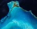
English: When it comes to eggs, most of us are probably thinking of the chocolate variety that we hope will pass our way this weekend, but they’re difficult to spot from space. Instead, we can offer you this gorgeous Copernicus Sentinel-2B picture of Egg Island in the Bahamas.
Covering just 800 sq m, Egg Island is officially an islet. This tiny uninhabited patch is at the northwest end of the long thin chain of islands that form the Eleuthera archipelago, about 70 km from Nassau. Its name perhaps originates from the seabird eggs collected here. The image, which Sentinel-2B captured on 2 February 2018, shows the sharp contrast between the beautiful shallow turquoise waters to the southwest and the deeper darker Atlantic waters to the northeast. Ripples of sand waves created by currents stand out in the shallow waters. These shallow waters are a natural nursery for sea turtles and other sea life. Any disturbance to this delicate ecosystem could spell disaster for wildlife. In fact, Egg Island was recently at risk of being developed as a cruise ship port, which would have meant dredging the seabed and destroying coral reefs. Fortunately, this plan didn't take hold because of the damage it would cause to the environment. This image is also featured on theEarth from Space video programme. |
| Date | |
| Source | http://www.esa.int/spaceinimages/Images/2018/03/Egg_Island_Bahamas |
| Auteur | European Space Agency |
| Autorisation (Réutilisation de ce fichier) |
contains modified Copernicus Sentinel data (2018), processed by ESA,CC BY-SA 3.0 IGO |
| Autres versions |
|
| Title | Egg Island, Bahamas |
| Set | Earth observation image of the week |
| System | Copernicus |
| Mission | Sentinel-2 |
| Location | Bahamas |
| Activity | Observing the Earth |
| Keywords | Islands |
Conditions d’utilisation
- Vous êtes libre :
- de partager – de copier, distribuer et transmettre cette œuvre
- d’adapter – de modifier cette œuvre
- Sous les conditions suivantes :
- paternité – Vous devez donner les informations appropriées concernant l'auteur, fournir un lien vers la licence et indiquer si des modifications ont été faites. Vous pouvez faire cela par tout moyen raisonnable, mais en aucune façon suggérant que l’auteur vous soutient ou approuve l’utilisation que vous en faites.
- partage à l’identique – Si vous modifiez, transformez, ou vous basez sur cette œuvre, vous devez distribuer votre contribution sous la même licence ou une licence compatible avec celle de l’original.

|
This image contains data from a satellite in the Copernicus Programme, such as Sentinel-1, Sentinel-2 or Sentinel-3. Attribution is required when using this image.
Attribution: Contains modified Copernicus Sentinel data {{{year}}}
The use of Copernicus Sentinel Data is regulated under EU law (Commission Delegated Regulation (EU) No 1159/2013 and Regulation (EU) No 377/2014). Relevant excerpts:
Free access shall be given to GMES dedicated data [...] made available through GMES dissemination platforms [...].
Access to GMES dedicated data [...] shall be given for the purpose of the following use in so far as it is lawful:
GMES dedicated data [...] may be used worldwide without limitations in time.
GMES dedicated data and GMES service information are provided to users without any express or implied warranty, including as regards quality and suitability for any purpose. |
Historique du fichier
Cliquer sur une date et heure pour voir le fichier tel qu'il était à ce moment-là.
| Date et heure | Vignette | Dimensions | Utilisateur | Commentaire | |
|---|---|---|---|---|---|
| actuel | 30 mars 2018 à 17:56 | | 8 816 × 7 000 (4,35 Mio) | Fæ | European Space Agency, Id 391953, http://www.esa.int/spaceinimages/Images/2018/03/Egg_Island_Bahamas, User:Fæ/Project_list/ESA |
Utilisation du fichier
Les 2 pages suivantes utilisent ce fichier :
Usage global du fichier
Les autres wikis suivants utilisent ce fichier :
- Utilisation sur az.wikipedia.org
- Utilisation sur ceb.wikipedia.org
- Utilisation sur es.wikipedia.org
- Utilisation sur www.wikidata.org