
Fichier:Earth Impact Database world map.svg

Taille de cet aperçu PNG pour ce fichier SVG : 512 × 256 pixels. Autres résolutions : 320 × 160 pixels | 640 × 320 pixels | 1 024 × 512 pixels | 1 280 × 640 pixels | 2 560 × 1 280 pixels.
Fichier d’origine (Fichier SVG, nominalement de 512 × 256 pixels, taille : 351 kio)
Ce fichier et sa description proviennent de Wikimedia Commons.
Description
| Description |
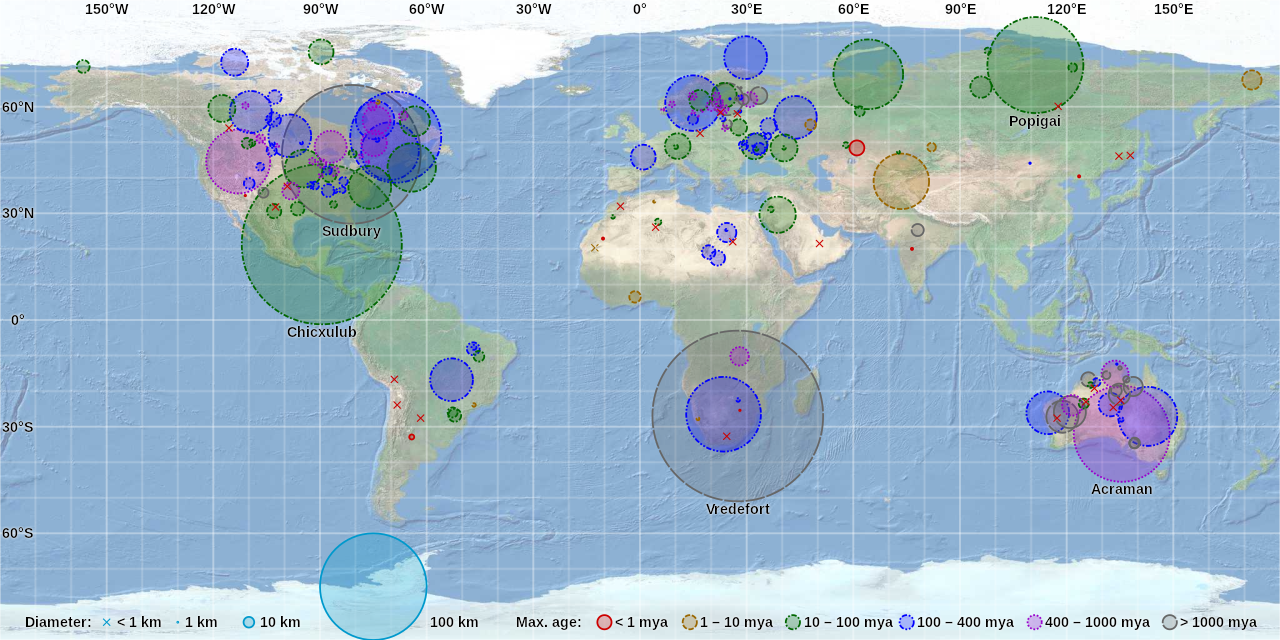
English: World map of craters on the Earth Impact Database by CMG Lee. Hover over or tap a circle or cross to highlight it and show its details. Background map is from https://earthquake.usgs.gov/learn/topics/plate_tectonics/majplatecolor.pdf and crater data is from http://passc.net/EarthImpactDatabase/. |
|
| Date | ||
| Source |
|
|
| Auteur | Cmglee, United States Geological Survey, Earth Impact Database |

Conditions d’utilisation
Ce fichier est sous la licence Creative Commons Attribution – Partage dans les Mêmes Conditions 4.0 International.
- Vous êtes libre :
- de partager – de copier, distribuer et transmettre cette œuvre
- d’adapter – de modifier cette œuvre
- Sous les conditions suivantes :
- paternité – Vous devez donner les informations appropriées concernant l'auteur, fournir un lien vers la licence et indiquer si des modifications ont été faites. Vous pouvez faire cela par tout moyen raisonnable, mais en aucune façon suggérant que l’auteur vous soutient ou approuve l’utilisation que vous en faites.
- partage à l’identique – Si vous modifiez, transformez, ou vous basez sur cette œuvre, vous devez distribuer votre contribution sous la même licence ou une licence compatible avec celle de l’original.
Historique du fichier
Cliquer sur une date et heure pour voir le fichier tel qu'il était à ce moment-là.
| Date et heure | Vignette | Dimensions | Utilisateur | Commentaire | |
|---|---|---|---|---|---|
| actuel | 16 juillet 2018 à 00:07 | | 512 × 256 (351 kio) | Cmglee | Support Safari on mobile iOS as per en:user_talk:Vincent_Mia_Edie_Verheyen#Email_questions. |
| 1 décembre 2017 à 08:36 |  | 512 × 256 (359 kio) | Cmglee | Label more notable craters and right-align field labels. | |
| 13 novembre 2017 à 22:53 |  | 512 × 256 (345 kio) | Cmglee | Use text overlay instead of tooltips. | |
| 11 novembre 2017 à 10:00 |  | 512 × 256 (297 kio) | Cmglee | User created page with UploadWizard |
Utilisation du fichier
Les 2 pages suivantes utilisent ce fichier :
Usage global du fichier
Les autres wikis suivants utilisent ce fichier :
- Utilisation sur ca.wikipedia.org
- Utilisation sur de.wikipedia.org
- Utilisation sur en.wikipedia.org
- Impact crater
- Impact event
- List of impact structures on Earth
- Earth Impact Database
- User:Cmglee
- List of impact structures in Africa
- List of impact structures in Asia and Russia
- List of impact structures in Australia
- List of impact structures in Europe
- List of impact structures in North America
- List of impact structures in South America
- User:Kazkaskazkasako/Books/Physical sciences
- User:Cmglee/svg
- Template:Earth Impact Database world map.svg
- Utilisation sur fa.wikipedia.org
- Utilisation sur pt.wikipedia.org
- Utilisation sur tr.wikipedia.org
- Utilisation sur zh.wikipedia.org