
Fichier:Early map of Lac Ouinipigon -- or Lake Winnipeg.jpg

Fichier d’origine (5 704 × 2 677 pixels, taille du fichier : 5,31 Mio, type MIME : image/jpeg)
Ce fichier et sa description proviennent de Wikimedia Commons.
| Description |
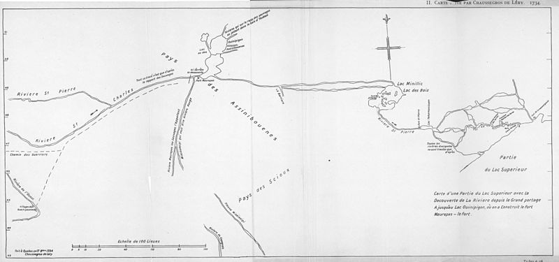
The following is the author's description of the photograph quoted directly from the photograph's Flickr page. "La Vérendrye Expedition. Carte d'une Partie du Lac Superieur avec la Découvert de La Riviere depuis le Grand Portage A jusqu'au Lac Ouinipigon, ou on a construit le fort Maurepas-le fort 1734 [facsimile]. [1:1,267,200]. In: Publications of the Champlain Society, 16. Journals and letters of La Vérendrye and his sons with Correspondence between the Governors of Canada and the French Court Touching the Search for the Western Sea. Toronto: The Map Specialty Co., 1927. As reproduced by: Toronto: The Champlain Society, 1927. This map has a very simple format. It indicates an east west alignment of the hydrographical features as in the Auchagach map, but on this occasion Lac Ouinipigon or des Assinibouenes (Lake Winnipeg), trends correctly north and south, and the River of the West has been eliminated. There are several rivers flowing from the northern end of Lake Winnipeg which the natives stated, pass into Hudson Bay. Moreover, there is a small lake with a short outlet river draining out into Lake Winnipeg on its northwestern side, which could possibly be a representation of Cedar Lake and the Lower Saskatchewan river. La Verendrye has indicated a main river, St. Charles, entering the southwest corner of the large lake. This river has two tributaries, a northern, St. Pierre, and a southern, Maurepas, Miscouesipe or Rouge. This is of course the Red-Assiniboine system, but there have been several mistakes made. St. Charles river is compounded of the actual Souris tributary as its upper trunk, with the main west-east flowing portion of the Assiniboine river as its central section, and the Red river as its downstream portion. St. Pierre river is the upper Assiniboine. The extent of knowledge of the French is shown by a line drawn across the river close to its mouth, which is stated to be where discovery ends. Also, from Indian report[s], is the Riviere de l%u2019Ouest (Missouri) with Ouachipouenne villages (Mandan) on its banks. villages (Mandan) on its banks. (Warkentin and Ruggles. Historical Atlas of Manitoba. map 27, p. 76) " |
|||||
| Date | 1734, published in 1927 | |||||
| Source |
originally posted to Flickr as Carte d'une Partie du Lac Superieur avec la Découvert de La Riviere depuis le Grand Portage A jusqu'au Lac Ouinipigon, ou on a construit le fort Maurepas-le fort 1734 (1927)
|
|||||
| Auteur | [1] | |||||
| Autorisation (Réutilisation de ce fichier) |
|

Historique du fichier
Cliquer sur une date et heure pour voir le fichier tel qu'il était à ce moment-là.
| Date et heure | Vignette | Dimensions | Utilisateur | Commentaire | |
|---|---|---|---|---|---|
| actuel | 30 décembre 2009 à 05:54 | | 5 704 × 2 677 (5,31 Mio) | Geo Swan | try again |
| 30 décembre 2009 à 05:47 |  | 5 704 × 2 677 (202 kio) | Geo Swan | try again | |
| 30 décembre 2009 à 05:45 |  | 5 704 × 2 677 (202 kio) | Geo Swan | {{Information |Description=The following is the author's description of the photograph quoted directly from the photograph's Flickr page.<br/>"La Vérendrye Expedition. Carte d'une Partie du Lac Superieur avec la Découvert de La Riviere depuis le Grand P |
Utilisation du fichier
La page suivante utilise ce fichier :