
Fichier:Dřevíkov, CZ180224-011.jpg

Taille de cet aperçu : 800 × 464 pixels. Autres résolutions : 320 × 186 pixels | 640 × 371 pixels | 1 024 × 594 pixels | 1 280 × 742 pixels | 2 560 × 1 485 pixels | 4 623 × 2 681 pixels.
Fichier d’origine (4 623 × 2 681 pixels, taille du fichier : 4,52 Mio, type MIME : image/jpeg)
Ce fichier et sa description proviennent de Wikimedia Commons.
Description
| Description |
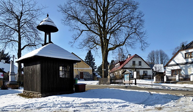
English: "Dřevíkovská" village green, a wooden bell tower, also fulfills the function of a waiting room at the bus stop. In the photo on left the memorial to the victims of the wars 1914-1918 and 1939-1945 and on right the house with a memorial plaque dedicated to teacher and writer, to Czech patriot "František Hrnčíř" (1860–1928). On a tree (linden) above the road is a signpost of the tourist route of the Czech Tourists Club, also a small sacred structure, the so-called God's torture and the information board on the Homeland trail the Region of Chrudimka River (point 10 - "Dřevíkovská" village green). "Dřevíkov" is settlement locality of the type of small hamlet and the name of the cadastral area with an area of 226.58 ha with a range of approximately 534 to 579 meters above sea level in the landscape area of the Iron Mountains, within the administrative is part municipality of Vysočina in the district of Chrudim belonging to the Pardubice Region in the territory of the Czech Republic. Photo location: Czechia, Pardubice Region, municipality Vysočina, hamlet of "Dřevíkov", "Stružinecká" knoll hill.
Čeština: Dřevíkovská náves s dřevěnou zvoničkou (malá stavba slouží současně jako čekárna autobusové zastávky). Vlevo pomník obětem válek 1914–1918 a 1939–1945, vpravo dům s pamětní deskou věnovanou učiteli a spisovateli Františku Hrnčířovi (1860–1928), místnímu rodákovi a českému vlastenci. Na stromu (lípa) nad silnicí je rozcestník zeleně značené turistické trasy Klubu českých turistů (úsek Veselý Kopec – Dřevíkov – Svobodné Hamry), také malá sakrální stavba, tzv. Boží muka a informační tabule vlastivědné stezky Krajem Chrudimky (stanoviště č. 10 s názvem Dřevíkovská náves). Dřevíkov je sídelní lokalita typu vesnice a název katastrálního území o rozloze 226,58 ha s rozsahem poloh přibližně 534 až 579 m n. m. v krajinné oblasti Železných hor, v rámci administrativně správním část obce Vysočina v okrese Chrudim náležejícím do Pardubického kraje na území České republiky. Foto lokace: Česko, Pardubický kraj, obec Vysočina, vesnice Dřevíkov, Stružinecká pahorkatina (190°). |
| Date | |
| Source | Travail personnel |
| Auteur | Josef Kreuz (PEPan) |
| Lieu de la prise de vue | | Voir cet endroit et d’autres images sur : OpenStreetMap |
|---|
Externí odkazy:
- Mapy.cz, turistická mapa (letecký pohled) – Dřevíkov viz
- Obec Vysočina – webové stránky viz
Conditions d’utilisation
Moi, en tant que détenteur des droits d’auteur sur cette œuvre, je la publie sous la licence suivante :
Ce fichier est sous la licence Creative Commons Attribution – Partage dans les Mêmes Conditions 4.0 International.
- Vous êtes libre :
- de partager – de copier, distribuer et transmettre cette œuvre
- d’adapter – de modifier cette œuvre
- Sous les conditions suivantes :
- paternité – Vous devez donner les informations appropriées concernant l'auteur, fournir un lien vers la licence et indiquer si des modifications ont été faites. Vous pouvez faire cela par tout moyen raisonnable, mais en aucune façon suggérant que l’auteur vous soutient ou approuve l’utilisation que vous en faites.
- partage à l’identique – Si vous modifiez, transformez, ou vous basez sur cette œuvre, vous devez distribuer votre contribution sous la même licence ou une licence compatible avec celle de l’original.
Historique du fichier
Cliquer sur une date et heure pour voir le fichier tel qu'il était à ce moment-là.
| Date et heure | Vignette | Dimensions | Utilisateur | Commentaire | |
|---|---|---|---|---|---|
| actuel | 24 février 2018 à 17:14 | | 4 623 × 2 681 (4,52 Mio) | PEPan | User created page with UploadWizard |
Utilisation du fichier
La page suivante utilise ce fichier :
Usage global du fichier
Les autres wikis suivants utilisent ce fichier :
- Utilisation sur cs.wikipedia.org