
Fichier:Civilizations map.png

Fichier d’origine (1 427 × 634 pixels, taille du fichier : 41 kio, type MIME : image/png)
Ce fichier et sa description proviennent de Wikimedia Commons.
Description
| Description |
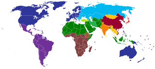
English: A map of civilizations, loosely based (see below) on Huntington's 1996 "Clash of Civilizations" (p. 26).
The NINE "civilizations" identified by Huntington are:
Other colors should indicate (light green, turquoise) the cultural fault lines where the clash of civilizations will occur. There are nine blocks shown in the original 1996 map. The additional colors, including the "fault line" countries in light green or turquoise are due to the judgement of the uploaders/creators of this map, not to Huntington. Other differences from the original map:
Español: Un mapa de civilizaciones, basado libremente (ver abajo) en el "Choque de civilizaciones" de Huntington en 1996 (p.26).
Las NUEVE "civilizaciones" identificadas por Huntington son:
Otros colores deben indicar (verde claro, turquesa) las fallas culturales donde ocurriera el choque de civilizaciones. Hay nueve bloques que se muestran en el mapa original de 1996. Los colores adicionales, incluidos los países de la "línea de falla" en color verde claro o turquesa, se deben a la opinión de los usuarios/creadores de este mapa, no a Huntington. Otras diferencias del mapa original:
Русский: Карта этнокультурного разделения цивилизаций, построенная по концепции Хантингтона.
עברית: תשע ה"ציביליזציות" שזוהו על ידי הנטינגטון הן:
Suomi: Tähän tulee suomenkielinen teksti. A map of civilizations, loosely based (see below) on Huntington's 1996 "Clash of Civilizations" (p. 26).
The NINE "civilizations" identified by Huntington are:
|
| Date | |
| Source | Travail personnel (Usergreatpower) |
| Auteur | Usergreatpower sur Wikipédia anglais |
| Autres versions | File:Clash of Civilizations map.png |
Conditions d’utilisation
| Cette œuvre a été placée dans le domaine public par son auteur, Usergreatpower sur Wikipédia anglais. Ceci s’applique dans le monde entier. Dans certains pays, ceci peut ne pas être possible ; dans ce cas : Usergreatpower accorde à toute personne le droit d’utiliser cette œuvre dans n’importe quel but, sans aucune condition, sauf celles requises par la loi. |
Journal des téléversements d’origine
- 2008-11-20 23:07 Usergreatpower 1427×742× (55694 bytes) {{Information |Description=Clash of Civilisations map |Source=I created this work entirely by myself. |Date=20/11/2008 |Author=~~~ |other_versions= }}
| Annotations | Cette image est annotée : Voir les annotations sur Wikimedia Commons |
Historique du fichier
Cliquer sur une date et heure pour voir le fichier tel qu'il était à ce moment-là.
| Date et heure | Vignette | Dimensions | Utilisateur | Commentaire | |
|---|---|---|---|---|---|
| actuel | 16 mai 2020 à 21:49 | | 1 427 × 634 (41 kio) | Babelia | According to the book, Argentina is Latin American (despite the white majority and the southern European cultural influence) |
| 27 mars 2019 à 06:01 |  | 1 427 × 634 (37 kio) | Enterlousy | Since this is based LOOSELY on "Clash of Civilizations" I made some adjustments. As in the book, Mindanao is Islamic. However, Argentina should be Western, due to heavy Italian, German, and French influence due to immigration. | |
| 25 juillet 2013 à 10:03 |  | 1 427 × 634 (38 kio) | Nikola Štuban | Croatia was in darker blue than the rest of the western world | |
| 19 juillet 2013 à 21:39 |  | 1 427 × 634 (38 kio) | Quite vivid blur | Updated map to include South Sudan, corrections according to Samuel P. Huntington's The Clash of Civilizations. | |
| 9 mai 2013 à 12:27 |  | 1 427 × 634 (50 kio) | Valentinian | Rv one edit. Huntington very expressly assigns Turkey to its own category. | |
| 8 mars 2013 à 12:40 |  | 1 427 × 634 (50 kio) | Maphobbyist | Adjusted the green color for Turkey to the same hue used for Muslim countries. | |
| 14 février 2013 à 02:36 |  | 1 427 × 634 (50 kio) | Yerevanci | since when is Turkey an Orthodox state? | |
| 12 novembre 2012 à 21:58 |  | 1 427 × 742 (54 kio) | Wester | map is based on a book | |
| 16 septembre 2012 à 13:09 |  | 1 427 × 742 (62 kio) | 23prootie~commonswiki | South Sudan is African. | |
| 1 août 2012 à 00:02 |  | 1 427 × 742 (35 kio) | Carnby | Added South Sudan border since this map is based on present day political world map; probably it would have been better to choose a map with the borders of Huntington's times |
Utilisation du fichier
La page suivante utilise ce fichier :
Usage global du fichier
Les autres wikis suivants utilisent ce fichier :
- Utilisation sur ar.wikipedia.org
- Utilisation sur be-tarask.wikipedia.org
- Utilisation sur be.wikipedia.org
- Utilisation sur br.wikipedia.org
- Utilisation sur ca.wikipedia.org
- Utilisation sur ckb.wikipedia.org
- Utilisation sur en.wikipedia.org
- Talk:Persecution of Christians in the post–Cold War era/Archive 1
- Talk:Roman Empire/Archive 7
- Wikipedia:Graphics Lab/Map workshop/Archive/Jun 2012
- User:The Stray Dog
- User talk:Robert McClenon/Archive 13
- User:The Stray Dog/COC
- User talk:Tryptofish/Archive 31
- User talk:KDTW Flyer/Archive 2016
- User:Oshwah/TalkPageArchives/2019-01
- User talk:CAPTAIN RAJU/Archive 68
- Utilisation sur eo.wikipedia.org
- Utilisation sur es.wikipedia.org
- Utilisation sur fa.wikipedia.org
- Utilisation sur fi.wikipedia.org
- Utilisation sur gl.wikipedia.org
- Utilisation sur he.wikipedia.org
- Utilisation sur incubator.wikimedia.org
- Utilisation sur ml.wikipedia.org
- Utilisation sur nl.wikipedia.org
- Utilisation sur pl.wikipedia.org
- Utilisation sur pms.wikipedia.org
- Utilisation sur pt.wikipedia.org
- Utilisation sur ru.wikipedia.org
- Utilisation sur tg.wikipedia.org
- Utilisation sur uz.wikipedia.org