
Fichier:China-Qinghai.png
Pas de plus haute résolution disponible.
China-Qinghai.png (268 × 218 pixels, taille du fichier : 15 kio, type MIME : image/png)
Ce fichier et sa description proviennent de Wikimedia Commons.
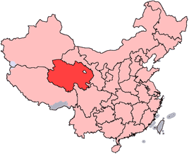
en: Location of Qinghai Province in the People's Republic of China. See Locator maps of province-level divisions of the People's Republic of China for more information.
zh: 青海省在中華人民共和國的位置。另見Locator maps of province-level divisions of the People's Republic of China。

|
Vous avez la permission de copier, distribuer et modifier ce document selon les termes de la GNU Free Documentation License version 1.2 ou toute version ultérieure publiée par la Free Software Foundation, sans sections inaltérables, sans texte de première page de couverture et sans texte de dernière page de couverture. Un exemplaire de la licence est inclus dans la section intitulée GNU Free Documentation License. |
| Ce fichier est disponible selon les termes de la licence Creative Commons Attribution – Partage dans les Mêmes Conditions 3.0 (non transposée). | ||
| ||
| Ce bandeau de licence a été ajouté à ce fichier dans le cadre de la procédure de mise à jour des licences des images sous GFDL. |
Historique du fichier
Cliquer sur une date et heure pour voir le fichier tel qu'il était à ce moment-là.
| Date et heure | Vignette | Dimensions | Utilisateur | Commentaire | |
|---|---|---|---|---|---|
| actuel | 15 juillet 2005 à 16:56 | | 268 × 218 (15 kio) | Schaengel89~commonswiki | transparent background |
| 5 juin 2005 à 00:39 |  | 268 × 218 (9 kio) | Ran | '''en''': Location of Qinghai Province in the People's Republic of China. See Category:Locator maps of province-level divisions of the People's Republic of China for more information. '''zh''': 青海省在中華人民共和國的位置。另見[[:C |
Utilisation du fichier
La page suivante utilise ce fichier :
Usage global du fichier
Les autres wikis suivants utilisent ce fichier :
- Utilisation sur cy.wikipedia.org
- Utilisation sur da.wikipedia.org
- Utilisation sur de.wikipedia.org
- Utilisation sur en.wikipedia.org
- Wikipedia:WikiProject Chinese provinces/Locator maps
- Ledu, Haidong
- Henan Mongol Autonomous County
- Golmud Airport
- Template:Qinghai-geo-stub
- Bayan Har Mountains
- Wenquan, Golmud
- Mangra
- Zêkog County
- Tongren, Qinghai
- Jainca County
- 2008 Tibetan unrest
- Huzhu Tu Autonomous County
- Ping'an, Haidong
- Chengzhong, Xining
- Xireg
- Chengdong, Xining
- Chengbei, Xining
- Datong Hui and Tu Autonomous County
- Huangyuan County
- Huangzhong, Xining
- Hualong Hui Autonomous County
- Haiyan County, Qinghai
- Gangca County
- Menyuan Hui Autonomous County
- Gonghe County
- Tongde County
- Guide County
- Guinan County
- Maqên County
- Banma County
- Gadê County
- Darlag County
- Jigzhi County
- Madoi County
Voir davantage sur l’utilisation globale de ce fichier.