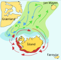
Fichier:Capelin-iceland.svg

Taille de cet aperçu PNG pour ce fichier SVG : 509 × 503 pixels. Autres résolutions : 243 × 240 pixels | 486 × 480 pixels | 777 × 768 pixels | 1 036 × 1 024 pixels | 2 072 × 2 048 pixels.
Fichier d’origine (Fichier SVG, nominalement de 509 × 503 pixels, taille : 93 kio)
Historique du fichier
Cliquer sur une date et heure pour voir le fichier tel qu'il était à ce moment-là.
| Date et heure | Vignette | Dimensions | Utilisateur | Commentaire | |
|---|---|---|---|---|---|
| actuel | 10 mai 2021 à 17:04 |  | 509 × 503 (93 kio) | ActuallyNeverHappened02 | Reverted to version as of 15:40, 21 February 2021 (UTC) |
| 10 mai 2021 à 17:03 |  | 509 × 503 (93 kio) | ActuallyNeverHappened02 | File uploaded using svgtranslate tool (https://svgtranslate.toolforge.org/). Added translation for en. | |
| 21 février 2021 à 17:40 |  | 509 × 503 (93 kio) | ActuallyNeverHappened02 | Reverted to version as of 05:12, 31 July 2006 (UTC) | |
| 21 février 2021 à 17:39 |  | 509 × 503 (92 kio) | ActuallyNeverHappened02 | File uploaded using svgtranslate tool (https://svgtranslate.toolforge.org/). Added translation for en. | |
| 31 juillet 2006 à 07:12 |  | 509 × 503 (93 kio) | Salvor | Capelin school feeding and breeding grounds in the Atlantic ocean around Iceland. based on diagram from Marine Research Institution in Iceland (Hafrannsóknarstofnun) Category:Maps of Iceland Category:Salvör Gissurardóttir [[Category:Created wit | |
| 31 juillet 2006 à 06:50 |  | 509 × 503 (87 kio) | Salvor | Capelin school feeding and breeding grounds in the Atlantic ocean around Iceland. based on diagram from Marine Research Institution in Iceland (Hafrannsóknarstofnun) Category:Maps of Iceland Category:Salvör Gissurardóttir [[Category:Created wit | |
| 31 juillet 2006 à 06:40 |  | 509 × 503 (78 kio) | Salvor | Capelin school feeding and breeding grounds in the Atlantic ocean around Iceland. based on diagram from Marine Research Institution in Iceland (Hafrannsóknarstofnun) Category:Maps of Iceland Category:Salvör Gissurardóttir [[Category:Created wit | |
| 31 juillet 2006 à 06:29 |  | 509 × 503 (76 kio) | Salvor | Capelin school feeding and breeding grounds in the Atlantic ocean around Iceland. based on diagram from Marine Research Institution in Iceland (Hafrannsóknarstofnun) Category:Maps of Iceland Category:Salvör Gissurardóttir [[Category:Created wit |
Utilisation du fichier
Les 2 pages suivantes utilisent ce fichier :
Usage global du fichier
Les autres wikis suivants utilisent ce fichier :
- Utilisation sur de.wikipedia.org
- Utilisation sur en.wikipedia.org
- Utilisation sur en.wikibooks.org
- Utilisation sur es.wikipedia.org
- Utilisation sur gl.wikipedia.org
- Utilisation sur hu.wikipedia.org
- Utilisation sur is.wikipedia.org
- Utilisation sur is.wikibooks.org
- Utilisation sur it.wikipedia.org
- Utilisation sur ja.wikipedia.org
- Utilisation sur nl.wikipedia.org
- Utilisation sur pl.wikipedia.org
- Utilisation sur ru.wikipedia.org
- Utilisation sur vi.wikipedia.org
- Utilisation sur zh.wikipedia.org
