Fichier:Apollo 17 Blue Marble original orientation (AS17-148-22727).jpg

Le contenu de la page n’est pas pris en charge dans d’autres langues.
Une page de Wikipédia, l'encyclopédie libre.

Fichier d’origine(2 400 × 2 400 pixels, taille du fichier : 5,97 Mio, type MIME : image/jpeg)

Ce fichier et sa description proviennent de Wikimedia Commons.

Description

 
Taken with a Hasselblad 500EL camera and 80mm Zeiss lens at stop setting f/2.8 on 70mm Ektachrome film of type SO-368
Description
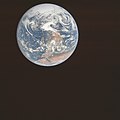
English: NASA original caption: View of the Earth as seen by the Apollo 17 crew on December 7, 1972, traveling toward the moon. This translunar coast photograph extends from the Mediterranean Sea area to the Antarctica south polar ice cap. This is the first time the Apollo trajectory made it possible to photograph the south polar ice cap. Note the heavy cloud cover in the Southern Hemisphere. Almost the entire coastline of Africa is clearly visible. The Arabian Peninsula can be seen at the northeastern edge of Africa. The large island off the east coast of Africa is the Republic of Madagascar. The Asian mainland is on the horizon toward the northeast.
Altitude: Roughly 29,400 km (18,300 miles)
Image center rough coordinates: 17°10'50"N 21°45'19"E
Earth disk center rough coordinates: 26°19’49”S 37°25’13”E
Date UTC
Source http://www.lpi.usra.edu/resources/apollo/frame/?AS17-148-22727 (image link)
Auteur NASA
Autres versions
North-up orientation
Position de l'objet26° 19′ 49″ S, 37° 25′ 13″ E Kartographer map based on OpenStreetMap.Voir cet endroit et d’autres images sur : OpenStreetMapinfo
Cette image ou vidéo a été cataloguée par le
Johnson Space Center
de la
National Aeronautics and Space Administration
(NASA) des États-Unis sous Photo ID : AS17-148-22727.

Ce bandeau n’indique rien sur le statut de l’œuvre au regard du droit d'auteur. Un bandeau de droit d’auteur est requis. Voir Commons:À propos des licences pour plus d’informations.
Autres langues :

Conditions d’utilisation

Public domain Ce fichier provient de la NASA. Sauf exception, les documents créés par la NASA ne sont pas soumis à copyright. Pour plus d'informations, voir la politique de copyright de la NASA.
Attention :

Légendes

Ajoutez en une ligne la description de ce que représente ce fichier
The origin photo of the famous ‘Blue Marble’ image, depicting Earth (with the continents of Antarctica on top and Africa plus the Arabian Peninsula near the bottom) from roughly 29,400 km away, on 7 December 1972 at 10:39 UTC

Éléments décrits dans ce fichier

dépeint

image/jpeg

201af1b4f3be8e2129bc3ba7ff8ebb0c8f041c8c

6 257 204 octet

2 400 pixel

2 400 pixel

26°19'49.001"S, 37°25'13.001"E

Historique du fichier

Cliquer sur une date et heure pour voir le fichier tel qu'il était à ce moment-là.

Date et heureVignetteDimensionsUtilisateurCommentaire
actuel30 octobre 2021 à 10:40Vignette pour la version du 30 octobre 2021 à 10:402 400 × 2 400 (5,97 Mio)HuntsterReverted to version as of 08:21, 6 June 2015 (UTC); the differences are enough that this needs ot be uploaded to a new filename, but no source was given for this new version. Where did this significantly higher resolution come from...just a cleaned up version of File:EarthOverAfrica.jpg?
30 octobre 2021 à 05:27Vignette pour la version du 30 octobre 2021 à 05:274 400 × 4 600 (2,72 Mio)Mistedspectaclehigher resolution & color correction
6 juin 2015 à 10:21Vignette pour la version du 6 juin 2015 à 10:212 400 × 2 400 (5,97 Mio)Huntster{{Information |Description={{en|1=View of the Earth as seen by the Apollo 17 crew on December 7, 1972, traveling toward the moon. This translunar coast photograph extends from the Mediterranean Sea area to the Antarctica south polar ice cap. This is th...

La page suivante utilise ce fichier :

Usage global du fichier

Les autres wikis suivants utilisent ce fichier :

Métadonnées