
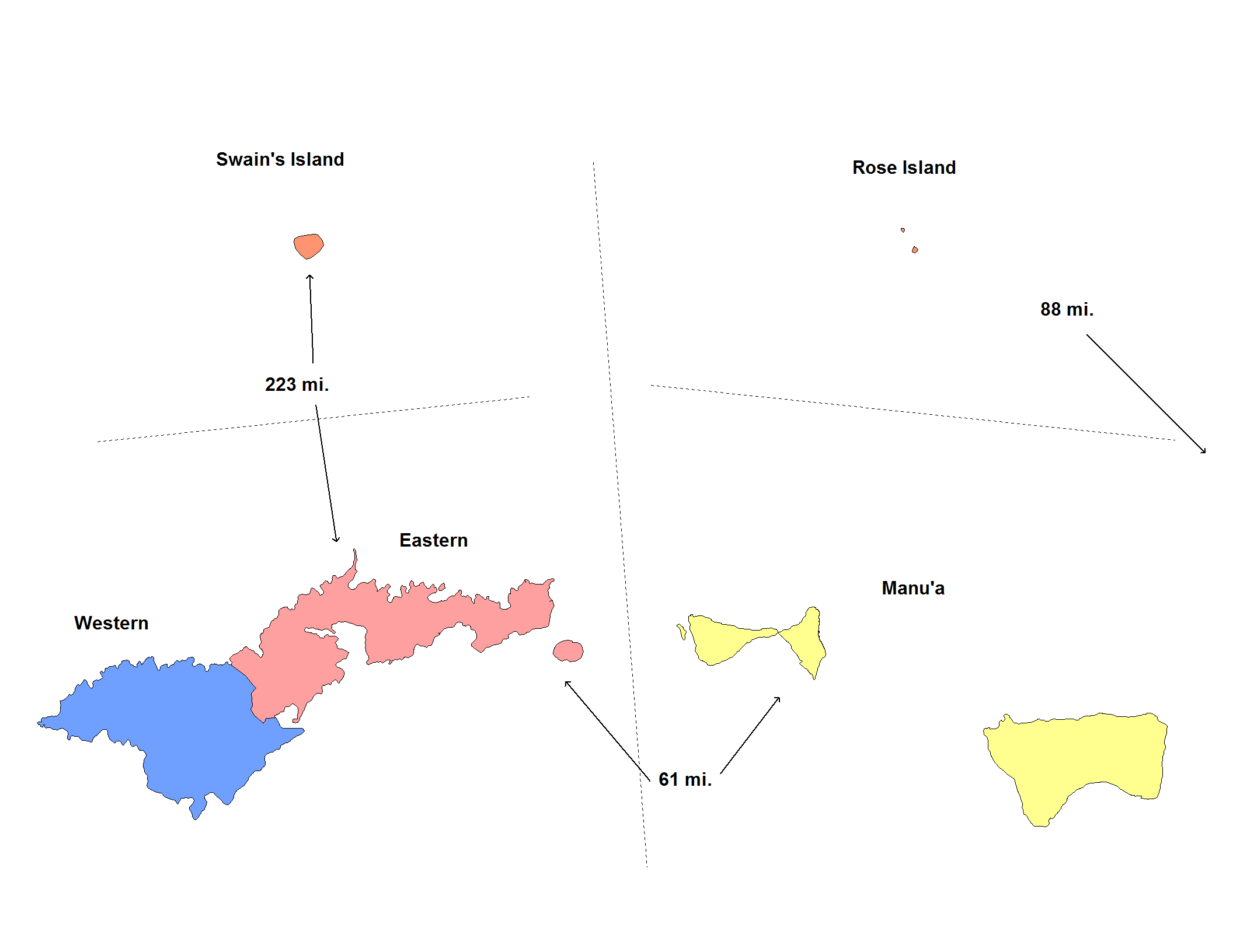
Fichier:American Samoa Districts.png
Taille de cet aperçu : 776 × 600 pixels. Autres résolutions : 311 × 240 pixels | 621 × 480 pixels | 994 × 768 pixels | 1 280 × 989 pixels | 2 112 × 1 632 pixels.
Fichier d’origine (2 112 × 1 632 pixels, taille du fichier : 36 kio, type MIME : image/png)
Ce fichier et sa description proviennent de Wikimedia Commons.

|
Cette image (de type carte) devrait être recréée dans un format vectoriel, en tant que fichier SVG. Cela offrirait plusieurs avantages : voir Commons:Media for cleanup pour plus d'informations. Si une version SVG de cette image est déjà disponible, merci de bien vouloir l'envoyer. Après cela, remplacez ce modèle par {{vector version available|nouveau nom d'image.svg}}.
|
Description
| Description | Map of the districts of American Samoa. Created by Rarelibra for public domain use. Created using MapInfo Professional v7.5 and various mapping resources. |
| Date | 20 novembre 2006 (date de téléversement originale) |
| Source | La source n’a pas pu être reconnue automatiquement. « Travail personnel » supposé (étant donné la revendication de droit d’auteur). |
| Auteur | L’auteur n’a pas pu être identifié automatiquement. Il est supposé qu'il s'agit de : Electionworld (étant donné la revendication de droit d’auteur). |
Conditions d’utilisation
| Moi, propriétaire des droits d’auteur sur cette œuvre, la place dans le domaine public. Ceci s'applique dans le monde entier. Dans certains pays, ceci peut ne pas être possible ; dans ce cas : J’accorde à toute personne le droit d’utiliser cette œuvre dans n’importe quel but, sans aucune condition, sauf celles requises par la loi. |
Historique du fichier
Cliquer sur une date et heure pour voir le fichier tel qu'il était à ce moment-là.
| Date et heure | Vignette | Dimensions | Utilisateur | Commentaire | |
|---|---|---|---|---|---|
| actuel | 1 juin 2020 à 07:14 | | 2 112 × 1 632 (36 kio) | Heitordp | Reverted to version as of 17:42, 11 January 2008 (UTC) keep previous map, many articles refer to its colors and positions |
| 1 juin 2020 à 05:32 | 2 104 × 808 (26 kio) | Heitordp | Removed excessive blank space, removed distances, improved shapes, moved islands to reflect real relative positions, adjusted colors, corrected atoll names, increased font size for legibility in infobox | ||
| 11 janvier 2008 à 19:42 |  | 2 112 × 1 632 (36 kio) | Rarelibra | update map | |
| 21 novembre 2006 à 00:22 |  | 953 × 598 (11 kio) | Electionworld | == Summary == Map of the districts of American Samoa. Created by Rarelibra for public domain use. Created using MapInfo Professional v7.5 and various mapping resources. == Licensing == {{PD-self}} Category:Maps of American Samoa |
Utilisation du fichier
La page suivante utilise ce fichier :
Usage global du fichier
Les autres wikis suivants utilisent ce fichier :
- Utilisation sur de.wikipedia.org
- Utilisation sur en.wikipedia.org
- Utilisation sur eu.wikipedia.org
- Utilisation sur fy.wikipedia.org
- Utilisation sur he.wikipedia.org
- Utilisation sur it.wikipedia.org
- Utilisation sur ja.wikipedia.org
- Utilisation sur ka.wikipedia.org
- Utilisation sur nl.wikipedia.org
- Utilisation sur os.wikipedia.org
- Utilisation sur pt.wikipedia.org
- Utilisation sur ru.wikipedia.org
- Utilisation sur sm.wikipedia.org
- Utilisation sur zh.wikipedia.org