
Fichier:All Saints Church - geograph.org.uk - 1232337.jpg
Pas de plus haute résolution disponible.
All_Saints_Church_-_geograph.org.uk_-_1232337.jpg (640 × 426 pixels, taille du fichier : 80 kio, type MIME : image/jpeg)
Ce fichier et sa description proviennent de Wikimedia Commons.
Description
| Description |
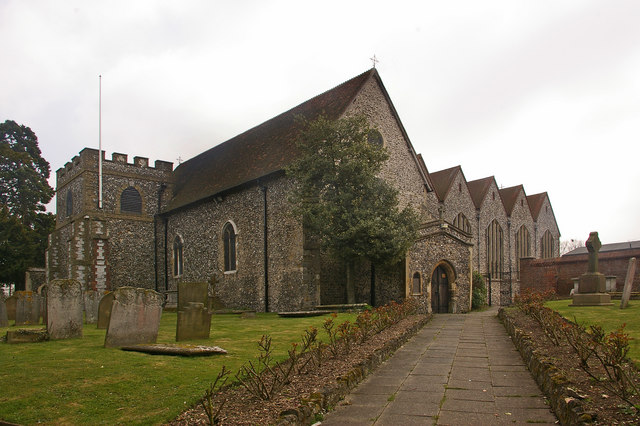
English: All Saints Church This Grade B listed church originally dates from the 12th century, although there are indications of an earlier building here. A tower was added in the 13th century and a porch in the 14th century. For many years it had a taller tower, but this was severely damaged by a storm in 1771, and the subsequent rebuilding was of this shorter castellated version, topped with a steeple. However in 1809 the steeple was struck by lightning and caught fire. It was not replaced, resulting in the present profile of a tower shorter than the surrounding roof.
In 1957, following demolition of Bark Hart House, a Tudor house to the south of the church where Elizabeth I had once stayed, the church was extended over part of the vacated land (the extension can be seen to the right of the photo). For listing particulars see http://www.heritagegateway.org.uk/Gateway/Results_Single.aspx?uid=358379&resourceID=5 |
| Date | |
| Source | From geograph.org.uk |
| Auteur | Ian Capper |
| Attribution (imposé par la licence) | Ian Capper / All Saints Church / |
| Lieu de la prise de vue | | Voir cet endroit et d’autres images sur : OpenStreetMap |
|---|
_heading:157.00&language=fr)
| Position de l'objet | | Voir cet endroit et d’autres images sur : OpenStreetMap |
|---|
_heading:157.00&language=fr)
Conditions d’utilisation

|
Cette image provient de la collection du projet Geograph British Isles. Pour obtenir les coordonnées du photographe, veuillez consulter cette page de description de l'image sur le site du projet. Les droits d'auteurs sur cette image sont détenus par Ian Capper ; l'image est placée sous une licence Creative Commons avec mention de paternité et partage à l'identique (CC-By-SA) en version 2.0.
|
Ce fichier est disponible selon les termes de la licence Creative Commons Attribution – Partage dans les Mêmes Conditions 2.0 Générique
Attribution: Ian Capper
- Vous êtes libre :
- de partager – de copier, distribuer et transmettre cette œuvre
- d’adapter – de modifier cette œuvre
- Sous les conditions suivantes :
- paternité – Vous devez donner les informations appropriées concernant l'auteur, fournir un lien vers la licence et indiquer si des modifications ont été faites. Vous pouvez faire cela par tout moyen raisonnable, mais en aucune façon suggérant que l’auteur vous soutient ou approuve l’utilisation que vous en faites.
- partage à l’identique – Si vous modifiez, transformez, ou vous basez sur cette œuvre, vous devez distribuer votre contribution sous la même licence ou une licence compatible avec celle de l’original.
Historique du fichier
Cliquer sur une date et heure pour voir le fichier tel qu'il était à ce moment-là.
| Date et heure | Vignette | Dimensions | Utilisateur | Commentaire | |
|---|---|---|---|---|---|
| actuel | 26 février 2011 à 14:28 | | 640 × 426 (80 kio) | GeographBot | == {{int:filedesc}} == {{Information |description={{en|1=All Saints Church This Grade B listed church originally dates from the 12th century, although there are indications of an earlier building here. A tower was added in the 13th century and a porch in |
Utilisation du fichier
La page suivante utilise ce fichier :
Usage global du fichier
Les autres wikis suivants utilisent ce fichier :
- Utilisation sur en.wikipedia.org
- Utilisation sur pl.wikipedia.org