
Fichier:AlgodonesDunes ISS011-E-11543.jpg

Taille de cet aperçu : 800 × 531 pixels. Autres résolutions : 320 × 212 pixels | 640 × 424 pixels | 1 024 × 679 pixels | 1 280 × 849 pixels | 3 040 × 2 016 pixels.
Fichier d’origine (3 040 × 2 016 pixels, taille du fichier : 3,24 Mio, type MIME : image/jpeg)
Ce fichier et sa description proviennent de Wikimedia Commons.
Description
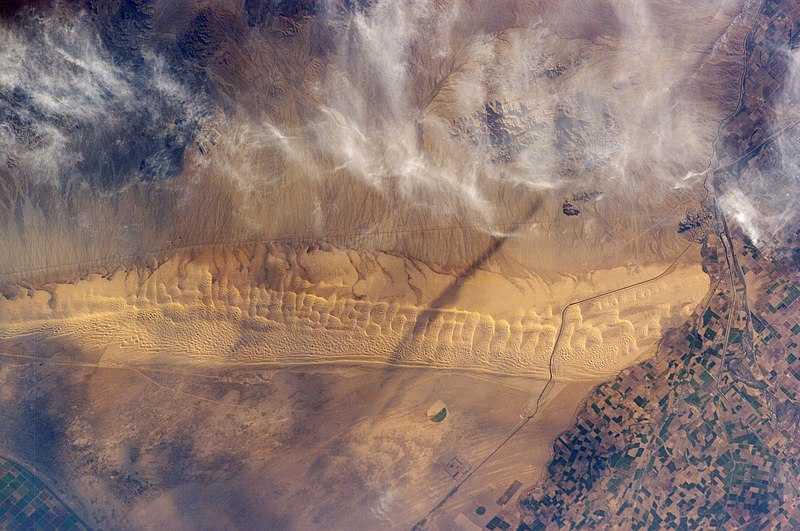
| Description | Astronaut photo of the Algodones Dunes, at the borders of California, Arizona, and Mexico. The All-American Canal cuts across the southern end of the dunes and the Cargo Muchacho Mountains can be seen beneath cloud cover at the top of the scene. Remains of the Alamo Canal are located parallel to the left side of the Colorado River (center far right of image), with the intake still visible near Pilot Knob. |
| Date | |
| Source | http://earthobservatory.nasa.gov/Newsroom/NewImages/images.php3?img_id=17098 |
| Auteur | ISS Crew Earth Observations experiment and the Image Science & Analysis Group, Johnson Space Center. Image cleaned up by NASA Earth Observatory |
| Autorisation (Réutilisation de ce fichier) |
US government, public domain |
| Lieu de la prise de vue | | Voir cet endroit et d’autres images sur : OpenStreetMap |
|---|
Conditions d’utilisation
"The Gateway to Astronaut Photography of Earth". Image provenant du Laboratoire d'Analyse et d'Imagerie des Sciences, Centre Spatial Johnson de la NASA.
Source de la photo : ISS011-E-11543.
|
| Annotations | Cette image est annotée : Voir les annotations sur Wikimedia Commons |
Historique du fichier
Cliquer sur une date et heure pour voir le fichier tel qu'il était à ce moment-là.
| Date et heure | Vignette | Dimensions | Utilisateur | Commentaire | |
|---|---|---|---|---|---|
| actuel | 25 mai 2013 à 04:48 | | 3 040 × 2 016 (3,24 Mio) | Ras67 | new rendered in high resolution from NASA's raw image data |
| 2 mai 2006 à 01:32 |  | 1 000 × 662 (459 kio) | Holly Cheng | {{Information | Description=Astronaut photo of the w:Algodones Dunes, at the borders of California, Arizona, and Mexico. The w:All-American Canal cuts across the southern end of the dunes and the w:Cargo Muchacho Mountains can be seen beneath |
Utilisation du fichier
La page suivante utilise ce fichier :
Usage global du fichier
Les autres wikis suivants utilisent ce fichier :
- Utilisation sur arz.wikipedia.org
- Utilisation sur ceb.wikipedia.org
- Utilisation sur de.wikipedia.org
- Utilisation sur en.wikipedia.org
- Utilisation sur en.wikivoyage.org
- Utilisation sur es.wikipedia.org
- Utilisation sur ja.wikipedia.org
- Utilisation sur lld.wikipedia.org
- Utilisation sur sv.wikipedia.org
- Utilisation sur www.wikidata.org