
Fichier:2008 Pacific typhoon season summary.png

Taille de cet aperçu : 800 × 600 pixels. Autres résolutions : 320 × 240 pixels | 640 × 480 pixels | 1 024 × 768 pixels | 1 280 × 960 pixels | 2 560 × 1 920 pixels | 4 000 × 3 000 pixels.
Fichier d’origine (4 000 × 3 000 pixels, taille du fichier : 7,61 Mio, type MIME : image/png)
Ce fichier et sa description proviennent de Wikimedia Commons.
Description
| Description |
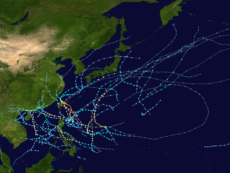
English: This map shows the tracks of all tropical cyclones in the 2008 Pacific typhoon season. The points show the location of each storm at 6-hour intervals. The colour represents the storm's maximum sustained wind speeds as classified in the Saffir-Simpson Hurricane Scale (see below), and the shape of the data points represent the type of the storm.
Tropical depression (≤38 mph, ≤62 km/h)
Tropical storm (39–73 mph, 63–118 km/h)
Category 1 (74–95 mph, 119–153 km/h)
Category 2 (96–110 mph, 154–177 km/h)
Category 3 (111–129 mph, 178–208 km/h)
Category 4 (130–156 mph, 209–251 km/h)
Category 5 (≥157 mph, ≥252 km/h)
Unknown
Storm type |
| Source | Created using Wikipedia:WikiProject Tropical cyclones/Tracks. The background image is from NASA [1]. The tracking data is from the Joint Typhoon Warning Center's best track database |
| Auteur | Supportstorm |
| Cette œuvre a été placée dans le domaine public par son auteur, Supportstorm. Ceci s’applique dans le monde entier. Dans certains pays, ceci peut ne pas être possible ; dans ce cas : Supportstorm accorde à toute personne le droit d’utiliser cette œuvre dans n’importe quel but, sans aucune condition, sauf celles requises par la loi. |
Historique du fichier
Cliquer sur une date et heure pour voir le fichier tel qu'il était à ce moment-là.
| Date et heure | Vignette | Dimensions | Utilisateur | Commentaire | |
|---|---|---|---|---|---|
| actuel | 22 juillet 2020 à 05:09 | | 4 000 × 3 000 (7,61 Mio) | Supportstorm | {{Hurricane season auto track map|start=2008-01-12|end=2008-12-18|source=JTWC|type=typhoon|basin=Pacific|year=2008|author=Supportstorm}} |
Utilisation du fichier
La page suivante utilise ce fichier :
Usage global du fichier
Les autres wikis suivants utilisent ce fichier :
- Utilisation sur de.wikipedia.org
- Utilisation sur en.wikipedia.org
- 2008 Pacific typhoon season
- Tropical Storm Mekkhala (2008)
- Typhoon Neoguri (2008)
- Timeline of the 2008 Pacific typhoon season
- Typhoon Fengshen
- Template:2008 Pacific typhoon season buttons
- Typhoon Kalmaegi (2008)
- Tropical Storm Halong (2008)
- Typhoon Fung-wong (2008)
- Tropical Storm Kammuri (2008)
- Typhoon Rammasun (2008)
- Typhoon Nuri (2008)
- Typhoon Sinlaku (2008)
- Typhoon Hagupit (2008)
- Typhoon Jangmi (2008)
- Tropical Storm Maysak (2008)
- Typhoon Dolphin (2008)
- Tropical Storm Higos (2008)
- User:Typhoon2013/2008 Pacific typhoon season
- User:Tfmbty/2008 Pacific typhoon season
- Tropical cyclones in 2008
- Utilisation sur ja.wikipedia.org
- Utilisation sur ko.wikipedia.org
- Utilisation sur nl.wikipedia.org
- Utilisation sur pt.wikipedia.org
- Utilisation sur tl.wikipedia.org
- Utilisation sur vi.wikipedia.org
- Utilisation sur www.wikidata.org
- Utilisation sur zh.wikipedia.org