
Fichier:1945-08-01JapWW2BattlefrontAtlas-arrow.jpg
Pas de plus haute résolution disponible.
1945-08-01JapWW2BattlefrontAtlas-arrow.jpg (595 × 591 pixels, taille du fichier : 81 kio, type MIME : image/jpeg)
Ce fichier et sa description proviennent de Wikimedia Commons.
Description
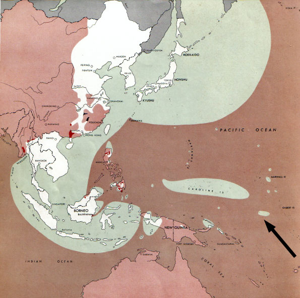
| Description |
  July 1, 1943 to June 30 1945 To the Secretary of War". (See Cover, Forward and Map details)  |
| Date | |
| Source | Document "Atlas of the World Battle Fronts in Semimonthly Phases to August 15th 1945: Supplement to The Biennial report of the Chief of Staff of the United States Army July 1, 1943 to June 30 1945 To the Secretary of War" |
| Auteur | Army Map Service |
| Autorisation (Réutilisation de ce fichier) |
Public Domain: Work of US army |
| Autres versions |
|
Category:Nauru in World War II
Conditions d’utilisation
Cette image est une œuvre d'un soldat ou d'un employé de l'U.S. Army, réalisée dans le cadre de ses activités professionnelles. En tant qu'œuvre du gouvernement fédéral des États-Unis d'Amérique, cette image fait partie du domaine public.
|
 |
Historique du fichier
Cliquer sur une date et heure pour voir le fichier tel qu'il était à ce moment-là.
| Date et heure | Vignette | Dimensions | Utilisateur | Commentaire | |
|---|---|---|---|---|---|
| actuel | 13 septembre 2010 à 09:42 | 595 × 591 (81 kio) | Kimdime | changing arrow | |
| 12 septembre 2010 à 15:14 | 595 × 812 (117 kio) | Kimdime | recentred | ||
| 12 septembre 2010 à 11:33 | 842 × 595 (89 kio) | Kimdime | recentred version | ||
| 12 septembre 2010 à 03:35 | 842 × 595 (94 kio) | Kimdime | == {{int:filedesc}} == {{Information |Description= thumb|left|75pxthumb|right|75pxMap of the front against Japan as of 1 Aug 1945: This map is taken from the source "Atlas of |
Utilisation du fichier
La page suivante utilise ce fichier :
Usage global du fichier
Les autres wikis suivants utilisent ce fichier :
- Utilisation sur de.wikipedia.org
- Utilisation sur ru.wikipedia.org