
Fichier:Morrison Formation Brachiosauridae map.png

Taille de cet aperçu : 627 × 600 pixels. Autres résolutions : 251 × 240 pixels | 502 × 480 pixels | 803 × 768 pixels | 1 071 × 1 024 pixels | 2 540 × 2 429 pixels.
Fichier d’origine (2 540 × 2 429 pixels, taille du fichier : 73 kio, type MIME : image/png)
Ce fichier et sa description proviennent de Wikimedia Commons.
Description
| Description |
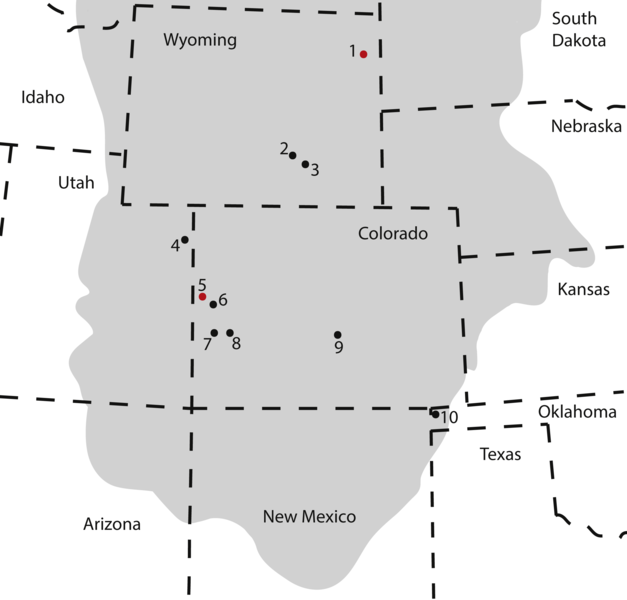
Map of occurrences of Brachiosauridae in the Upper Jurassic Morrison Formation. The locality of the pes described herein (1) and the type locality of Brachiosaurus altithorax (5) are highlighted in red. The gray area indicates the distribution of the Morrison Formation. 1, Bobcat Pit, Weston County, WY; 2, Freezeout Hills general, Carbon Co., WY; 3, Reed’s Quarry 13, Albany Co., WY; 4, Jensen/Jensen Quarry, Uintah Co., UT; 5, Fruita Paleontological Area general, Mesa Co., CO; 6, Riggs Quarry 13, Mesa Co., CO; 7, Dry Mesa Quarry, Mesa Co., CO; 8, Potter Creek Quarry, Montrose Co., CO; 9, Felch Quarry 1, Fremont Co., CO; 10, Kenton Pit 1, Cimarron Co., OK. Modified from Bonnan & Wedel (2004: fig. 2). |
| Date | |
| Source | https://peerj.com/articles/5250/ |
| Auteur | Anthony Maltese, Emanuel Tschopp, Femke Holwerda, David Burnham |
| Autorisation (Réutilisation de ce fichier) |
https://peerj.com/articles/5250.pdf |
Conditions d’utilisation
Ce fichier est disponible selon les termes de la licence Creative Commons Attribution 4.0 International.
- Vous êtes libre :
- de partager – de copier, distribuer et transmettre cette œuvre
- d’adapter – de modifier cette œuvre
- Sous les conditions suivantes :
- paternité – Vous devez donner les informations appropriées concernant l'auteur, fournir un lien vers la licence et indiquer si des modifications ont été faites. Vous pouvez faire cela par tout moyen raisonnable, mais en aucune façon suggérant que l’auteur vous soutient ou approuve l’utilisation que vous en faites.
Cette image, qui provient de https://peerj.com/articles/5250/, a été vérifiée le 24 juillet 2018 par le relecteur Guanaco, qui a confirmé qu'à cette date, elle était disponible sous les termes de cette licence.
|
Historique du fichier
Cliquer sur une date et heure pour voir le fichier tel qu'il était à ce moment-là.
| Date et heure | Vignette | Dimensions | Utilisateur | Commentaire | |
|---|---|---|---|---|---|
| actuel | 10 août 2018 à 19:09 | | 2 540 × 2 429 (73 kio) | HerrAdams | Cropped 1 % horizontally, 1 % vertically using CropTool with precise mode. Removed border. |
| 24 juillet 2018 à 22:17 |  | 2 571 × 2 460 (111 kio) | FunkMonk | == {{int:filedesc}} == {{Information |description=Map of occurrences of Brachiosauridae in the Upper Jurassic Morrison Formation. The locality of the pes described herein (1) and the type locality of Brachiosaurus altithorax (5) are highlighted in red. The gray area indicates the distribution of the Morrison Formation. 1, Bobcat Pit, Weston County, WY; 2, Freezeout Hills general, Carbon Co., WY; 3, Reed’s Quarry 13, Albany Co., WY; 4, Jensen/Jensen Quarry, Uintah Co., UT; 5, Fruita Paleontolo... |
Utilisation du fichier
Aucune page n’utilise ce fichier.
Usage global du fichier
Les autres wikis suivants utilisent ce fichier :
- Utilisation sur ar.wikipedia.org
- Utilisation sur ast.wikipedia.org
- Utilisation sur bg.wikipedia.org
- Utilisation sur ca.wikipedia.org
- Utilisation sur cs.wikipedia.org
- Utilisation sur en.wikipedia.org
- Utilisation sur eu.wikipedia.org
- Utilisation sur he.wikipedia.org
- Utilisation sur hr.wikipedia.org
- Utilisation sur hu.wikipedia.org
- Utilisation sur mk.wikipedia.org
- Utilisation sur nn.wikipedia.org
- Utilisation sur pl.wikipedia.org
- Utilisation sur sv.wikipedia.org
- Utilisation sur tr.wikipedia.org
- Utilisation sur www.wikidata.org
- Utilisation sur zh.wikipedia.org