
Fichier:Map of the Black Sea with bathymetry and surrounding relief.svg

Taille de cet aperçu PNG pour ce fichier SVG : 800 × 508 pixels. Autres résolutions : 320 × 203 pixels | 640 × 406 pixels | 1 024 × 650 pixels | 1 280 × 812 pixels | 2 560 × 1 625 pixels | 1 013 × 643 pixels.
Fichier d’origine (Fichier SVG, nominalement de 1 013 × 643 pixels, taille : 8,35 Mio)
Ce fichier et sa description proviennent de Wikimedia Commons.
Description
| Description |
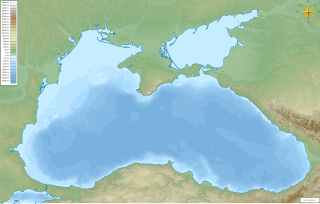
English: Map of the w:Black Sea with bathymetry and surrounding relief.
ქართული: შავი ზღვის რუკა სიღრმის მაჩვენებლებითა და მიდამოების რელიეფით.
Mercator projection. Geographic limits of the map:
|
| Date | |
| Source | Travail personnel |
| Auteur | Giorgi Balakhadze |
Conditions d’utilisation
Giorgi Balakhadze sur Wikipédia anglais, en tant que détenteur des droits d’auteur sur cette œuvre, la publie sous la licence suivante :
Ce fichier est sous la licence Creative Commons Attribution – Partage dans les Mêmes Conditions 4.0 International.
Attribution: Giorgi Balakhadze sur Wikipédia anglais
- Vous êtes libre :
- de partager – de copier, distribuer et transmettre cette œuvre
- d’adapter – de modifier cette œuvre
- Sous les conditions suivantes :
- paternité – Vous devez donner les informations appropriées concernant l'auteur, fournir un lien vers la licence et indiquer si des modifications ont été faites. Vous pouvez faire cela par tout moyen raisonnable, mais en aucune façon suggérant que l’auteur vous soutient ou approuve l’utilisation que vous en faites.
- partage à l’identique – Si vous modifiez, transformez, ou vous basez sur cette œuvre, vous devez distribuer votre contribution sous la même licence ou une licence compatible avec celle de l’original.
Journal des téléversements d’origine
La page de description originale était ici. Tous les noms d'utilisateur qui suivent se rapportent à en.wikipedia.
| Date et heure | Dimensions | Utilisateur | Commentaire |
|---|---|---|---|
| 2016-06-21 15:17:32 | 1013× 643× | Giorgi Balakhadze | fix |
| 2016-06-21 15:12:26 | 1013× 643× | Giorgi Balakhadze | {{Information |Description={{en|Map of the [[Black Sea]] with bathymetry and surrounding relief.}} </br>Mercator projection. Geographic limits of the map: * N: 47.594° N * S: 40.548° N * W: 26.825° E * E: 42.242° E *SRTM WED 3-arc second *ETOPO1 Be... |
Historique du fichier
Cliquer sur une date et heure pour voir le fichier tel qu'il était à ce moment-là.
| Date et heure | Vignette | Dimensions | Utilisateur | Commentaire | |
|---|---|---|---|---|---|
| actuel | 23 juin 2016 à 05:49 | | 1 013 × 643 (8,35 Mio) | OgreBot | (BOT): Reverting to most recent version before archival |
| 23 juin 2016 à 05:49 |  | 1 013 × 643 (8,29 Mio) | OgreBot | (BOT): Uploading old version of file from en.wikipedia; originally uploaded on 2016-06-21 15:12:26 by Giorgi Balakhadze | |
| 22 juin 2016 à 01:13 |  | 1 013 × 643 (8,35 Mio) | FastilyClone | Transferred from en.wikipedia (MTC!) |
Utilisation du fichier
Aucune page n’utilise ce fichier.
Usage global du fichier
Les autres wikis suivants utilisent ce fichier :
- Utilisation sur ar.wikipedia.org
- Utilisation sur azb.wikipedia.org
- Utilisation sur bh.wikipedia.org
- Utilisation sur bn.wikipedia.org
- Utilisation sur da.wiktionary.org
- Utilisation sur en.wikipedia.org
- Black Sea
- Trabzon
- Sea of Azov
- Burgas
- Varna, Bulgaria
- Battle of Varna
- Snake Island (Ukraine)
- Krasnodar
- Kuban (river)
- Maykop
- Pantikapaion
- Samsun
- Battle of Sinop
- Perekop
- Black Sea deluge hypothesis
- Anapa
- Sudak
- Gelendzhik
- Tuapse
- Scythian Neapolis
- Pitsunda
- Ordu
- Battle of Tzirallum
- Battle of Mount Scorobas
- Siege of Varna
- Kaçkar Mountains
- Krasnoperekopsk
- Battle of Adamclisi
- Batumi International Airport
- Kacha, Sevastopol
- Siege of Constantinople (626)
- Siege of Varna (1201)
- Dolgaya Spit
- Danube Canyon
Voir davantage sur l’utilisation globale de ce fichier.