
Fichier:Lake District National Park UK relief location map.png
Taille de cet aperçu : 494 × 600 pixels. Autres résolutions : 198 × 240 pixels | 395 × 480 pixels | 632 × 768 pixels | 843 × 1 024 pixels | 2 001 × 2 430 pixels.
Fichier d’origine (2 001 × 2 430 pixels, taille du fichier : 3,62 Mio, type MIME : image/png)
Ce fichier et sa description proviennent de Wikimedia Commons.
| Description |
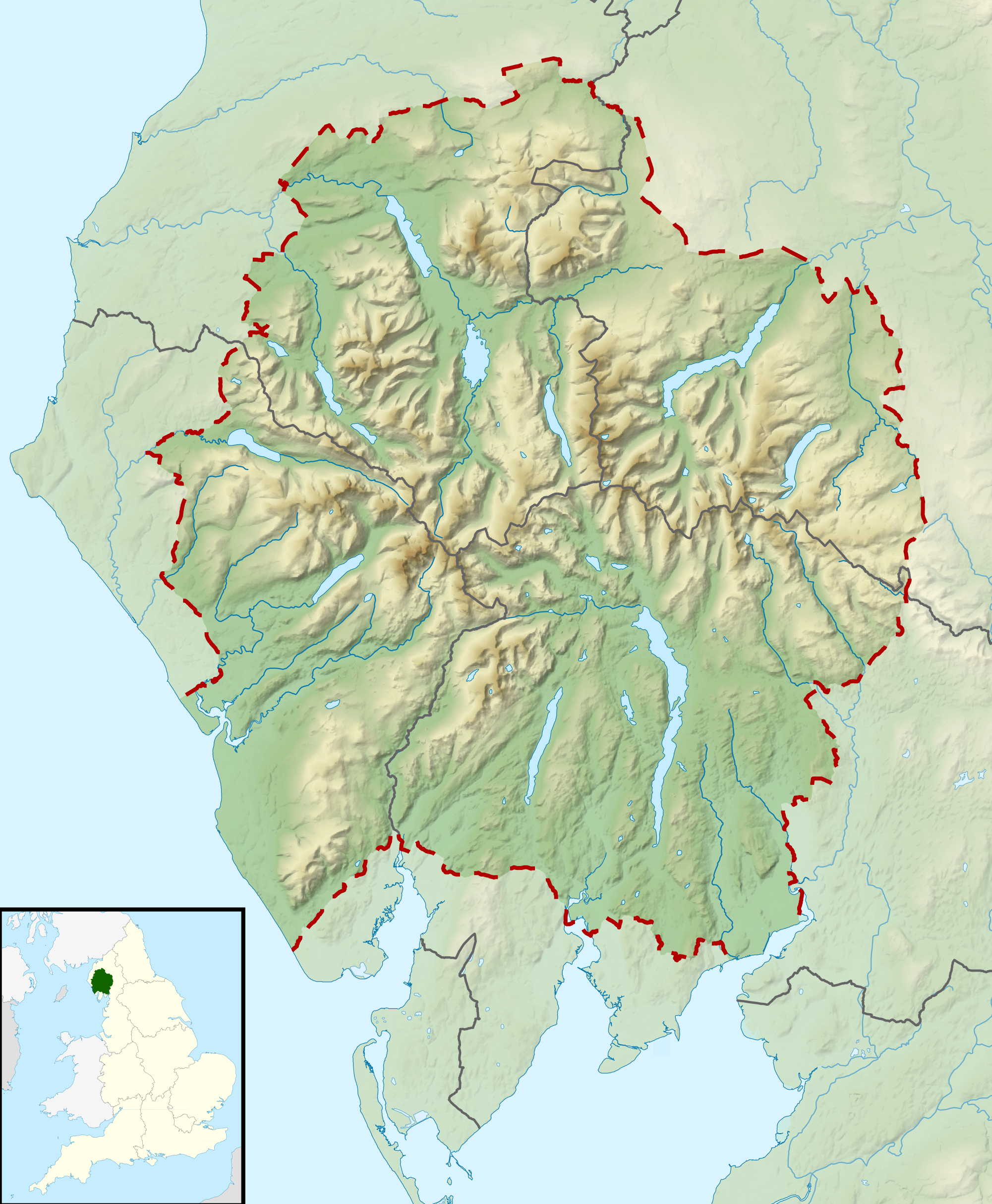
Relief map of the Lake District National Park, UK Equirectangular map projection on WGS 84 datum, with N/S stretched 170% Geographic limits:
|
| Date | |
| Source |
Office of National Statistics Geography
|
| Auteur | Nilfanion, created using Ordnance Survey data |
| Autorisation (Réutilisation de ce fichier) |
Ce fichier est disponible selon les termes de la licence Creative Commons Attribution – Partage dans les Mêmes Conditions 3.0 (non transposée). Attribution: Contains Ordnance Survey data © Crown copyright and database right
|
Historique du fichier
Cliquer sur une date et heure pour voir le fichier tel qu'il était à ce moment-là.
| Date et heure | Vignette | Dimensions | Utilisateur | Commentaire | |
|---|---|---|---|---|---|
| actuel | 17 mars 2012 à 12:51 | | 2 001 × 2 430 (3,62 Mio) | Nilfanion | {{Information |Description=Relief map of the Lake District National Park, UK Equirectangular map projection on WGS 84 datum, with N/S stretched 170% Geographic limits: *West: 3.65W *East: 2.60W *North: 54.80N *South: 54.05N |Sourc... |
Utilisation du fichier
Aucune page n’utilise ce fichier.
Usage global du fichier
Les autres wikis suivants utilisent ce fichier :
- Utilisation sur ar.wikipedia.org
- Utilisation sur ceb.wikipedia.org
- Utilisation sur de.wikivoyage.org
- Utilisation sur en.wikipedia.org
- Lake District
- Derwentwater
- Scafell Pike
- Windermere
- Coniston Water
- Scafell
- Helvellyn
- Wast Water
- Thirlmere
- Skiddaw
- List of lakes of the Lake District
- Bassenthwaite Lake
- Ullswater
- Buttermere
- Old Man of Coniston
- Dent (fell)
- Pillar (Lake District)
- Great Gable
- Bowfell
- Fairfield (Lake District)
- Great End
- Catstye Cam
- Blencathra
- Skiddaw Little Man
- Crinkle Crags
- Haweswater Reservoir
- Ennerdale Water
- Castlerigg stone circle
- Hard Knott
- Harter Fell (Eskdale)
- Whitbarrow
- Great Dodd
- High Street (Lake District)
- Pavey Ark
- Dale Head
- Robinson (Lake District)
- Place Fell
- Little Mell Fell
- Grayrigg Forest
- Hallin Fell
- Grasmoor
- Cold Pike
- Gummer's How
- Whitfell
- High Raise (Langdale)
- Kirkby Moor
- Cat Bells
Voir davantage sur l’utilisation globale de ce fichier.