
Fichier:Harrat Khaybar Space.jpg
Taille de cet aperçu : 800 × 529 pixels. Autres résolutions : 320 × 212 pixels | 640 × 423 pixels | 1 024 × 677 pixels | 1 280 × 846 pixels | 3 032 × 2 005 pixels.
Fichier d’origine (3 032 × 2 005 pixels, taille du fichier : 1,86 Mio, type MIME : image/jpeg)
Ce fichier et sa description proviennent de Wikimedia Commons.
Description
| Description |
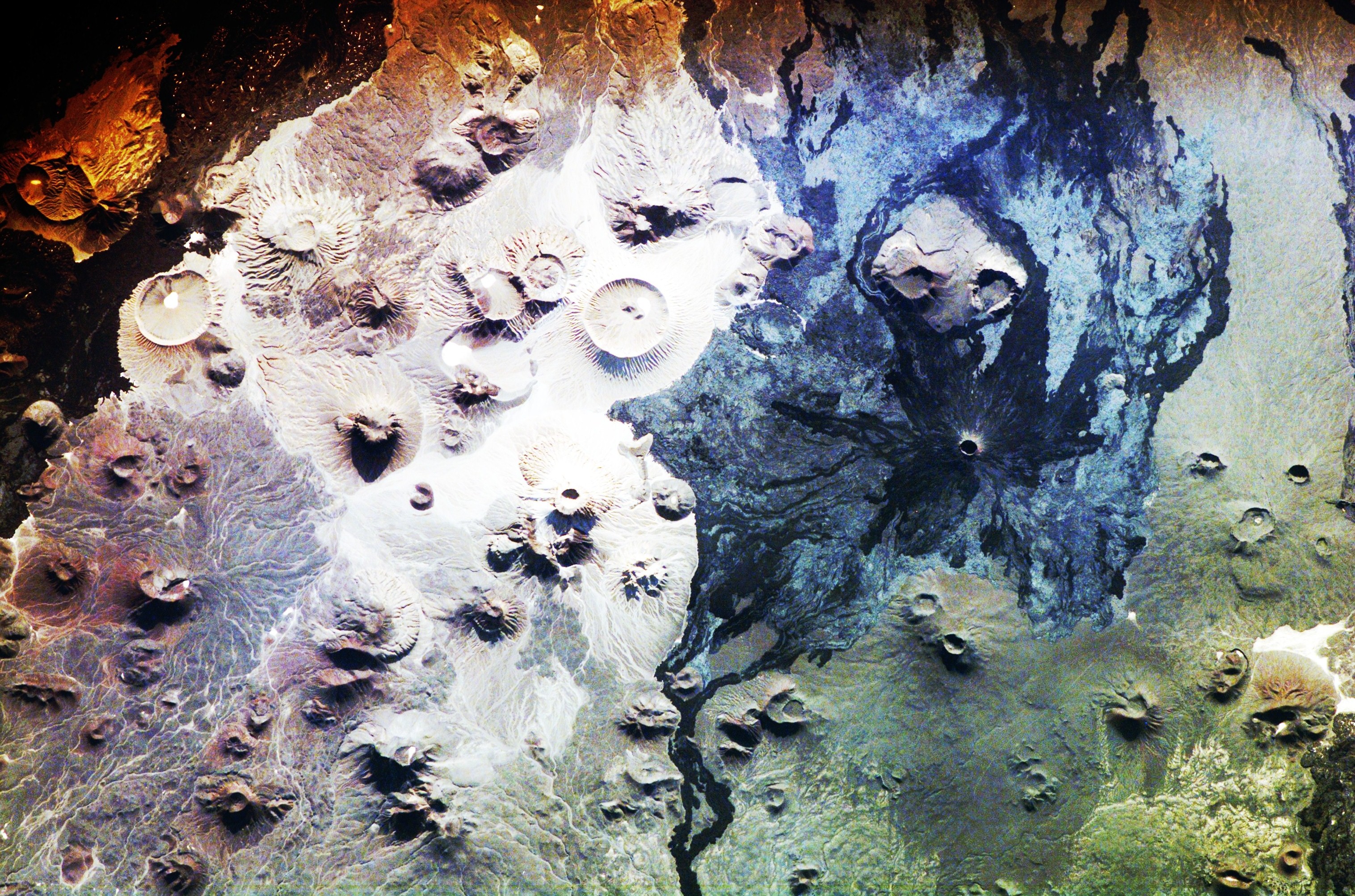
English: Satellite image of Harrat Khaybar volcanic field
|
| Date | |
| Source | NASA Johnson Space Center (direct link) |
| Auteur | Expedition 16 Crew Member on the International Space Station, NASA |
Cette image ou vidéo a été cataloguée par le Johnson Space Center de la National Aeronautics and Space Administration (NASA) des États-Unis sous Photo ID : ISS016-E-034524.Ce bandeau n’indique rien sur le statut de l’œuvre au regard du droit d'auteur. Un bandeau de droit d’auteur est requis. Voir Commons:À propos des licences pour plus d’informations. Autres langues :
|
Conditions d’utilisation
"The Gateway to Astronaut Photography of Earth". Image provenant du Laboratoire d'Analyse et d'Imagerie des Sciences, Centre Spatial Johnson de la NASA.
Source de la photo : ISS016-E-34524.
|
| Annotations | Cette image est annotée : Voir les annotations sur Wikimedia Commons |
Historique du fichier
Cliquer sur une date et heure pour voir le fichier tel qu'il était à ce moment-là.
| Date et heure | Vignette | Dimensions | Utilisateur | Commentaire | |
|---|---|---|---|---|---|
| actuel | 24 novembre 2010 à 16:25 | | 3 032 × 2 005 (1,86 Mio) | Originalwana | correct white balance |
| 3 juin 2009 à 17:19 |  | 3 032 × 2 064 (1 016 kio) | Av9 | {{Information |Description={{en|1=Satellite image of Harrat Khaybar volcanic field}} |Source=NASA Johnson Space Center. http://spaceflight.nasa.gov/gallery/images/station/crew-16/hires/iss016e034524.jpg |Author=Expedition 16 Crew Membe on the Internationa |
Utilisation du fichier
Aucune page n’utilise ce fichier.
Usage global du fichier
Les autres wikis suivants utilisent ce fichier :
- Utilisation sur ar.wikipedia.org
- Utilisation sur arz.wikipedia.org
- Utilisation sur cs.wikipedia.org
- Utilisation sur de.wikipedia.org
- Utilisation sur en.wikipedia.org
- Utilisation sur fa.wikipedia.org
- Utilisation sur lld.wikipedia.org
- Utilisation sur ml.wikipedia.org
- Utilisation sur nn.wikipedia.org
- Utilisation sur sl.wikipedia.org
- Utilisation sur th.wikipedia.org
- Utilisation sur tr.wikipedia.org
- Utilisation sur tum.wikipedia.org
- Utilisation sur www.wikidata.org