
Fichier:England AONBs map.svg

Taille de cet aperçu PNG pour ce fichier SVG : 494 × 599 pixels. Autres résolutions : 198 × 240 pixels | 396 × 480 pixels | 633 × 768 pixels | 844 × 1 024 pixels | 1 688 × 2 048 pixels | 512 × 621 pixels.
Fichier d’origine (Fichier SVG, nominalement de 512 × 621 pixels, taille : 1,92 Mio)
Ce fichier et sa description proviennent de Wikimedia Commons.
Description
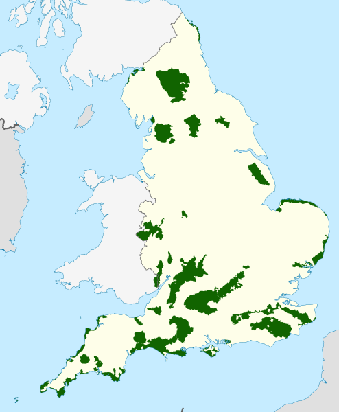
| Description | Map showing all of the Areas of Outstanding Natural Beauty of England, in the United Kingdom. |
| Date | |
| Source |
Ordnance Survey OSOpenData Boundary-Line:
Natural England UK Government (Defra)–Natural England
|
| Auteur |
Dank · Jay, using Ordnance Survey, and Natural England data. Cette image vectorielle contient des éléments, éventuellement modifiés, qui ont été extraits de : Cette image vectorielle contient des éléments, éventuellement modifiés, qui ont été extraits de : Cette image vectorielle contient des éléments, éventuellement modifiés, qui ont été extraits de : |
| Autorisation (Réutilisation de ce fichier) |
Ce fichier est disponible selon les termes de la licence Creative Commons Attribution – Partage dans les Mêmes Conditions 3.0 (non transposée). Attribution: © Natural England copyright 2021. Contains Ordnance Survey data © Crown copyright and database right 2021
|
| Autres versions | Wales AONBs; Northern Ireland AONBs; UK AONBs |
Historique du fichier
Cliquer sur une date et heure pour voir le fichier tel qu'il était à ce moment-là.
| Date et heure | Vignette | Dimensions | Utilisateur | Commentaire | |
|---|---|---|---|---|---|
| actuel | 13 octobre 2021 à 19:22 | | 512 × 621 (1,92 Mio) | DankJae | Added the Wye Valley parts in Wales |
| 13 octobre 2021 à 19:15 |  | 512 × 621 (1,91 Mio) | DankJae | Uploaded own work with UploadWizard |
Utilisation du fichier
Aucune page n’utilise ce fichier.
Usage global du fichier
Les autres wikis suivants utilisent ce fichier :
- Utilisation sur en.wikipedia.org
- Cornwall
- Cotswolds
- Suffolk & Essex Coast & Heaths National Landscape
- Area of Outstanding Natural Beauty
- Cannock Chase
- Quantock Hills
- Mendip Hills
- Chiltern Hills
- Forest of Bowland
- Isle of Wight National Landscape
- Malvern Hills
- North Wessex Downs
- Lincolnshire Wolds
- North Pennines
- Kent Downs
- Blackdown Hills National Landscape
- Shropshire Hills National Landscape
- High Weald National Landscape
- Chichester Harbour
- Howardian Hills
- Surrey Hills National Landscape
- Nidderdale National Landscape
- Lindfield, West Sussex
- Dedham Vale National Landscape
- Arnside and Silverdale National Landscape
- Wye Valley
- North Devon Coast
- East Devon National Landscape
- Tamar Valley National Landscape
- Template:AONBs in England
- South Devon National Landscape
- Solway Coast
- Northumberland Coast National Landscape
- Cranborne Chase and West Wiltshire Downs
- Norfolk Coast National Landscape
- East Hampshire AONB
- South Hampshire Coast
- Isles of Scilly
- Sussex Downs AONB
- User:Karmstro/Sandbox
- Cornwall National Landscape