
Fichier:View of Vicksburg.jpg
Fichier d’origine (6 552 × 5 024 pixels, taille du fichier : 4,94 Mio, type MIME : image/jpeg)
Ce fichier et sa description proviennent de Wikimedia Commons.
Description
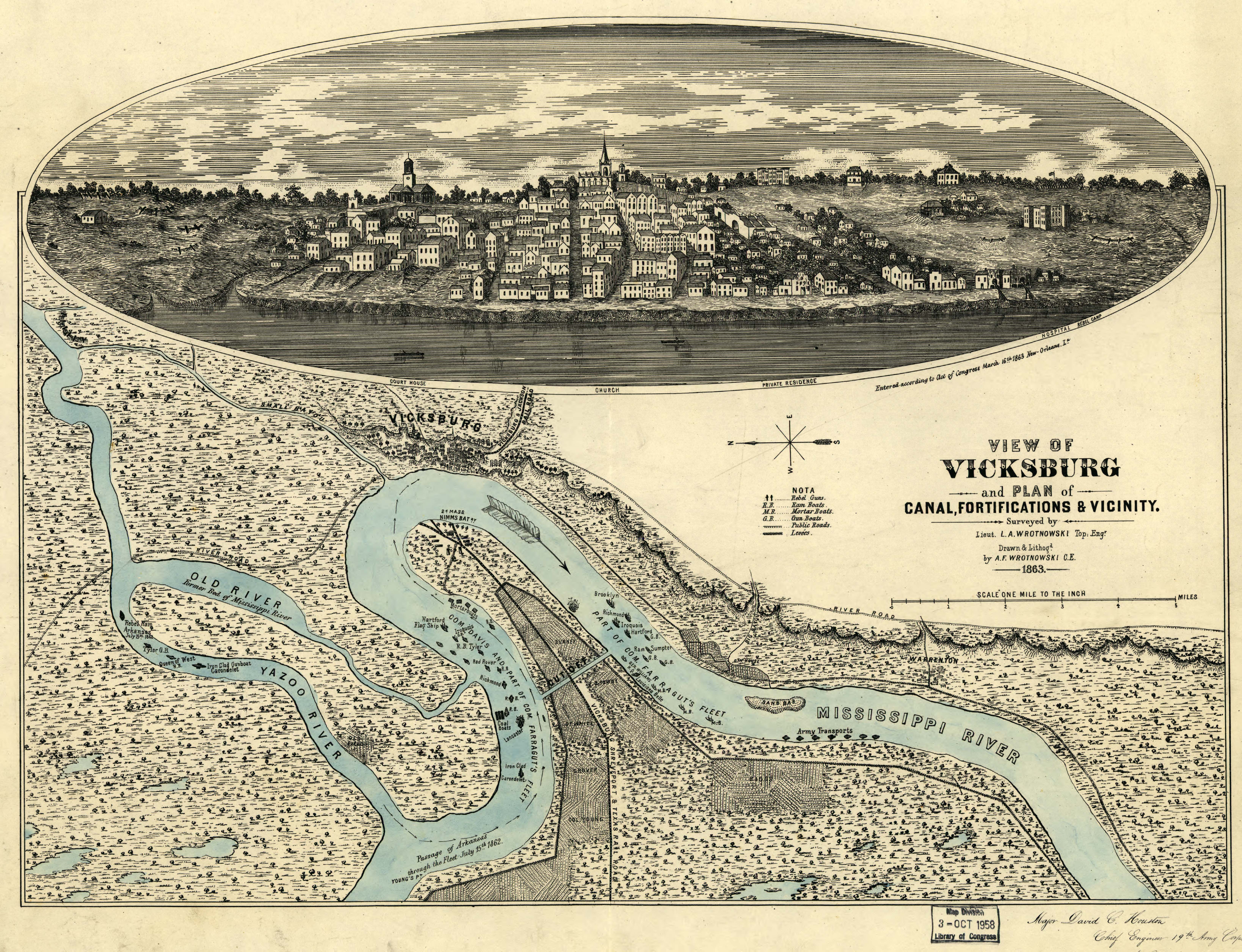
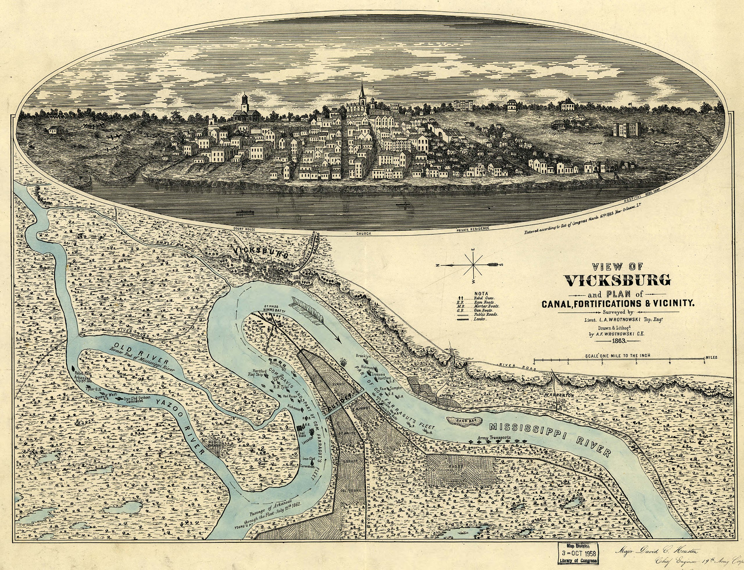
View of Vicksburg, Mississippi, 1863, during the American Civil War
Original work
View of Vicksburg and plan of the canal, fortifications & vicinity Surveyed by Lieut. L. A. Wrotnowski, Top: Engr. Drawn & lithogd. by A. F. Wrotnowski C.E.
Wrotnowski, L. A.
CREATED/PUBLISHED [S.l.], 1863.
NOTES Scale 1:63,360.
Reference: LC Civil War Maps (2nd ed.), 294
Indicates fortifications, location, type and names of boats, roads, railroads, levees, drainage, vegetation, and the names of a few residents.
Inset: [View of Vicksburg] 17 x 54 cm.
Inscribed in the lower right hand corner "Major David C. Houston, Chief Engineer, 19th Army Corps, with the compliments from the author."
Description derived from published bibliography.
SUBJECTS
Vicksburg (Miss.)--History--Civil War, 1861-1865--Maps.
United States--Mississippi--Vicksburg.
MEDIUM 1 view, col., 40 x 54 cm.
CALL NUMBER G3984.V8S5 1863 .W7 CW 294
REPOSITORY Library of Congress Geography and Map Division Washington, D.C. 20540-4650
DIGITAL ID g3984v cw0294000 http://hdl.loc.gov/loc.gmd/g3984v.cw0294000
Conditions d’utilisation
Cette image est une œuvre d'un soldat ou d'un employé de l'U.S. Army, réalisée dans le cadre de ses activités professionnelles. En tant qu'œuvre du gouvernement fédéral des États-Unis d'Amérique, cette image fait partie du domaine public.
|
 |
Historique du fichier
Cliquer sur une date et heure pour voir le fichier tel qu'il était à ce moment-là.
| Date et heure | Vignette | Dimensions | Utilisateur | Commentaire | |
|---|---|---|---|---|---|
| actuel | 3 août 2007 à 01:57 | | 6 552 × 5 024 (4,94 Mio) | Kkmurray | ==Original work== [http://lcweb2.loc.gov/cgi-bin/query/r?ammem/aaodyssey,gmd,fmuever,mmorse,upboverbib:@field(NUMBER+@band(g3984v+cw0294000))] View of Vicksburg and plan of the canal, fortifications & vicinity Surveyed by Lieut. L. A. Wrotnowski, Top: E |
Utilisation du fichier
La page suivante utilise ce fichier :
Usage global du fichier
Les autres wikis suivants utilisent ce fichier :
- Utilisation sur azb.wikipedia.org
- Utilisation sur da.wikipedia.org
- Utilisation sur en.wikipedia.org
- Utilisation sur fa.wikipedia.org
- Utilisation sur he.wikipedia.org
- Utilisation sur hu.wikipedia.org
- Utilisation sur ja.wikipedia.org
- Utilisation sur nl.wikipedia.org
- Utilisation sur pl.wikipedia.org
- Utilisation sur sh.wikipedia.org
- Utilisation sur zh.wikipedia.org