
Fichier:Viedma volcanic complex.jpg
Pas de plus haute résolution disponible.
Viedma_volcanic_complex.jpg (640 × 422 pixels, taille du fichier : 64 kio, type MIME : image/jpeg)
Ce fichier et sa description proviennent de Wikimedia Commons.
Description
| Description |
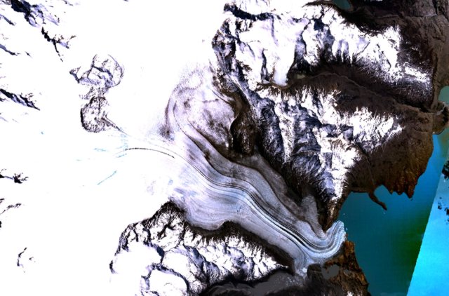
English: The figure-8-shaped area rising above the Patagonian Icefield at the upper left part of this NASA Landsat mosaic is part of the Viedma volcanic complex. An outflow glacier descends into Lake Viedma at the lower right. This mostly subglacial volcano produced an eruption in 1988 that confirmed the presence of a postulated subglacial vent in the Patagonian Icefield NW of Viedma Lake. The 1988 eruption deposited ash and pumice on the icecap and produced a mudflow that reached Viedma Lake. |
| Date | Date inconnue |
| Source | http://www.volcano.si.edu/world/volcano.cfm?vnum=1508-061&volpage=photos&photo=115011 |
| Auteur | NASA Landsat7 image (worldwind.arc.nasa.gov) |
Conditions d’utilisation
| Cette image est dans le domaine public car elle est constituée d'une capture d'écran du logiciel World Wind de la NASA qui utilise des données du domaine public, comme Blue Marble, MODIS, Landsat, SRTM, USGS ou GLOBE.
|
 |
Historique du fichier
Cliquer sur une date et heure pour voir le fichier tel qu'il était à ce moment-là.
| Date et heure | Vignette | Dimensions | Utilisateur | Commentaire | |
|---|---|---|---|---|---|
| actuel | 15 octobre 2010 à 17:37 | | 640 × 422 (64 kio) | Michael Metzger | {{Information |Description={{en|1= The figure-8-shaped area rising above the Patagonian Icefield at the upper left part of this NASA Landsat mosaic is part of the Viedma volcanic complex. An outflow glacier descends into Lake Viedma at the lower right. Th |
Utilisation du fichier
La page suivante utilise ce fichier :
Usage global du fichier
Les autres wikis suivants utilisent ce fichier :
- Utilisation sur arz.wikipedia.org
- Utilisation sur cs.wikipedia.org
- Utilisation sur de.wikipedia.org
- Utilisation sur en.wikipedia.org
- Utilisation sur es.wikipedia.org
- Utilisation sur pt.wikipedia.org
- Utilisation sur sk.wikipedia.org
- Utilisation sur uk.wikipedia.org
- Utilisation sur www.wikidata.org