
Fichier:Tropical Cyclone Monica 2006.jpg

Fichier d’origine (6 000 × 7 600 pixels, taille du fichier : 5,34 Mio, type MIME : image/jpeg)
Ce fichier et sa description proviennent de Wikimedia Commons.
Description
| Description |
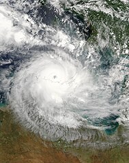
Tropical Cyclone Monica formed off the northeastern coast of Australia on April 17, 2006. This is the same general area where Cyclone Larry formed a month earlier. On April 19 and 20, Cyclone Monica crossed Cape York Peninsula with weaker winds than Larry, and its path in northern Queensland took it well away from most settled areas. However, Monica’s second act proved quite different. The cyclone gathered size and power in the Gulf of Carpentaria and rebuilt into a Category 5 storm. Monica grazed across the top of the Northern Territory, threatening communities throughout Arnhem Land, Kakadu, and the city of Darwin with heavy rains and very high winds. Many Australian news services were comparing Monica to 1974’s powerful Cyclone Tracy which flattened Darwin and was the most devastating storm to ever hit Australia. This photo-like image was acquired by the Moderate Resolution Imaging Spectroradiometer (MODIS) on the Aqua satellite on April 24, 2006, at 2:00 p.m. local time (04:30 UTC). Cyclone Monica at this time was an impressively large and powerful storm. Sustained peak winds in the storm system were roughly 285 kilometers per hour (180 miles per hour) around the time the image was captured, and gusts reached as high as 350 km/hr (220 mph). This put Monica firmly in the rare and most powerful, Category 5, rating. The eye of the storm appears like a deep whirlpool hovering just off the Australian coastline. Monica was predicted to come ashore again on the Coburg Peninsula and to strike Darwin on April 25. Ordinarily, Australians observe Anzac Day on April 25 (honoring Australians who served in the First World War), but throughout the Northern Territory, all services and events have been cancelled. The high-resolution image provided above is provided at the full MODIS spatial resolution (level of detail) of 250 meters per pixel. The MODIS Rapid Response System provides this image at additional resolutions. |
|||||
| Date | ||||||
| Source | http://earthobservatory.nasa.gov/IOTD/view.php?id=6496 | |||||
| Auteur | NASA image by Jeff Schmaltz, MODIS Rapid Response Team, Goddard Space Flight Center. | |||||
| Autorisation (Réutilisation de ce fichier) |
|

Historique du fichier
Cliquer sur une date et heure pour voir le fichier tel qu'il était à ce moment-là.
| Date et heure | Vignette | Dimensions | Utilisateur | Commentaire | |
|---|---|---|---|---|---|
| actuel | 29 août 2006 à 01:48 | | 6 000 × 7 600 (5,34 Mio) | Good kitty | == Summary == {{Information |Description=Tropical Cyclone Monica formed off the northeastern coast of Australia on April 17, 2006. This is the same general area where Cyclone Larry formed a month earlier. On April 19 and 20, Cyclone Monica crossed Cape Yo |
Utilisation du fichier
La page suivante utilise ce fichier :
Usage global du fichier
Les autres wikis suivants utilisent ce fichier :
- Utilisation sur el.wiktionary.org
- Utilisation sur en.wikipedia.org
- User talk:Icelandic Hurricane
- User:Icelandic Hurricane/2005-06 Nor'easter season
- User:Icelandic Hurricane/Nor'easter
- User:Icelandic Hurricane/Menu
- User:Icelandic Hurricane/Genealogy
- User:Icelandic Hurricane/Formulas
- User talk:Icelandic Hurricane/January Archive
- User:Icelandic Hurricane/Wubberton Jones
- User:Icelandic Hurricane/Userboxes
- User:Icelandic Hurricane/Contributions
- User talk:Icelandic Hurricane/February Archive
- User:Icelandic Hurricane/Biography
- User talk:Icelandic Hurricane/March Archive
- User talk:Icelandic Hurricane/April Archive
- User talk:Icelandic Hurricane/May Archive
- User talk:Icelandic Hurricane/June Archive
- User:Icelandic Hurricane/Music
- User talk:Icelandic Hurricane/July Archive
- User talk:Icelandic Hurricane/August Archive
- User talk:Icelandic Hurricane/September Archive
- Portal:Tropical cyclones/Did you know/Archive
- User talk:Icelandic Hurricane/October Archive
- User talk:Icelandic Hurricane/November Archive
- User talk:Icelandic Hurricane/December Archive
- User talk:Icelandic Hurricane/January 07 Archive
- User talk:Icelandic Hurricane/February 07 Archive
- User talk:Icelandic Hurricane/Recent Archive
- Utilisation sur pt.wikipedia.org
- Utilisation sur ru.wikipedia.org
- Utilisation sur uk.wikipedia.org