
Fichier:St Mark, Amcotts - geograph.org.uk - 423061.jpg
Pas de plus haute résolution disponible.
St_Mark,_Amcotts_-_geograph.org.uk_-_423061.jpg (640 × 480 pixels, taille du fichier : 70 kio, type MIME : image/jpeg)
Ce fichier et sa description proviennent de Wikimedia Commons.
Description
| Description |
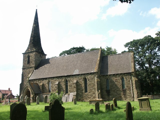
English: St Mark, Amcotts Standing near Flixborough and by the River Trent, the church of St Mark was built in the 1850s. The present building is the third to be built on the site. The foundation stone was laid on Tuesday 22nd October 1850 and was completed and dedicated to St Mark a year later, although the exact date is unknown. On 1st June 1974 the church was badly damaged with the Nypro explosion at Flixborough when the blast lifted the roof and dropped it again leaving a gap of 8 inches at the apex. The stained glass east window was completely blown in, there were cracks in the outer walls and it looked as though the church may have to be pulled down. Restoration did take place and although it also meant remaking the east window, the work was completed in two years. |
| Date | |
| Source | From geograph.org.uk |
| Auteur | Dave Hitchborne |
| Attribution (imposé par la licence) | Dave Hitchborne / St Mark, Amcotts / |
| Lieu de la prise de vue | | Voir cet endroit et d’autres images sur : OpenStreetMap |
|---|
_heading:315.00&language=fr)
| Position de l'objet | | Voir cet endroit et d’autres images sur : OpenStreetMap |
|---|
_heading:315.00&language=fr)
Conditions d’utilisation

|
Cette image provient de la collection du projet Geograph British Isles. Pour obtenir les coordonnées du photographe, veuillez consulter cette page de description de l'image sur le site du projet. Les droits d'auteurs sur cette image sont détenus par Dave Hitchborne ; l'image est placée sous une licence Creative Commons avec mention de paternité et partage à l'identique (CC-By-SA) en version 2.0.
|
Ce fichier est disponible selon les termes de la licence Creative Commons Attribution – Partage dans les Mêmes Conditions 2.0 Générique
Attribution: Dave Hitchborne
- Vous êtes libre :
- de partager – de copier, distribuer et transmettre cette œuvre
- d’adapter – de modifier cette œuvre
- Sous les conditions suivantes :
- paternité – Vous devez donner les informations appropriées concernant l'auteur, fournir un lien vers la licence et indiquer si des modifications ont été faites. Vous pouvez faire cela par tout moyen raisonnable, mais en aucune façon suggérant que l’auteur vous soutient ou approuve l’utilisation que vous en faites.
- partage à l’identique – Si vous modifiez, transformez, ou vous basez sur cette œuvre, vous devez distribuer votre contribution sous la même licence ou une licence compatible avec celle de l’original.
Historique du fichier
Cliquer sur une date et heure pour voir le fichier tel qu'il était à ce moment-là.
| Date et heure | Vignette | Dimensions | Utilisateur | Commentaire | |
|---|---|---|---|---|---|
| actuel | 4 février 2011 à 07:35 | | 640 × 480 (70 kio) | GeographBot | == {{int:filedesc}} == {{Information |description={{en|1=St Mark, Amcotts Standing near Flixborough and by the River Trent, the church of St Mark was built in the 1850s. The present building is the third to be built on the site. The foundation stone was |
Utilisation du fichier
La page suivante utilise ce fichier :
Usage global du fichier
Les autres wikis suivants utilisent ce fichier :
- Utilisation sur ceb.wikipedia.org
- Utilisation sur cy.wikipedia.org
- Utilisation sur en.wikipedia.org
- Utilisation sur lld.wikipedia.org
- Utilisation sur nl.wikipedia.org
- Utilisation sur pl.wikipedia.org
- Utilisation sur www.wikidata.org