
Fichier:St Helen, Mareham-le-Fen - geograph.org.uk - 105510.jpg
Pas de plus haute résolution disponible.
St_Helen,_Mareham-le-Fen_-_geograph.org.uk_-_105510.jpg (640 × 480 pixels, taille du fichier : 99 kio, type MIME : image/jpeg)
Ce fichier et sa description proviennent de Wikimedia Commons.
Description
| Description |
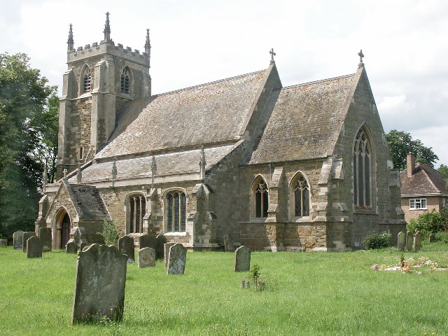
English: St Helen, Mareham-le-Fen. The earliest parts of the church date from about 1270 and they are the lower part of the tower and the tower arch. The church was largely restored in the 1870s, when the 14th-century chancel was almost entirely rebuilt. Further restoration work was done in the late 1960s and early 1970s. When the Mediaeval church of St Margaret, Old Woodhall was demolished, much of the material was brought over to build the new north vestry, kitchenette and vestibule. The font dates from the 14th-century, but the cover is modern. The registers were begun in 1558. The James Roberts gravestone, near the north door, was brought into the church to avoid further erosion. It commemorates the first voyage around the world under Captain James Cook. The famous botanist Joseph Banks from nearby Revesby was also aboard. |
| Date | |
| Source | From geograph.org.uk |
| Auteur | Dave Hitchborne |
| Attribution (imposé par la licence) | Dave Hitchborne / St Helen, Mareham-le-Fen / |
| Lieu de la prise de vue | | Voir cet endroit et d’autres images sur : OpenStreetMap |
|---|
_&language=fr)
| Position de l'objet | | Voir cet endroit et d’autres images sur : OpenStreetMap |
|---|
_&language=fr)
Conditions d’utilisation

|
Cette image provient de la collection du projet Geograph British Isles. Pour obtenir les coordonnées du photographe, veuillez consulter cette page de description de l'image sur le site du projet. Les droits d'auteurs sur cette image sont détenus par Dave Hitchborne ; l'image est placée sous une licence Creative Commons avec mention de paternité et partage à l'identique (CC-By-SA) en version 2.0.
|
Ce fichier est disponible selon les termes de la licence Creative Commons Attribution – Partage dans les Mêmes Conditions 2.0 Générique
Attribution: Dave Hitchborne
- Vous êtes libre :
- de partager – de copier, distribuer et transmettre cette œuvre
- d’adapter – de modifier cette œuvre
- Sous les conditions suivantes :
- paternité – Vous devez donner les informations appropriées concernant l'auteur, fournir un lien vers la licence et indiquer si des modifications ont été faites. Vous pouvez faire cela par tout moyen raisonnable, mais en aucune façon suggérant que l’auteur vous soutient ou approuve l’utilisation que vous en faites.
- partage à l’identique – Si vous modifiez, transformez, ou vous basez sur cette œuvre, vous devez distribuer votre contribution sous la même licence ou une licence compatible avec celle de l’original.
Historique du fichier
Cliquer sur une date et heure pour voir le fichier tel qu'il était à ce moment-là.
| Date et heure | Vignette | Dimensions | Utilisateur | Commentaire | |
|---|---|---|---|---|---|
| actuel | 31 janvier 2010 à 03:52 | | 640 × 480 (99 kio) | GeographBot | == {{int:filedesc}} == {{Information |description={{en|1=St Helen, Mareham-le-Fen. The earliest parts of the church date from about 1270 and they are the lower part of the tower and the tower arch. The church was largely restored in the 1870s, when the 14 |
Utilisation du fichier
La page suivante utilise ce fichier :
Usage global du fichier
Les autres wikis suivants utilisent ce fichier :
- Utilisation sur ceb.wikipedia.org
- Utilisation sur cy.wikipedia.org
- Utilisation sur de.wikipedia.org
- Utilisation sur en.wikipedia.org
- Utilisation sur es.wikipedia.org
- Utilisation sur fa.wikipedia.org
- Utilisation sur it.wikipedia.org
- Utilisation sur lld.wikipedia.org
- Utilisation sur pl.wikipedia.org
- Utilisation sur www.wikidata.org