
Fichier:ShigaMapCurrent.png

Taille de cet aperçu : 734 × 599 pixels. Autres résolutions : 294 × 240 pixels | 588 × 480 pixels | 981 × 801 pixels.
Fichier d’origine (981 × 801 pixels, taille du fichier : 42 kio, type MIME : image/png)
Ce fichier et sa description proviennent de Wikimedia Commons.
Description
| Description |
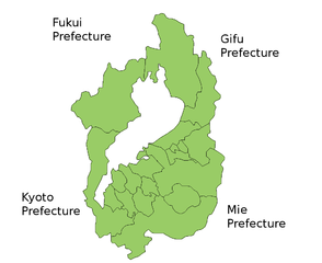
Map of Shiga Prefecture, Japan. Thanks to Aoki Shigenobu and [1]. Colors from Image:TokyoMapCurrent.png by User:Fg2. |
| Date | 19 juillet 2006 (date de téléversement originale) |
| Source | La source n’a pas pu être reconnue automatiquement. « Travail personnel » supposé (étant donné la revendication de droit d’auteur). |
| Auteur | L’auteur n’a pas pu être identifié automatiquement. Il est supposé qu'il s'agit de : Akanemoto~commonswiki (étant donné la revendication de droit d’auteur). |
Conditions d’utilisation
| Moi, propriétaire des droits d’auteur sur cette œuvre, la place dans le domaine public. Ceci s'applique dans le monde entier. Dans certains pays, ceci peut ne pas être possible ; dans ce cas : J’accorde à toute personne le droit d’utiliser cette œuvre dans n’importe quel but, sans aucune condition, sauf celles requises par la loi. |
Historique du fichier
Cliquer sur une date et heure pour voir le fichier tel qu'il était à ce moment-là.
| Date et heure | Vignette | Dimensions | Utilisateur | Commentaire | |
|---|---|---|---|---|---|
| actuel | 10 septembre 2011 à 05:35 | | 981 × 801 (42 kio) | Kyoww | The mergers of Nagahama and Omihachiman |
| 19 juillet 2006 à 19:59 |  | 981 × 801 (30 kio) | Akanemoto~commonswiki | Map of Shiga Prefecture, Japan. Thanks to Aoki Shigenobu and [http://aoki2.si.gunma-u.ac.jp/map/map.html]. Colors from Image:TokyoMapCurrent.png by User:Fg2. Category:Maps of Shiga prefecture Category:Maps in English |
Utilisation du fichier
Aucune page n’utilise ce fichier.
Usage global du fichier
Les autres wikis suivants utilisent ce fichier :
- Utilisation sur az.wikipedia.org
- Utilisation sur ckb.wikipedia.org
- Utilisation sur cs.wikipedia.org
- Utilisation sur id.wikipedia.org
- Utilisation sur jv.wikipedia.org
- Utilisation sur lt.wikipedia.org
- Utilisation sur mn.wikipedia.org
- Utilisation sur no.wikipedia.org
- Utilisation sur ru.wikipedia.org