
Fichier:San Francisquito Reservoir on topo v2.jpg
Taille de cet aperçu : 783 × 600 pixels. Autres résolutions : 313 × 240 pixels | 627 × 480 pixels | 1 003 × 768 pixels | 1 280 × 981 pixels | 2 560 × 1 961 pixels | 3 065 × 2 348 pixels.
Fichier d’origine (3 065 × 2 348 pixels, taille du fichier : 4,46 Mio, type MIME : image/jpeg)
Ce fichier et sa description proviennent de Wikimedia Commons.
Description
| Description |
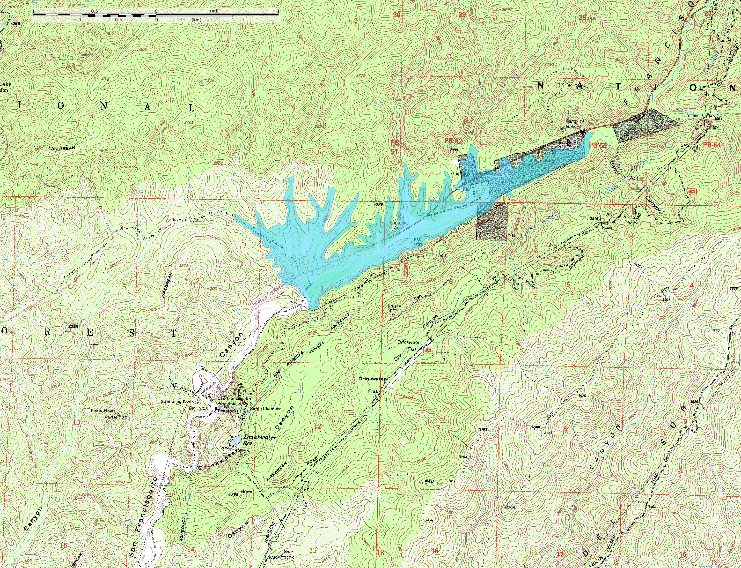
English: This map shows the approximate extent of the former San Francisquito Reservoir. The reservoir was impounded by the St. Francis Dam which failed in 1928. According to this depiction the reservoir was approximately 2.8 miles (4.5 km) long. In addition to the reservoir this map also shows the location of part of the Los Angeles Aqueduct from which it was filled; it was built as a storage stucture for the aqueduct. Also visible on the map at full size is the location of Powerhouse #2 which figures in the story of the flood created by the failure of the dam. The dark blocks indicate private inholdings in the national forest.
The reservoir extent was determined by tracing at or just below the 1840-foot elevation contour; the pool elevation was about 1835 feet when full and when the dam collapsed. The topo map includes sections of the Warm Springs Mountain 7.5" quadrangle (o34118e5) and the Green Valley quadrangle (o34118e4) from the USGS obtained as DRG files. Note: The location and orientation of the dam (at the southwest extent of the reservoir) is approximate. Additionally, the elevation data in this map is from after the breach of the dam, which caused significant erosion of the hillside at the southeast abuttment; the dam was probably a little smaller than this reconstruction depicts. |
| Date | |
| Source | Travail personnel |
| Auteur | Kbh3rd |
| Autres versions |
 |
| Lieu de la prise de vue | | Voir cet endroit et d’autres images sur : OpenStreetMap |
|---|
Conditions d’utilisation
Moi, en tant que détenteur des droits d’auteur sur cette œuvre, je la publie sous les licences suivantes :
Ce fichier est disponible selon les termes de la licence Creative Commons Attribution – Partage dans les Mêmes Conditions 3.0 (non transposée).
- Vous êtes libre :
- de partager – de copier, distribuer et transmettre cette œuvre
- d’adapter – de modifier cette œuvre
- Sous les conditions suivantes :
- paternité – Vous devez donner les informations appropriées concernant l'auteur, fournir un lien vers la licence et indiquer si des modifications ont été faites. Vous pouvez faire cela par tout moyen raisonnable, mais en aucune façon suggérant que l’auteur vous soutient ou approuve l’utilisation que vous en faites.
- partage à l’identique – Si vous modifiez, transformez, ou vous basez sur cette œuvre, vous devez distribuer votre contribution sous la même licence ou une licence compatible avec celle de l’original.

|
Vous avez la permission de copier, distribuer et modifier ce document selon les termes de la GNU Free Documentation License version 1.2 ou toute version ultérieure publiée par la Free Software Foundation, sans sections inaltérables, sans texte de première page de couverture et sans texte de dernière page de couverture. Un exemplaire de la licence est inclus dans la section intitulée GNU Free Documentation License. |
Vous pouvez choisir l’une de ces licences.
Historique du fichier
Cliquer sur une date et heure pour voir le fichier tel qu'il était à ce moment-là.
| Date et heure | Vignette | Dimensions | Utilisateur | Commentaire | |
|---|---|---|---|---|---|
| actuel | 8 juin 2009 à 06:12 | | 3 065 × 2 348 (4,46 Mio) | Kbh3rd | {{Information |Description={{en|1=This map shows the approximate extent of the former San Francisquito Reservoir. The reservoir was impounded by the St. Francis Dam which failed in 1928. According to this depiction the reservoir |
Utilisation du fichier
La page suivante utilise ce fichier :
Usage global du fichier
Les autres wikis suivants utilisent ce fichier :
- Utilisation sur de.wikipedia.org
- Utilisation sur en.wikipedia.org
- Utilisation sur ja.wikipedia.org