
Fichier:SaltGlaciers ZagrosMtns 20010810.jpg
Taille de cet aperçu : 800 × 509 pixels. Autres résolutions : 320 × 204 pixels | 640 × 407 pixels | 1 149 × 731 pixels.
Fichier d’origine (1 149 × 731 pixels, taille du fichier : 231 kio, type MIME : image/jpeg)
Ce fichier et sa description proviennent de Wikimedia Commons.
Description
| Position de l'objet | | Voir cet endroit et d’autres images sur : OpenStreetMap |
|---|
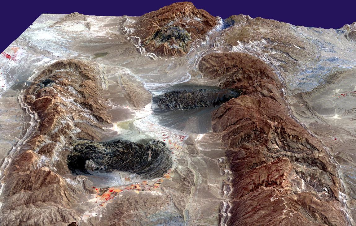
| Description | Satellite imagery of salt domes and salt glaciers, visible as darkish irregular patches, Zagros Mountains, southern Iran, near Karmowstaj. Gravity has caused the salt to flow like glaciers into adjacent valleys. The resulting tongue-shaped bodies are more than 5 kilometers long, with repeating bow-shaped ridges separated by crevasse-like gullies and with steep sides and fronts. The darker tones are due to clays brought up with the salt, as well as the probable accumulation of airborne dust. This Aster perspective view was created by draping a band 3-2-1 (RGB) image over an ASTER-derived Digital Elevation Model (2x vertical exaggeration). |
| Date | |
| Source | http://earthobservatory.nasa.gov/IOTD/view.php?id=4168 |
| Auteur | NASA/GSFC/MITI/ERSDAC/JAROS, and U.S./Japan ASTER Science Team |
| Autorisation (Réutilisation de ce fichier) |
US government, public domain |
Conditions d’utilisation
| Ce fichier provient de la NASA. Sauf exception, les documents créés par la NASA ne sont pas soumis à copyright. Pour plus d'informations, voir la politique de copyright de la NASA. | ||
 |
Attention :
|
Historique du fichier
Cliquer sur une date et heure pour voir le fichier tel qu'il était à ce moment-là.
| Date et heure | Vignette | Dimensions | Utilisateur | Commentaire | |
|---|---|---|---|---|---|
| actuel | 27 avril 2006 à 18:49 | | 1 149 × 731 (231 kio) | Holly Cheng | {{Information | Description=Satellite imagery of w:salt domes and w:salt glaciers in the w:Zagros Mountains of southern Iran. This w:ASTER perspective view was created by draping a band 3-2-1 (RGB) image over an ASTER-derived Digital Eleva |
Utilisation du fichier
La page suivante utilise ce fichier :
Usage global du fichier
Les autres wikis suivants utilisent ce fichier :
- Utilisation sur ar.wikipedia.org
- Utilisation sur ast.wikipedia.org
- Utilisation sur bs.wikipedia.org
- Utilisation sur ca.wikipedia.org
- Utilisation sur cs.wikipedia.org
- Utilisation sur de.wikipedia.org
- Utilisation sur en.wikipedia.org
- Utilisation sur es.wikipedia.org
- Utilisation sur fa.wikipedia.org
- Utilisation sur hr.wikipedia.org
- Utilisation sur it.wikipedia.org
- Utilisation sur ja.wikipedia.org
- Utilisation sur ru.wikipedia.org
- Utilisation sur sh.wikipedia.org
- Utilisation sur sr.wikipedia.org
- Utilisation sur uk.wikipedia.org