
Fichier:Route of the Expedition from York Factory to Cumberland House and the Summer & Winter Tracks from thence to Isle A La Crosse in 1819 & 1820 (1823).jpg
Fichier d’origine (6 514 × 2 956 pixels, taille du fichier : 4,78 Mio, type MIME : image/jpeg)
Ce fichier et sa description proviennent de Wikimedia Commons.
.jpg?uselang=fr)
Description
| Description |
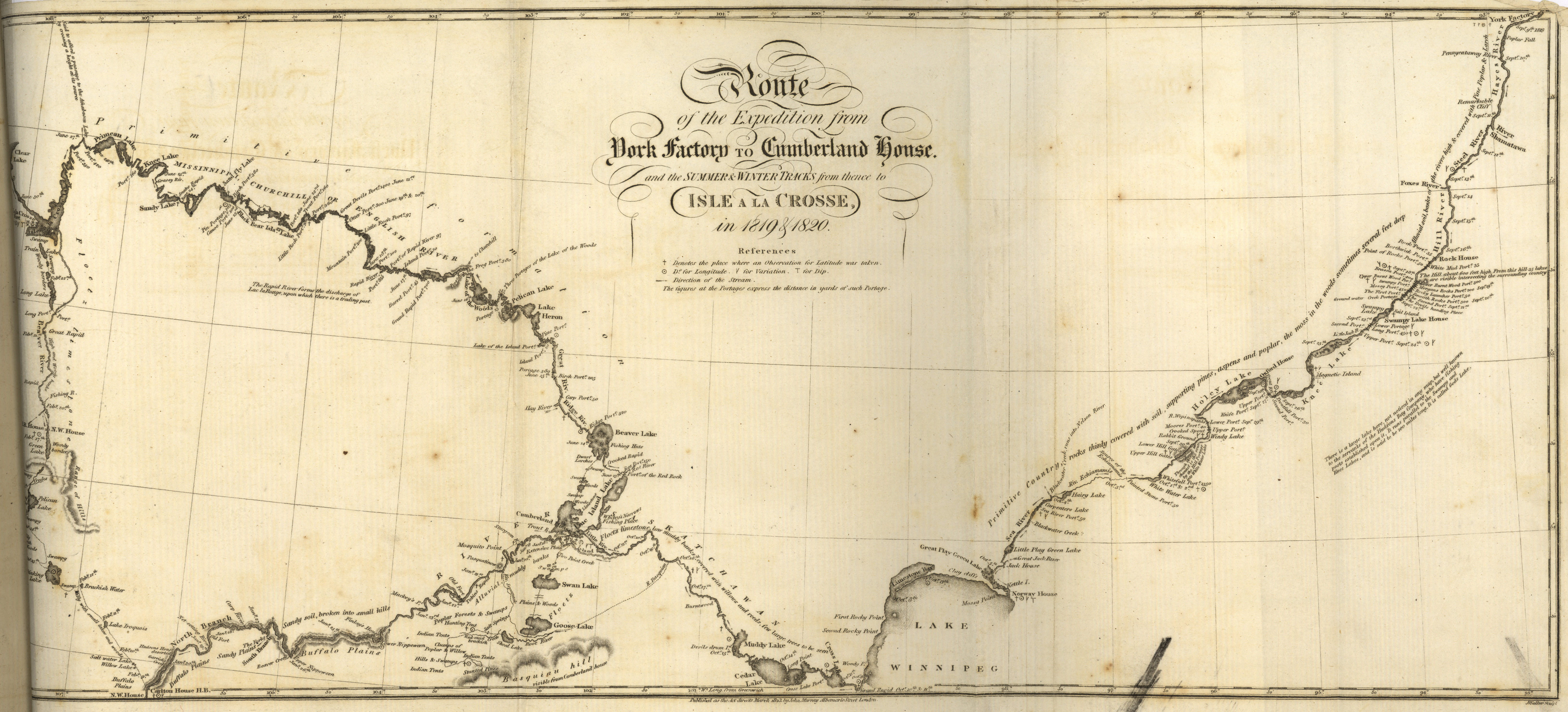
Franklin, John. Route of the Expedition from York Factory to Cumberland House and the Summer & Winter Tracks from thence to Isle a la Crosse in 1819 & 1920 [map]. Scale not given. In: John Franklin. Narrative of a Journey to the Shores of the Polar Sea, in the Years 1819, 20, 21, and 22. London: John Murray, 1823. Shows the places where an Observation for Latitude was taken. Figures at the portages express the distance in yards. Captain John Franklin's two land expeditions to the Arctic traveled through the area which today is Manitoba, and added substantially to the scientific knowledge of both the northern and southern parts of the province. On the this map showing the Franklin expeditions’ journey in 1819 from York Factory to the Saskatchewan river there are comments on vegetation, depth of soil, and the fact that the bedrock is of a Primitive age. This is probably the first recording of the relative ages of rocks on any published map of the Manitoba area. Progress of the expedition can be easily followed since all the camping places are marked. On these maps we see the first results of the application of scientific knowledge by experienced scientific observers to the recording of data on the West. The base maps were from Arrowsmith, but in turn Arrowsmith and other cartographers obtained important information from the Franklin's Expeditions. (Warkentin and Ruggles. Historical Atlas of Manitoba. map 81, p. 206) Related Map: Route of the Expedition from Isle a la Crosse to Fort Providence in 1819 & 20 (1823) www.flickr.com/photos/manitobamaps/3751971809/ Image Courtesy of University of Manitoba : Archives & Special Collections |
| Date | |
| Source | Route of the Expedition from York Factory to Cumberland House and the Summer & Winter Tracks from thence to Isle A La Crosse in 1819 & 1820 (1823) |
| Auteur | John Franklin via Manitoba Historical Maps |
Conditions d’utilisation
- Vous êtes libre :
- de partager – de copier, distribuer et transmettre cette œuvre
- d’adapter – de modifier cette œuvre
- Sous les conditions suivantes :
- paternité – Vous devez donner les informations appropriées concernant l'auteur, fournir un lien vers la licence et indiquer si des modifications ont été faites. Vous pouvez faire cela par tout moyen raisonnable, mais en aucune façon suggérant que l’auteur vous soutient ou approuve l’utilisation que vous en faites.
Historique du fichier
Cliquer sur une date et heure pour voir le fichier tel qu'il était à ce moment-là.
| Date et heure | Vignette | Dimensions | Utilisateur | Commentaire | |
|---|---|---|---|---|---|
| actuel | 11 mars 2012 à 22:35 | | 6 514 × 2 956 (4,78 Mio) | Jeangagnon | taille originale |
| 6 mars 2011 à 14:48 |  | 500 × 227 (85 kio) | Geo Swan | {{Information |Description=Franklin, John. Route of the Expedition from York Factory to Cumberland House and the Summer & Winter Tracks from thence to Isle a la Crosse in 1819 & 1920 [map]. Scale not given. In: John Franklin. Narrative of a Journey to the |
Utilisation du fichier
Les 2 pages suivantes utilisent ce fichier :
.jpg)