
Fichier:Piracy Decline LRIT.png
Taille de cet aperçu : 800 × 319 pixels. Autres résolutions : 320 × 127 pixels | 640 × 255 pixels | 1 502 × 598 pixels.
Fichier d’origine (1 502 × 598 pixels, taille du fichier : 1,17 Mio, type MIME : image/png)
Ce fichier et sa description proviennent de Wikimedia Commons.
Description
| Description |
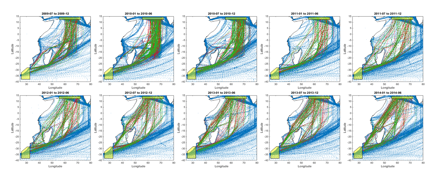
English: Time series of maritime traffic crossing the Indian Ocean showing the effect of piracy and its progressive decline in re-routing ships. Each sub-plot shows 6-month colour-coded trips, red southbound and green northbound, using Long Range Identification and Tracking (LRIT) historical data. Operational authorities requested an increase of LRIT reporting frequency from ships in 2009 and 2010 in order to better track them remotely in the High Risk Area. The increase of tracking points can be erroneously perceived as an apparently higher volume of traffic with respect to other periods.
Published in Vespe M., Greidanus H., Alvarez M., 'The declining impact of piracy on maritime transport in the Indian Ocean: Statistical analysis of 5-year vessel tracking data'. Marine Policy. 59: 9–15. DOI:10.1016/j.marpol.2015.04.018. [1] |
| Date | |
| Source | Travail personnel |
| Auteur | Lampred8 |
Conditions d’utilisation
Moi, en tant que détenteur des droits d’auteur sur cette œuvre, je la publie sous la licence suivante :
Ce fichier est sous la licence Creative Commons Attribution – Partage dans les Mêmes Conditions 4.0 International.
- Vous êtes libre :
- de partager – de copier, distribuer et transmettre cette œuvre
- d’adapter – de modifier cette œuvre
- Sous les conditions suivantes :
- paternité – Vous devez donner les informations appropriées concernant l'auteur, fournir un lien vers la licence et indiquer si des modifications ont été faites. Vous pouvez faire cela par tout moyen raisonnable, mais en aucune façon suggérant que l’auteur vous soutient ou approuve l’utilisation que vous en faites.
- partage à l’identique – Si vous modifiez, transformez, ou vous basez sur cette œuvre, vous devez distribuer votre contribution sous la même licence ou une licence compatible avec celle de l’original.
- ↑ (1 September 2015). "The declining impact of piracy on maritime transport in the Indian Ocean: Statistical analysis of 5-year vessel tracking data". Marine Policy 59: 9–15. DOI:10.1016/j.marpol.2015.04.018.
Historique du fichier
Cliquer sur une date et heure pour voir le fichier tel qu'il était à ce moment-là.
| Date et heure | Vignette | Dimensions | Utilisateur | Commentaire | |
|---|---|---|---|---|---|
| actuel | 31 juillet 2016 à 18:35 | 1 502 × 598 (1,17 Mio) | Lampred8 | Cross-wiki upload from en.wikipedia.org |
Utilisation du fichier
Aucune page n’utilise ce fichier.
Usage global du fichier
Les autres wikis suivants utilisent ce fichier :
- Utilisation sur en.wikipedia.org