
Fichier:Peten Map v3 May archaeological sites.gif

Taille de cet aperçu : 684 × 599 pixels. Autres résolutions : 274 × 240 pixels | 548 × 480 pixels | 979 × 858 pixels.
Fichier d’origine (979 × 858 pixels, taille du fichier : 47 kio, type MIME : image/gif)
Ce fichier et sa description proviennent de Wikimedia Commons.
Description
| Description |
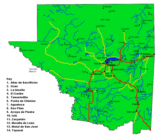
English: Map of the Maya archaeological sites in El Petén Department.
Español: Mapa del departamento guatemalteco de Petén, con los más importantes sitios arqueológicos Mayas. |
| Date | |
| Source | Travail personnel |
| Auteur | Simon Burchell |
Conditions d’utilisation
Moi, en tant que détenteur des droits d’auteur sur cette œuvre, je la publie sous la licence suivante :
Ce fichier est disponible selon les termes de la licence Creative Commons Attribution – Partage dans les Mêmes Conditions 3.0 (non transposée).
- Vous êtes libre :
- de partager – de copier, distribuer et transmettre cette œuvre
- d’adapter – de modifier cette œuvre
- Sous les conditions suivantes :
- paternité – Vous devez donner les informations appropriées concernant l'auteur, fournir un lien vers la licence et indiquer si des modifications ont été faites. Vous pouvez faire cela par tout moyen raisonnable, mais en aucune façon suggérant que l’auteur vous soutient ou approuve l’utilisation que vous en faites.
- partage à l’identique – Si vous modifiez, transformez, ou vous basez sur cette œuvre, vous devez distribuer votre contribution sous la même licence ou une licence compatible avec celle de l’original.
Historique du fichier
Cliquer sur une date et heure pour voir le fichier tel qu'il était à ce moment-là.
| Date et heure | Vignette | Dimensions | Utilisateur | Commentaire | |
|---|---|---|---|---|---|
| actuel | 19 novembre 2010 à 14:38 | | 979 × 858 (47 kio) | Simon Burchell | Remove stray ruins symbols that crept in during last edit. |
| 19 novembre 2010 à 14:31 |  | 979 × 858 (47 kio) | Simon Burchell | Added some more archaeological sites. | |
| 19 novembre 2010 à 13:14 |  | 979 × 858 (46 kio) | Simon Burchell | Correct location of La Blanca, added location of Ucanal and moved Holtun text. | |
| 18 novembre 2010 à 13:19 |  | 979 × 858 (46 kio) | Simon Burchell | {{Information |Description={{en|1=Map of the Peten department of Guatemala with important Maya archaeological sites marked.}} {{es|1=Mapa del departamento guatemalteco de Petén, con los más importantes sitios arqueológicos mayas.}} |Source={{own}} |Aut |
Utilisation du fichier
La page suivante utilise ce fichier :
Usage global du fichier
Les autres wikis suivants utilisent ce fichier :
- Utilisation sur bn.wikipedia.org
- Utilisation sur ca.wikipedia.org
- Utilisation sur de.wikivoyage.org
- Utilisation sur el.wikipedia.org
- Utilisation sur en.wikipedia.org
- Utilisation sur eo.wikipedia.org
- Utilisation sur es.wikipedia.org
- Utilisation sur hy.wikipedia.org
- Utilisation sur it.wikipedia.org
- Utilisation sur ja.wikipedia.org
- Utilisation sur zh.wikipedia.org