
Fichier:Oversea territories.PNG

Taille de cet aperçu : 800 × 369 pixels. Autres résolutions : 320 × 148 pixels | 640 × 295 pixels | 1 362 × 628 pixels.
Fichier d’origine (1 362 × 628 pixels, taille du fichier : 93 kio, type MIME : image/png)
Ce fichier et sa description proviennent de Wikimedia Commons.

|
Ce fichier a été remplacé par File:EU OCT and OMR map.png. Il est recommandé d’utiliser l’autre fichier. La suppression des fichiers remplacés requiert un accord.
|
Description
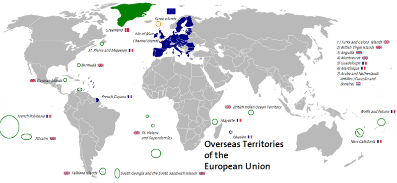
| Description | This map shows associated and not associated overseas territories of the member states (France, United Kingdom, Denmark, Netherlands) of the European Union. The map is own work. |
| Date | 20 juillet 2006 (date de téléversement originale) |
| Source | La source n’a pas pu être reconnue automatiquement. « Travail personnel » supposé (étant donné la revendication de droit d’auteur). |
| Auteur | L’auteur n’a pas pu être identifié automatiquement. Il est supposé qu'il s'agit de : CedricBLN (étant donné la revendication de droit d’auteur). |
Conditions d’utilisation
Moi, en tant que détenteur des droits d’auteur sur cette œuvre, je la publie sous la licence suivante :
Ce fichier est disponible selon les termes de la licence Creative Commons Attribution – Partage dans les Mêmes Conditions 2.5 Générique
- Vous êtes libre :
- de partager – de copier, distribuer et transmettre cette œuvre
- d’adapter – de modifier cette œuvre
- Sous les conditions suivantes :
- paternité – Vous devez donner les informations appropriées concernant l'auteur, fournir un lien vers la licence et indiquer si des modifications ont été faites. Vous pouvez faire cela par tout moyen raisonnable, mais en aucune façon suggérant que l’auteur vous soutient ou approuve l’utilisation que vous en faites.
- partage à l’identique – Si vous modifiez, transformez, ou vous basez sur cette œuvre, vous devez distribuer votre contribution sous la même licence ou une licence compatible avec celle de l’original.
Historique du fichier
Cliquer sur une date et heure pour voir le fichier tel qu'il était à ce moment-là.
| Date et heure | Vignette | Dimensions | Utilisateur | Commentaire | |
|---|---|---|---|---|---|
| actuel | 2 octobre 2014 à 04:47 | | 1 362 × 628 (93 kio) | Leftcry | South Sudan;Minor accuracy |
| 30 juin 2013 à 07:00 |  | 1 362 × 628 (93 kio) | Spesh531 | croatia | |
| 2 janvier 2007 à 15:51 |  | 1 362 × 628 (82 kio) | CedricBLN | {{Information |Description= This map shows associated and not associated overseas territories of the member states (France, United Kingdom, Denmark, Netherlands) of the European Union. The map is own work. |Source= |Date= 1/1/2007 |Author= Ben Titze |Perm | |
| 20 juillet 2006 à 02:11 |  | 1 362 × 628 (82 kio) | CedricBLN | {{Information |Description= This map shows associated and not associated overseas territories of the member states (France, United Kingdom, Denmark, Netherlands) of the European Union. The map is own work. |Source= Own work, based upon data from the Fi | |
| 20 juillet 2006 à 02:08 |  | 1 362 × 628 (82 kio) | CedricBLN | This map shows associated and not associated overseas territories of the member states (France, United Kingdom, Denmark, Netherlands) of the European Union. The map is own work. |
Utilisation du fichier
Aucune page n’utilise ce fichier.
Usage global du fichier
Les autres wikis suivants utilisent ce fichier :
- Utilisation sur de.wikipedia.org
- Utilisation sur en.wikipedia.org