
Fichier:Orleans County (New York) - Towns and Villages.svg

Taille de cet aperçu PNG pour ce fichier SVG : 800 × 587 pixels. Autres résolutions : 320 × 235 pixels | 640 × 469 pixels | 1 024 × 751 pixels | 1 280 × 939 pixels | 2 560 × 1 877 pixels | 1 500 × 1 100 pixels.
Fichier d’origine (Fichier SVG, nominalement de 1 500 × 1 100 pixels, taille : 28 kio)
Ce fichier et sa description proviennent de Wikimedia Commons.
_-_Towns_and_Villages.svg?uselang=fr)
Description
| Description |
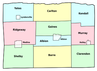
English: Map of Orleans County, New York, showing its constituent towns and villages. Labels in English. |
| Date | |
| Source | Own work by uploader, based on public domain USGS topographic maps |
| Auteur | LtPowers |
| Autres versions | Image:Orleans County (New York) outline.jpg |
_outline.jpg&action=edit&redlink=1)
Cette image vectorielle non W3C-spécifiée a été créée avec Inkscape .
Conditions d’utilisation
Moi, en tant que détenteur des droits d’auteur sur cette œuvre, je la publie sous la licence suivante :
Ce fichier est disponible selon les termes de la licence Creative Commons Attribution – Partage dans les Mêmes Conditions 3.0 (non transposée).
- Vous êtes libre :
- de partager – de copier, distribuer et transmettre cette œuvre
- d’adapter – de modifier cette œuvre
- Sous les conditions suivantes :
- paternité – Vous devez donner les informations appropriées concernant l'auteur, fournir un lien vers la licence et indiquer si des modifications ont été faites. Vous pouvez faire cela par tout moyen raisonnable, mais en aucune façon suggérant que l’auteur vous soutient ou approuve l’utilisation que vous en faites.
- partage à l’identique – Si vous modifiez, transformez, ou vous basez sur cette œuvre, vous devez distribuer votre contribution sous la même licence ou une licence compatible avec celle de l’original.
Historique du fichier
Cliquer sur une date et heure pour voir le fichier tel qu'il était à ce moment-là.
| Date et heure | Vignette | Dimensions | Utilisateur | Commentaire | |
|---|---|---|---|---|---|
| actuel | 11 novembre 2008 à 23:46 | | 1 500 × 1 100 (28 kio) | LtPowers | change village labels to condensed and increase point size accordingly |
| 11 novembre 2008 à 23:38 |  | 1 500 × 1 100 (28 kio) | LtPowers | reduce lower margin | |
| 11 novembre 2008 à 23:27 |  | 1 500 × 1 500 (28 kio) | LtPowers | {{Information |Description={{en|1=Map of Orleans County, New York, showing its constituent towns and villages. Labels in English.}} |Source=Own work by uploader, based on public domain USGS topographic maps |Author=[[User:L |
Utilisation du fichier
La page suivante utilise ce fichier :
Usage global du fichier
Les autres wikis suivants utilisent ce fichier :
- Utilisation sur en.wikipedia.org
- Orleans County, New York
- Oak Orchard State Marine Park
- Lakeside Beach State Park
- Barre Center, New York
- Childs, New York
- Template:OrleansCountyNY-geo-stub
- Millers, New York
- Oak Orchard, New York
- Millville, New York
- Hulberton, New York
- Kent, Orleans County, New York
- Knowlesville, New York
- Waterport, New York
- Sawyer, Orleans County, New York
- East Gaines, New York
- Utilisation sur es.wikipedia.org
- Utilisation sur ja.wikipedia.org
- Utilisation sur nl.wikipedia.org
- Utilisation sur www.wikidata.org
_-_Towns_and_Villages.svg)