
Fichier:Orchard Park Municipal Center, Orchard Park, New York - 20201206.jpg

Taille de cet aperçu : 800 × 480 pixels. Autres résolutions : 320 × 192 pixels | 1 024 × 614 pixels | 1 280 × 768 pixels | 2 560 × 1 536 pixels | 4 032 × 2 419 pixels.
Fichier d’origine (4 032 × 2 419 pixels, taille du fichier : 3,06 Mio, type MIME : image/jpeg)
Ce fichier et sa description proviennent de Wikimedia Commons.
Description
| Description |
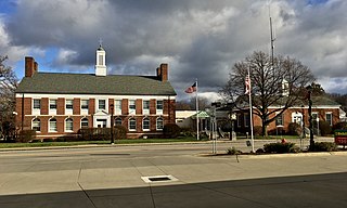
English: The Orchard Park Municipal Center, 4295 South Buffalo Street, Orchard Park, New York, December 2020. Respectively, the two wings of the building house the town and village offices (left) and the police department (right) and were built in 1949 as separate structures; an expansion in 1990 (center) served to connect the two and also added additional space in the rear. The original portions of the building, designed by the firm of Hudson & Hudson, exemplify the Colonial Revival style of architecture, which at that time retained a great deal of popularity in designs for government, school, and other institutional buildings, even as it had already passed out of favor in the arena of residential architecture. Both of the designs include classic Colonial hallmarks such as symmetrical façades and side-gabled roofs each with a central copper-topped cupola, but they differ from each other in the fine details. The more elaborate town hall portion sports a pedimented entrance, ornamental twin chimneys on the side elevations adjacent to the peak of the roof, and a contrast between the windows on the ground floor (round-arched and topped consecutively with fanlights and decorative keystones) and the second floor (rectangular and topped with stone lintels), with stone belt courses delineating the boundaries between floors. Meanwhile, the single-story and more modestly designed police station has a segmental-arched entrance with a golden eagle adorning the tympanum. |
| Date | Prise le 6 décembre 2020, 13:59:50 |
| Source | Travail personnel |
| Auteur | Andre Carrotflower |
| Lieu de la prise de vue | | Voir cet endroit et d’autres images sur : OpenStreetMap |
|---|
Conditions d’utilisation
Moi, en tant que détenteur des droits d’auteur sur cette œuvre, je la publie sous la licence suivante :
Ce fichier est sous la licence Creative Commons Attribution – Partage dans les Mêmes Conditions 4.0 International.
- Vous êtes libre :
- de partager – de copier, distribuer et transmettre cette œuvre
- d’adapter – de modifier cette œuvre
- Sous les conditions suivantes :
- paternité – Vous devez donner les informations appropriées concernant l'auteur, fournir un lien vers la licence et indiquer si des modifications ont été faites. Vous pouvez faire cela par tout moyen raisonnable, mais en aucune façon suggérant que l’auteur vous soutient ou approuve l’utilisation que vous en faites.
- partage à l’identique – Si vous modifiez, transformez, ou vous basez sur cette œuvre, vous devez distribuer votre contribution sous la même licence ou une licence compatible avec celle de l’original.
Historique du fichier
Cliquer sur une date et heure pour voir le fichier tel qu'il était à ce moment-là.
| Date et heure | Vignette | Dimensions | Utilisateur | Commentaire | |
|---|---|---|---|---|---|
| actuel | 14 janvier 2021 à 02:43 | | 4 032 × 2 419 (3,06 Mio) | Andre Carrotflower | Uploaded own work with UploadWizard |
Utilisation du fichier
La page suivante utilise ce fichier :
Usage global du fichier
Les autres wikis suivants utilisent ce fichier :
- Utilisation sur ar.wikipedia.org
- Utilisation sur ca.wikipedia.org
- Utilisation sur es.wikipedia.org
- Utilisation sur pl.wikipedia.org
- Utilisation sur uk.wikipedia.org
- Utilisation sur www.wikidata.org