Aller au contenu

Fichier:Omani Empire 2.png

Le contenu de la page n’est pas pris en charge dans d’autres langues.
Une page de Wikipédia, l'encyclopédie libre.

Fichier d’origine(4 645 × 4 399 pixels, taille du fichier : 2,21 Mio, type MIME : image/png)

Ce fichier et sa description proviennent de Wikimedia Commons.

Description

Description
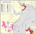
English: A highly detailed english chronological map of the yarubid imamate and albusaid empire and sultanates in Oman and Zanzibar
Date
Source

Own work based on:

- https://www.worldstatesmen.org/Mozambique_native.html

- (Newitt, Malyn. A History of Mozambique. Indiana University Press, Bloomington, IN, 1995.)

- https://www.worldstatesmen.org/Tanzania_native.html

- https://www.worldstatesmen.org/Kenya_native.html

- https://understandingthehorn.berkeley.edu/horn-africa-1730-ce (uses - https://operationoverload.wordpress.com/category/mogadishu/)

- https://books.google.com.eg/books?id=WixiTjxYdkYC&pg=PA521&redir_esc=y#v=onepage&q&f=false

- https://en.wikipedia.org/wiki/Sultanate_of_Zanzibar

- (https://www.worldcat.org/title/zanzibar-its-history-and-its-people/oclc/186237036)

- (https://archive.org/details/africanaencyclop00appi)

- (http://www.heliograph.com/trmgs/trmgs2/bea.shtml)

- (http://hansard.millbanksystems.com/commons/1895/jun/13/british-east-africa#S4V0034P0_18950613_HOC_216)

- (https://books.google.com.eg/books?id=2WOuAAAAIAAJ&redir_esc=y)

- https://en.wikipedia.org/wiki/East_Africa_Protectorate

- (https://www.fotw.info/flags/eaf-brit.html#%3Cww1)

- https://en.wikipedia.org/wiki/Rumaliza - https://commons.wikimedia.org/wiki/File:Stanley_Founding_of_Congo_Free_State_365_Political_Divisions_of_the_Congo_Basin.jpg

- hisatlas

- other sources, books, jstor papers

- Tubinger's Atlas

- Journal of African Studies

Sources that confirm the map:

- The Cambridge History of Africa Vol. 5, p. 275

- Oman in History. pp. 445-463

- Muqdisho in the Nineteenth Century: A Regional Perspective. The Journal of African History, Vol. 24, No. 4 (1983), pp. 441-459

- The Swahili Coast: Politics, Diplomacy and Trade on the East African Littoral, 1798-1856

- Somalia: Nation in Search of a State

- Gazetteer of the Persian Gulf, Oman and Central Arabia. Volume 1. John Gordon Lorimer
Auteur Abdurrahman AbdulMoneim & RETF

Conditions d’utilisation

Moi, en tant que détenteur des droits d’auteur sur cette œuvre, je la publie sous la licence suivante :
w:fr:Creative Commons
paternité partage à l’identique
Vous êtes libre :
  • de partager – de copier, distribuer et transmettre cette œuvre
  • d’adapter – de modifier cette œuvre
Sous les conditions suivantes :
  • paternité – Vous devez donner les informations appropriées concernant l'auteur, fournir un lien vers la licence et indiquer si des modifications ont été faites. Vous pouvez faire cela par tout moyen raisonnable, mais en aucune façon suggérant que l’auteur vous soutient ou approuve l’utilisation que vous en faites.
  • partage à l’identique – Si vous modifiez, transformez, ou vous basez sur cette œuvre, vous devez distribuer votre contribution sous la même licence ou une licence compatible avec celle de l’original.

Légendes

Ajoutez en une ligne la description de ce que représente ce fichier
Chronological map of the Omani empire

Éléments décrits dans ce fichier

dépeint

image/png

Historique du fichier

Cliquer sur une date et heure pour voir le fichier tel qu'il était à ce moment-là.

Date et heureVignetteDimensionsUtilisateurCommentaire
actuel6 mars 2023 à 08:33Vignette pour la version du 6 mars 2023 à 08:334 645 × 4 399 (2,21 Mio)Userd898fixed malawi
5 mars 2023 à 17:01Vignette pour la version du 5 mars 2023 à 17:014 645 × 4 399 (2,2 Mio)Userd898fixed another inaccuracy
5 mars 2023 à 16:26Vignette pour la version du 5 mars 2023 à 16:264 645 × 4 399 (2,2 Mio)Userd898fixed small inaccuracy
5 mars 2023 à 15:10Vignette pour la version du 5 mars 2023 à 15:104 645 × 4 399 (2,19 Mio)Userd898added inset
4 mars 2023 à 22:21Vignette pour la version du 4 mars 2023 à 22:214 645 × 4 399 (2 Mio)Userd898Uploaded own work with UploadWizard

La page suivante utilise ce fichier :

Usage global du fichier

Les autres wikis suivants utilisent ce fichier :

Métadonnées