
Fichier:Norfolk1880.PNG
Fichier d’origine (611 × 700 pixels, taille du fichier : 1,03 Mio, type MIME : image/png)
Ce fichier et sa description proviennent de Wikimedia Commons.
| Description |
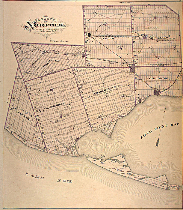
English: This map is originally from the book:
Illustrated historical atlas of the county of Norfolk, Ont. Toronto : H.R. Page & Co., 1877. The map was scanned from this book as part of the McGill University Canadian County Atlas Digital Project. (See: http://digital.library.mcgill.ca/countyatlas/default.htm) I downloaded this image of the map from their project website, specifically: http://digital.library.mcgill.ca/countyatlas/Norfolk.htm
|
| Source | |
| Auteur |
Conditions d’utilisation
Cette œuvre canadienne est dans le domaine public au Canada pour l'une ou l'autre des raisons suivantes découlant de la Loi sur le droit d’auteur :
elle n'était pas soumise au droit d'auteur de la Couronne, et
|
 |
Journal des téléversements d’origine
- 2006-05-06 06:07 Thirty-seven 611×700× (1075164 bytes) This map is originally from the book: Illustrated historical atlas of the county of Norfolk, Ont. Toronto : H.R. Page & Co., 1877. The map was scanned from this book as part of the [[McGill University]] Canadian County Atlas Digital Project. (See: http:
Historique du fichier
Cliquer sur une date et heure pour voir le fichier tel qu'il était à ce moment-là.
| Date et heure | Vignette | Dimensions | Utilisateur | Commentaire | |
|---|---|---|---|---|---|
| actuel | 13 mars 2010 à 17:00 | | 611 × 700 (1,03 Mio) | Fralambert | {{Information |Description={{en|This map is originally from the book: Illustrated historical atlas of the county of Norfolk, Ont. Toronto : H.R. Page & Co., 1877. The map was scanned from this book as part of the en:McGill University Canadian Count |
Utilisation du fichier
La page suivante utilise ce fichier :
Usage global du fichier
Les autres wikis suivants utilisent ce fichier :
- Utilisation sur en.wikipedia.org
- Utilisation sur es.wikipedia.org
- Utilisation sur uk.wikipedia.org