
Fichier:Nodaway-lewis.jpg

Fichier d’origine (889 × 843 pixels, taille du fichier : 140 kio, type MIME : image/jpeg)
Ce fichier et sa description proviennent de Wikimedia Commons.
Description
| Description |
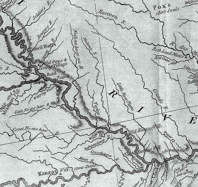
An excerpt of the Lewis and Clark Expedition map, showing a portion of the Missouri River and its tributaries.
Author: Lewis, Meriwether ; Clark, William ; Biddle, Nicholas ; Allen, Paul http://en.wikipedia.org/wiki/Image:Map_of_Lewis_and_Clark%27s_Track%2C_Across_the_Western_Portion_of_North_America%2C_published_1814.jpg Date: 1814 Short Title: Map of Lewis and Clark's Track, Across the Western Portion of North America. Publisher: Philadelphia: Bradford and Inskeep Type: Book Map Obj Height cm: 30 Obj Width cm: 70 Scale 1: 4,300,000 Note: Uncolored map showing topography and rivers in the region as well as towns, Indian villages, and population figures. Bound into the front of volume one. Reference: Howes L317; Sabin 40828; WC 13; Wheat 316. State/Province: U.S. West Full Title: A Map of Lewis and Clark's Track, Across the Western Portion of North America From the Mississippi to the Pacific Ocean; By Order of the Executive of the United States, in 1804, 5 & 6. Copied by Samuel Lewis from the Original Drawing of Wm. Clark. Smal. Harrison fct. List No: 3493.001 Series No: 2 Engraver or Printer: Lewis, Samuel ; Harrison, Samuel, 1789-1818 Publication Author: Lewis, Meriwether ; Clark, William ; Biddle, Nicholas ; Allen, Paul Pub Date: 1814 Pub Title: History Of The Expedition Under The Command Of Captains Lewis And Clark, To The Sources Of The Missouri, Thence Across The Rocky Mountains And Down The River Columbia To The Pacific Ocean. Performed During The Years 1804-5-6. By order of the Government Of The United States. Prepared For The Press By Paul Allen, Esquire. In Two Volumes. Vol. I. Philadelphia: Published By Bradford And Inskeep, New York. J. Maxwell, Printer. 1814 ... Vol. II. Pub Reference: Howes L317; Sabin 40828; WC 13; Wheat 316. Pub Note: 1st edition. Notwithstanding the title, Nicholas Biddle completed the text after Lewis's suicide. The map and the written account of the expedition changed American mapping of the northwest by giving the first accurate depiction of the relationship of the sources of the Missouri, the sources of the Columbia, and the Rocky Mountains. The map was copied by Samuel Lewis from William Clark's original drawing, and was engraved by Samuel Harrison. The title of the map is "A Map of Lewis and Clark's Track, Across the Western Portion of North America From the Mississippi to the Pacific Ocean ..." Maps are without color. In 2 volumes newly bound in full leather with the title "Lewis & Clark's Expedition ..." stamped in gilt on the spine. Pub List No: 3493.000 Pub Type: Exploration Book Pub Maps: 6 Pub Height cm: 23 Pub Width cm: 14 |
| Source | |
| Auteur |
Conditions d’utilisation
Ce document est dans le domaine public aux États-Unis. Ceci s'applique aux travaux des États-Unis où le copyright a expiré, souvent parce que sa première publication s'est produite avant le 1er janvier 1929. Voir cette page pour davantage d'explication.
|
 | |
 |
Cette image peut ne pas être dans le domaine public en dehors des États-Unis (ceci s'applique particulièrement au Canada, en Chine (pas Hong Kong, Macao, ni Taïwan), en Allemagne ou en Suisse). Le créateur et l'année de la publication sont l'information essentielle et doivent être fournis.
|
Journal des téléversements d’origine
- 2006-06-08 03:07 Americasroof 889×843×8 (142992 bytes) This is an excerpt of the Lewis and Clark map posted to Wikipedia commons. This excerpt shows the rivers in northwest Missouri. Of particular note is the Nodawa which is the Nodaway River. Author: Lewis, Meriwether ; Clark, William ; Biddle, Nicholas ;
Historique du fichier
Cliquer sur une date et heure pour voir le fichier tel qu'il était à ce moment-là.
| Date et heure | Vignette | Dimensions | Utilisateur | Commentaire | |
|---|---|---|---|---|---|
| actuel | 20 septembre 2007 à 21:56 | | 889 × 843 (140 kio) | Matthiasb | {{Information |Description=This is an excerpt of the Lewis and Clark map posted to Wikipedia commons. This excerpt shows the rivers in northwest Missouri. Of particular note is the Nodawa which is the Nodaway River. Author: Lewis, Meriwether ; Clark, W |
Utilisation du fichier
La page suivante utilise ce fichier :
Usage global du fichier
Les autres wikis suivants utilisent ce fichier :
- Utilisation sur ca.wikipedia.org
- Utilisation sur de.wikipedia.org
- Utilisation sur en.wikipedia.org
- Utilisation sur www.wikidata.org