
Fichier:Nelson Mandela Bridge (4611829625).jpg

Fichier d’origine (2 400 × 1 800 pixels, taille du fichier : 614 kio, type MIME : image/jpeg)
Ce fichier et sa description proviennent de Wikimedia Commons.
.jpg?uselang=fr)
Description
| Description |
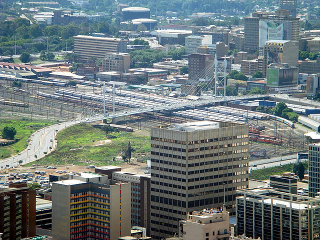
The Nelson Mandela Bridge is a bridge in Johannesburg, South Africa. It was completed in 2003 with an R38 million price tag. The proposal for the bridge was to link up two main business areas of Braamfontein and Newtown as well as to rejuvenate and to a certain level modernize the inner city, which is an initiative by a company, Blue IQ. The bridge was constructed over 42 railway lines without disturbing railway traffic and is 284 metres long. There are two pylons, North and South, and are 42 and 27 metres respectively. Engineers tried to keep the bridge as light as possible and used a structural steel with a concrete composite deck to keep weight down. Heavier banks along the bridge were reinforced by heavier back spans. The bridge consists of two lanes and has pedestrian walk-ways on either side. The bridge can be viewed from one of Johannesburg’s most popular roads, the M1 highway. Of recent times it has been known the many copper wiring has been stolen from the bridge which has causes tighter security measures, including full 24-hour video surveillance of the bridge. A bridge linking Braamfontein to the Johannesburg city centre was first mooted by Steve Thorne and Gordon Gibson, urban designers, in 1993 in their urban design study of the Inner City of Johannesburg. In their study they named the bridge the Nelson Mandela bridge in recognition of the role Nelson Mandela was having in uniting South African society, and the symbolism of linkage and unity provided by the bridge. [Wikipedia.org] |
| Date | |
| Source | Nelson Mandela Bridge |
| Auteur | Jorge Láscar from Australia |
| Lieu de la prise de vue | | Voir cet endroit et d’autres images sur : OpenStreetMap |
|---|
.jpg¶ms=-26.196700_N_0028.034200_E_globe:Earth_type:camera_source:Flickr_&language=fr)
Conditions d’utilisation
- Vous êtes libre :
- de partager – de copier, distribuer et transmettre cette œuvre
- d’adapter – de modifier cette œuvre
- Sous les conditions suivantes :
- paternité – Vous devez donner les informations appropriées concernant l'auteur, fournir un lien vers la licence et indiquer si des modifications ont été faites. Vous pouvez faire cela par tout moyen raisonnable, mais en aucune façon suggérant que l’auteur vous soutient ou approuve l’utilisation que vous en faites.
| Cette image a été originellement postée sur Flickr par Jorge Lascar à l'adresse https://www.flickr.com/photos/8721758@N06/4611829625. Elle a été passée en revue le 2 avril 2014 par le robot FlickreviewR, qui a confirmé qu'elle se trouvait sous licence cc-by-2.0. |
Historique du fichier
Cliquer sur une date et heure pour voir le fichier tel qu'il était à ce moment-là.
| Date et heure | Vignette | Dimensions | Utilisateur | Commentaire | |
|---|---|---|---|---|---|
| actuel | 2 avril 2014 à 09:50 | | 2 400 × 1 800 (614 kio) | Russavia | Transferred from Flickr |
Utilisation du fichier
La page suivante utilise ce fichier :
.jpg)