
Fichier:Nangarhar districts.png
Taille de cet aperçu : 786 × 600 pixels. Autres résolutions : 315 × 240 pixels | 629 × 480 pixels | 1 000 × 763 pixels.
Fichier d’origine (1 000 × 763 pixels, taille du fichier : 43 kio, type MIME : image/png)
Ce fichier et sa description proviennent de Wikimedia Commons.

|
Cette image (de type carte) devrait être recréée dans un format vectoriel, en tant que fichier SVG. Cela offrirait plusieurs avantages : voir Commons:Media for cleanup pour plus d'informations. Si une version SVG de cette image est déjà disponible, merci de bien vouloir l'envoyer. Après cela, remplacez ce modèle par {{vector version available|nouveau nom d'image.svg}}.
|
Description
| Description |
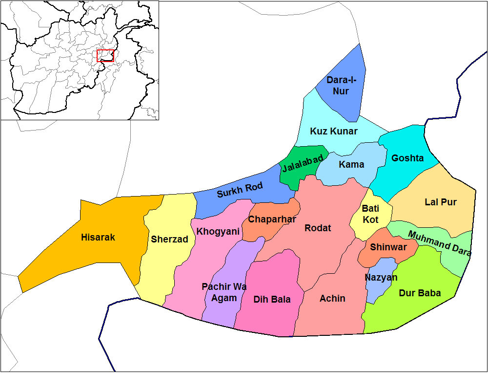
English: Map of the districts of Nangarhar province of Afghanistan. Created by Rarelibra 19:29, 29 March 2007 (UTC) for public domain use, using MapInfo Professional v8.5 and various mapping resources. |
| Date | 29 mars 2007 (date de téléversement originale) |
| Source | La source n’a pas pu être reconnue automatiquement. « Travail personnel » supposé (étant donné la revendication de droit d’auteur). |
| Auteur | L’auteur n’a pas pu être identifié automatiquement. Il est supposé qu'il s'agit de : Rarelibra (étant donné la revendication de droit d’auteur). |
Conditions d’utilisation
| Moi, propriétaire des droits d’auteur sur cette œuvre, la place dans le domaine public. Ceci s'applique dans le monde entier. Dans certains pays, ceci peut ne pas être possible ; dans ce cas : J’accorde à toute personne le droit d’utiliser cette œuvre dans n’importe quel but, sans aucune condition, sauf celles requises par la loi. |
Historique du fichier
Cliquer sur une date et heure pour voir le fichier tel qu'il était à ce moment-là.
| Date et heure | Vignette | Dimensions | Utilisateur | Commentaire | |
|---|---|---|---|---|---|
| actuel | 15 février 2024 à 16:32 | | 1 000 × 763 (43 kio) | User-duck | Cropped 5 % horizontally, 6 % vertically using CropTool with lossless mode. |
| 15 février 2024 à 16:31 |  | 1 056 × 816 (43 kio) | User-duck | Reverted to version as of 19:29, 29 March 2007 (UTC)recrop | |
| 14 février 2024 à 21:11 |  | 1 000 × 760 (43 kio) | User-duck | Cropped 5 % horizontally, 7 % vertically using CropTool with lossless mode. | |
| 29 mars 2007 à 21:29 |  | 1 056 × 816 (43 kio) | Rarelibra | Map of the districts of Nangarhar province of Afghanistan. Created by ~~~~ for public domain use, using MapInfo Professional v8.5 and various mapping resources. |
Utilisation du fichier
Les 2 pages suivantes utilisent ce fichier :
Usage global du fichier
Les autres wikis suivants utilisent ce fichier :
- Utilisation sur ar.wikipedia.org
- Utilisation sur bn.wikipedia.org
- Utilisation sur ca.wikipedia.org
- Utilisation sur cs.wikipedia.org
- Utilisation sur de.wikipedia.org
- Utilisation sur en.wikipedia.org
- Nangarhar Province
- Districts of Afghanistan
- Haji Ghalib
- Achin District
- Bati Kot District
- Chaparhar District
- Darai Nur District
- Dur Baba District
- Goshta District
- Hesarak District
- Kama District
- Khogyani District
- Kuz Kunar District
- Lal Pur District
- Momand Dara District
- Nazyan District
- Pachir Aw Agam District
- Rodat District
- Sherzad District
- User talk:Rarelibra/Maps1
- Haska Meyna District
- Khogyani (Pashtun tribe)
- Kot District
- Haska Meyna
- Battle of Tora Bora (2017)
Voir davantage sur l’utilisation globale de ce fichier.