
Fichier:NYTMap2ndBattleOfYpres1915.png
NYTMap2ndBattleOfYpres1915.png (480 × 571 pixels, taille du fichier : 69 kio, type MIME : image/png)
Ce fichier et sa description proviennent de Wikimedia Commons.
| Description |
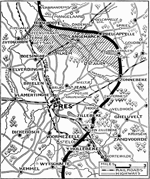
"Current History" (New York Times) map showing reported positions during the Second Battle of Ypres, as at about 30 April 1915. On 1 May the British withdrew to shorten their lines, with the final front line running through Hooge, Frenzenberg (not shown, but 1 3/4 mile sw of Zonnebeke) and west to Mouse Trap farm and Turco farms (not shown, but 1 mile sw of St Julien).
NYT caption : "The German rush across the Yser-Ypres Canal was checked at Lizerne and opposite Boesinghe. The shaded area on the map marks the scene of the battle. Within this area are Steenstraate, Het Sast, Pilkem, St. Julien, and Langemarck, all of which the Germans claimed to have captured." |
| Date | |
| Source |
New York Times Current History. The European War, Vol. 2 No. 3, June 1915. Downloaded from http://www.gutenberg.org/ebooks/15480 |
| Auteur | "Current History" (New York Times) |
Ce document est dans le domaine public aux États-Unis. Ceci s'applique aux travaux des États-Unis où le copyright a expiré, souvent parce que sa première publication s'est produite avant le 1er janvier 1929. Voir cette page pour davantage d'explication.
|
 | |
 |
Cette image peut ne pas être dans le domaine public en dehors des États-Unis (ceci s'applique particulièrement au Canada, en Chine (pas Hong Kong, Macao, ni Taïwan), en Allemagne ou en Suisse). Le créateur et l'année de la publication sont l'information essentielle et doivent être fournis.
|
Historique du fichier
Cliquer sur une date et heure pour voir le fichier tel qu'il était à ce moment-là.
| Date et heure | Vignette | Dimensions | Utilisateur | Commentaire | |
|---|---|---|---|---|---|
| actuel | 13 février 2008 à 12:26 | | 480 × 571 (69 kio) | Rcbutcher | {{Information |Description=New York Times map showing reported positions after the Second Battle of Ypres, April - May 1915. <br>NYT caption : "The German rush across the Yser-Ypres Canal was checked at Lizerne and opposite Boesinghe. The shaded area on t |
Utilisation du fichier
La page suivante utilise ce fichier :
Usage global du fichier
Les autres wikis suivants utilisent ce fichier :
- Utilisation sur de.wikipedia.org
- Utilisation sur en.wikipedia.org
- Utilisation sur es.wikipedia.org
- Utilisation sur he.wikipedia.org
- Utilisation sur it.wikipedia.org
- Utilisation sur nl.wikipedia.org