
Fichier:NRHA 1.png

Taille de cet aperçu : 533 × 600 pixels. Autres résolutions : 213 × 240 pixels | 426 × 480 pixels | 682 × 768 pixels | 910 × 1 024 pixels | 2 202 × 2 478 pixels.
Fichier d’origine (2 202 × 2 478 pixels, taille du fichier : 2,02 Mio, type MIME : image/png)
Ce fichier et sa description proviennent de Wikimedia Commons.
Description
| Description |
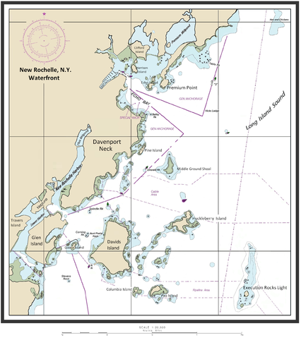
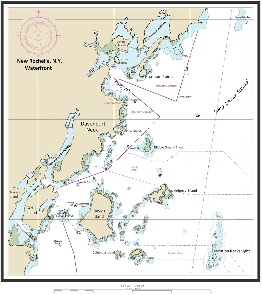
English: Map of New Rochelle waterfront including the harbor management areas, islands, and inlets. |
| Date | 14 février 2015 (date de téléversement originale) |
| Source | I (ClarckeBAR (talk)) created this work (custom map of New Rochelle Harbor Area with names/locations of geographic features, landforms). Underlying/base map data provided by The National Oceanic and Atmospheric Administration for use in nautical chart production. ( see print example (Western LIS) of published NOAA nautical chart). Main data source - The Seamless Raster Navigational Chart Server, under the following "Copyright Notice" - As required by 17 U.S.C. 403, third parties producing copyrighted works consisting predominantly of the material produced by U.S. government agencies must provide notice with such work(s) identifying the U.S. Government material incorporated and stating that such material is not subject to copyright protection within the United States. The information on government web pages is in the public domain and not subject to copyright protection within the United States unless specifically annotated otherwise (copyright may be held elsewhere). Foreign copyrights may apply. |
| Auteur | ClarckeBAR sur Wikipédia anglais |
Conditions d’utilisation
ClarckeBAR, en tant que détenteur des droits d’auteur sur cette œuvre, la publie sous la licence suivante :
Ce fichier est disponible selon les termes de la licence Creative Commons Attribution 3.0 Non transposée.
Attribution: ClarckeBAR
- Vous êtes libre :
- de partager – de copier, distribuer et transmettre cette œuvre
- d’adapter – de modifier cette œuvre
- Sous les conditions suivantes :
- paternité – Vous devez donner les informations appropriées concernant l'auteur, fournir un lien vers la licence et indiquer si des modifications ont été faites. Vous pouvez faire cela par tout moyen raisonnable, mais en aucune façon suggérant que l’auteur vous soutient ou approuve l’utilisation que vous en faites.
Journal des téléversements d’origine
La page de description originale était ici. Tous les noms d'utilisateur qui suivent se rapportent à en.wikipedia.
| Date et heure | Dimensions | Utilisateur | Commentaire |
|---|---|---|---|
| 2015-02-14 10:46 | 2202×2478× (2113870 bytes) | ClarckeBAR | {{Information |Description = Map of New Rochelle waterfront including the harbor management areas, islands, and inlets. |Source = I (~~~) created this work entirely by myself. |Date = ~~~~~ |Author = ~~~ |other_version... |
Historique du fichier
Cliquer sur une date et heure pour voir le fichier tel qu'il était à ce moment-là.
| Date et heure | Vignette | Dimensions | Utilisateur | Commentaire | |
|---|---|---|---|---|---|
| actuel | 4 septembre 2015 à 08:28 | | 2 202 × 2 478 (2,02 Mio) | Innotata | Transferred from en.wikipedia |
Utilisation du fichier
La page suivante utilise ce fichier :
Usage global du fichier
Les autres wikis suivants utilisent ce fichier :
- Utilisation sur ceb.wikipedia.org
- Utilisation sur de.wikipedia.org
- Utilisation sur en.wikipedia.org
- Westchester County, New York
- Columbia Island (New York)
- Travers Island, New York
- Pea Island (New Rochelle, New York)
- Titus Mill-Pond & New York State Tidal Wetlands
- New Rochelle Harbor (Long Island Sound)
- Echo Bay (Long Island Sound)
- Davenport Neck
- Premium Point, New Rochelle
- Pine Island (New Rochelle)
- Premium Mill-Pond
- Utilisation sur fi.wikipedia.org
- Utilisation sur ja.wikipedia.org
- Utilisation sur www.wikidata.org