
Fichier:Morrison Formation from near Notom-Bullfrog Road in southern Capitol Reef National Park.jpg
Morrison_Formation_from_near_Notom-Bullfrog_Road_in_southern_Capitol_Reef_National_Park.jpg (800 × 600 pixels, taille du fichier : 497 kio, type MIME : image/jpeg)
Ce fichier et sa description proviennent de Wikimedia Commons.
Description
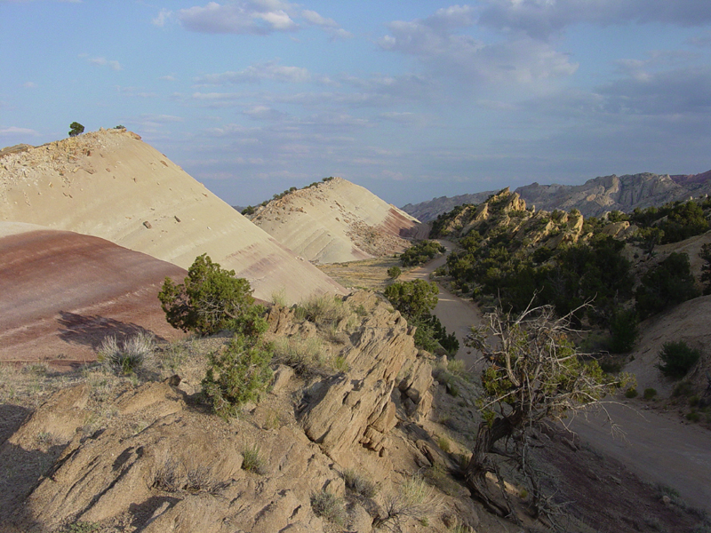
USGS photo from [1] Red and gray shale of the Morrison Formation form from volcanic ash deposited an a broad coastal floodplain during the Jurassic Period (between 208 and 144 million years ago). The sand bed in the foreground probably represent old stream channel deposits. When the sediments were originally deposited they were nearly flat lying, but the tectonic forces that shaped the Waterpocket Fold in the Tertiary Period resulted in the rock layers dipping steeply to the left. These outcrops are along the Notom-Bullfrog Road in southern Capitol Reef National Park.
Conditions d’utilisation
Ce média est dans le domaine public des États-Unis d’Amérique car son auteur est l’administration américaine comme précisé dans le code fédéral au Titre 17, Chapitre 1, Section 105. Pour en savoir plus : droit d’auteur.
Attention : Ceci ne concerne que le travail du Gouvernement Fédéral et pas celui des États, ou d’une autre subdivision géographique ou politique du pays.
|
 | |
| Ce fichier a été identifié comme étant exempt de restrictions connues liées au droit d’auteur, y compris tous les droits connexes et voisins. | ||
Historique du fichier
Cliquer sur une date et heure pour voir le fichier tel qu'il était à ce moment-là.
| Date et heure | Vignette | Dimensions | Utilisateur | Commentaire | |
|---|---|---|---|---|---|
| actuel | 16 mars 2006 à 04:28 | | 800 × 600 (497 kio) | Mav | USGS photo from [http://3dparks.wr.usgs.gov/capitol2/html/3d068.html] Red and gray shale of the Morrison Formation form from volcanic ash deposited an a broad coastal floodplain during the Jurassic Period (between 208 and 144 million years ago). The sand |
Utilisation du fichier
La page suivante utilise ce fichier :
Usage global du fichier
Les autres wikis suivants utilisent ce fichier :
- Utilisation sur ar.wikipedia.org
- Utilisation sur en.wikipedia.org