
Fichier:Meteorological US surface map 20061012.gif

Taille de cet aperçu : 800 × 576 pixels. Autres résolutions : 320 × 230 pixels | 640 × 461 pixels | 1 024 × 737 pixels | 1 088 × 783 pixels.
Fichier d’origine (1 088 × 783 pixels, taille du fichier : 71 kio, type MIME : image/gif)
Ce fichier et sa description proviennent de Wikimedia Commons.
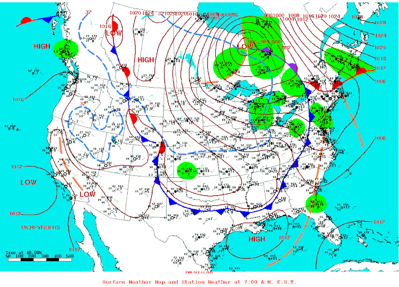
| Description | Department of Commerce National Weather Service surface Map for the 12th of October 2006 showing the cold air dome invading the southern Great Lakes and causing a Lake Effect Snow Storm that left up to 60 cm of snow in a narrow band around Buffalo, NY. | |||
| Date | (UTC) | |||
| Source | NOAA | |||
| Auteur | Hydrological Prediction Center of NOAA | |||
| Autorisation (Réutilisation de ce fichier) |
|
Historique du fichier
Cliquer sur une date et heure pour voir le fichier tel qu'il était à ce moment-là.
| Date et heure | Vignette | Dimensions | Utilisateur | Commentaire | |
|---|---|---|---|---|---|
| actuel | 25 novembre 2007 à 01:34 | | 1 088 × 783 (71 kio) | Pierre cb | {{Information |Description=Department of Commerce National Weather Service surface Map for the 12th of October 2006 showing the cold air dome invading the southern Great Lakes and causing a Lake Effect Snow Storm that left up to 60 cm of snow in a nar |
Utilisation du fichier
La page suivante utilise ce fichier :
Usage global du fichier
Les autres wikis suivants utilisent ce fichier :
- Utilisation sur en.wikipedia.org