
Fichier:Map of Florida by John de Solís (1764).jpg

Taille de cet aperçu : 460 × 599 pixels. Autres résolutions : 184 × 240 pixels | 368 × 480 pixels | 589 × 768 pixels | 786 × 1 024 pixels | 2 075 × 2 704 pixels.
Fichier d’origine (2 075 × 2 704 pixels, taille du fichier : 634 kio, type MIME : image/jpeg)
Ce fichier et sa description proviennent de Wikimedia Commons.
.jpg?uselang=fr)
Description
| Description |
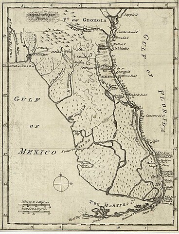
English: Map of Florida of ca. 1764]].
|
| Date | vers 1764 |
| Source | US Library of Congress |
| Auteur | "Don John de Solís, surveyor, who resided there near twenty years" |
Conditions d’utilisation
|
Cette œuvre est également dans le domaine public dans tous les pays pour lesquels le droit d’auteur a une durée de vie de 100 ans ou moins après la mort de l’auteur. | |
| Ce fichier a été identifié comme étant exempt de restrictions connues liées au droit d’auteur, y compris tous les droits connexes et voisins. | |
Historique du fichier
Cliquer sur une date et heure pour voir le fichier tel qu'il était à ce moment-là.
| Date et heure | Vignette | Dimensions | Utilisateur | Commentaire | |
|---|---|---|---|---|---|
| actuel | 28 mai 2018 à 01:06 | | 2 075 × 2 704 (634 kio) | Hispalois | Higher-resolution image. Please note that this map has no relationship whatsoever with 16th-century explorer Juan Díaz de Solís. |
| 15 juin 2006 à 19:16 |  | 399 × 500 (49 kio) | Eamezaga | Map published in the US depicting a very accurate shape of Florida (1764), based on an ancient draft drawn by the Spanish-Portuguese explorer and discoverer Juan Díaz de Solís (US Library of Congress, released to public domain) |
Utilisation du fichier
Aucune page n’utilise ce fichier.
Usage global du fichier
Les autres wikis suivants utilisent ce fichier :
- Utilisation sur en.wikipedia.org
- Utilisation sur it.wikipedia.org
.jpg)